In partnership with: 
|
March 23, 2013 at 7:00 am |
|
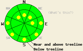
In above treeline terrain, a few isolated pockets of MODERATE avalanche danger may remain on NW-N-NE-E aspects on slopes 35 degrees and steeper due to lingering wind slabs. Below treeline pockets of MODERATE avalanche danger may form due to daytime warming on the sun-exposed E-SE-S-SW-W aspects on slopes steeper than 35 degrees. |
|
|
|
A high pressure ridge over the region will allow the sunny dry weather to continue for the next several days. As this ridge becomes more established temperatures should gradually increase and the northerly winds should continue to decrease. The forecast calls for light to moderate north and northeast winds today and tomorrow and daytime highs in the upper 30's to upper 40's above 7000 ft.
On Tamarack Peak (photos, videos, snowpit, more info) and Mt. Tallac (photos, video, more info) yesterday, cooler temperatures and light northeast winds kept the snowpack mostly frozen. In both of these areas, observers did not report any significant wet snow instabilities even on the sun-exposed southerly aspects. On the previously wind loaded N-NE-E aspects, some wind slabs did still exist in both areas. Tests on these wind slabs indicated that they have bonded to the snow below them and that they have become difficult to trigger. Widespread signs of settlement and consolidation existed on Mt. Tallac. On the most exposed upper elevation ridgelines, NE winds during the Thursday night had scoured some of the NE aspects in both areas.This scouring remained limited and snow transport did not continue yesterday due to a lack of wind.
On N aspects in the Tamarack Peak area where a colder snowpack exists, the older March 6th facets remain. This layer of soft sugary snow now rests 12-18 inches down from the surface below a crust. Snowpit tests on this persistent weak layer indicated that if these facets break the ensuing fracture could travel along this layer (videos). Observations like ski cuts on test slopes and other general observations did not trigger signs of instability or failure of this layer.
Avalanche Problem #1: Loose Wet Avalanches
Strong March sunshine and slightly warmer daytime highs could allow enough melting to occur today for some wet loose avalanches to become possible. The strong overnight refreeze, light northerly winds, some afternoon clouds, and the gradual pace of the warming should should help limit the formation of wet snow instabilities. Roller balls, pinwheels, and wet loose point releases should represent the majority of wet snow instabilities that form today. The below treeline sun-exposed E-SE-S-SW-W aspects hold the best potential for wet snow instabilities. If temperatures reach the upper end of the forecasted range or climb higher than predicted wet snow instabilities could become more widespread.
Avalanche Problem #2: Wind Slabs
Triggering one of the wind slabs that linger on the wind loaded near and above treeline NW-N-NE-E aspects has become unlikely in most areas. However, human triggering of these slabs may remain possible in a few isolated spots in complex or extreme terrain or in areas where the wind slabs exist on steep unsupported slopes.
Tracking Persistent Slabs:
The March 6th facets still exist as a persistent weak layer on some isolated upper elevation N aspects where the snowpack has stayed cold. So far data showing that fractures can still propagate along this layer has remained limited to some areas in the Mt. Rose backcountry. In the areas where this layer exists data indicates triggering a persistent slab avalanche remains unlikely. Even though avalanche activity on this layer remains unlikely at this time, it still could pose problems in the future as conditions change.
In above treeline terrain, a few isolated pockets of MODERATE avalanche danger may remain on NW-N-NE-E aspects on slopes 35 degrees and steeper due to lingering wind slabs. Below treeline pockets of MODERATE avalanche danger may form due to daytime warming on the sun-exposed E-SE-S-SW-W aspects on slopes steeper than 35 degrees.
| 0600 temperature: | 20-28 deg. F. |
| Max. temperature in the last 24 hours: | 31-43 deg. F. |
| Average wind direction during the last 24 hours: | Northeast |
| Average wind speed during the last 24 hours: | 10-15 mph |
| Maximum wind gust in the last 24 hours: | 38 mph |
| New snowfall in the last 24 hours: | O inches |
| Total snow depth: | 51-88 inches |
For 7000-8000 ft: |
|||
| Saturday: | Saturday Night: | Sunday: | |
| Weather: | Sunny with a few clouds this afternoon | Mostly clear with a few scattered clouds before midnight | Sunny |
| Temperatures: | 40-46 deg. F. | 20-28 deg. F. | 42-50 deg. F. |
| Wind direction: | East | Variable | Variable |
| Wind speed: | Light | Light | Light |
| Expected snowfall: | O in. | O in. | O in. |
For 8000-9000 ft: |
|||
| Saturday: | Saturday Night: | Sunday: | |
| Weather: | Sunny with a few clouds this afternoon | Mostly clear with a few scattered clouds before midnight | Sunny |
| Temperatures: | 35-41 deg. F. | 18-27 deg. F. | 35-44 deg. F. |
| Wind direction: | North shifting to the south in the afternoon | West | Northeast |
| Wind speed: | 15-25 mph with gusts to 35 mph | 15-20 mph with gusts to 30 mph | 15-20 mph with gusts to 30 mph |
| Expected snowfall: | O in. | O in. | O in. |


This website is owned and maintained by the non-profit arm of the Sierra Avalanche Center. Some of the content is updated by the USDA avalanche forecasters including the forecasts and some observational data. The USDA is not responsible for any advertising, fund-raising events/information, or sponsorship information, or other content not related to the forecasts and the data pertaining to the forecasts.

