In partnership with: 
|
March 24, 2013 at 7:00 am |
|
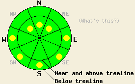
In near and above treeline terrain, a few isolated pockets of MODERATE avalanche danger may remain on NW-N-NE aspects on slopes 35 degrees and steeper due to lingering wind slabs. Below treeline pockets of MODERATE avalanche danger may form due to daytime warming on the sun-exposed E-SE-S-SW-W aspects on slopes steeper than 35 degrees. |
|
|
|
Light winds, gradual warming, and sunny skies should continue across the forecast area due to a high pressure ridge sitting over the region. Daytime highs could reach into the 40's above 7000 ft today and tomorrow with a few areas climbing into the low 50's between 7000 and 8000 ft. By tomorrow some mid to upper level clouds may develop across the region as a small low pressure drifts into the northwest.
Yesterday observations along Meiss Ridge (photos, snowpit, more info) and on Incline Lake Peak (videos, photos, more info) revealed 2-3 inches of soft wet snow above a supportable layer of melt-freeze snow on the SE-S-SW aspects with no signs of wet snow instabilities in these areas. On the northerly aspects some soft snow still remains above a thin melt freeze crust on the more sheltered aspects. On Incline Lake Peak a breakable melt freeze crust existed in any areas that received sunshine on the N-NE-E aspects. Wind slabs did exist on wind loaded N-NE aspects in near and above treeline terrain in these area. Tests on the wind slabs along Meiss Ridge did not reveal signs of instability. On Incline Lake Peak snowpit tests indicated that the wind slabs have become difficult to trigger but if they do break the resulting fracture could still propagate along the base of the wind slabs (video).
In both of these areas the March 6th facet layer did exist about 10-16 inches deep in the snowpack; however, it has consolidated nicely. Tests on this layer indicated that it has become difficult to break and that any fractures that do occur in it would not travel very far (video). On Friday observations from the Tamarack Peak area showed more potential for both fractures and propagation along this layer (videos). Even in the few areas where this layer exists data indicates triggering a persistent slab avalanche remains unlikely unless conditions change.
Avalanche Problem #1: Loose Wet Avalanches
Strong March sunshine and slightly warmer daytime highs could allow enough melting to occur today for some wet loose avalanches to become possible. The strong overnight refreeze and the gradual pace of the warming should should help limit the formation of wet snow instabilities. Roller balls, pinwheels, and wet loose point releases should represent the majority of wet snow instabilities that form today. The below treeline sun-exposed E-SE-S-SW-W aspects hold the best potential for wet snow instabilities.
Avalanche Problem #2: Wind Slabs
Triggering one of the wind slabs that linger on the wind loaded near and above treeline NW-N-NE aspects has become unlikely in most areas. However, human triggering of these slabs may remain possible in a few isolated spots in complex or extreme terrain or in areas where the wind slabs exist on steep unsupported slopes.
In near and above treeline terrain, a few isolated pockets of MODERATE avalanche danger may remain on NW-N-NE aspects on slopes 35 degrees and steeper due to lingering wind slabs. Below treeline pockets of MODERATE avalanche danger may form due to daytime warming on the sun-exposed E-SE-S-SW-W aspects on slopes steeper than 35 degrees.
| 0600 temperature: | 26-31 deg. F. |
| Max. temperature in the last 24 hours: | 37-46 deg. F. |
| Average wind direction during the last 24 hours: | Southwest to Northwest |
| Average wind speed during the last 24 hours: | 10-20 mph |
| Maximum wind gust in the last 24 hours: | 40 mph |
| New snowfall in the last 24 hours: | O inches |
| Total snow depth: | 50-87 inches |
For 7000-8000 ft: |
|||
| Sunday: | Sunday Night: | Monday: | |
| Weather: | Sunny | Mostly clear to partly cloudy | Partly cloudy |
| Temperatures: | 43-51 deg. F. | 25-35 deg. F. | 44-51 deg. F. |
| Wind direction: | Variable | West | Variable |
| Wind speed: | Light | 10-15 mph in the evening decreasing overnight | Light |
| Expected snowfall: | O in. | O in. | O in. |
For 8000-9000 ft: |
|||
| Sunday: | Sunday Night: | Monday: | |
| Weather: | Sunny | Mostly clear to partly cloudy | Partly cloudy |
| Temperatures: | 36-45 deg. F. | 25-35 deg. F. | 38-45 deg. F. |
| Wind direction: | Northwest | West | South |
| Wind speed: | 10-15 mph with gusts to 25 mph | 10-15 mph with gusts to 25 mph in the evening decreasing overnight | 10-15 mph with gusts to 25 mph |
| Expected snowfall: | O in. | O in. | O in. |


This website is owned and maintained by the non-profit arm of the Sierra Avalanche Center. Some of the content is updated by the USDA avalanche forecasters including the forecasts and some observational data. The USDA is not responsible for any advertising, fund-raising events/information, or sponsorship information, or other content not related to the forecasts and the data pertaining to the forecasts.

