In partnership with: 
|
March 30, 2013 at 7:00 am |
|
Pockets of MODERATE avalanche danger will form today on slopes steeper than 37 degrees below 8,000' due to daytime warming and rain on snow. Human triggered wet loose avalanches will be possible in some areas. |
|
|
|
Cloud cover started to increase last night and should continue to build as a low pressure approaches the area. By this afternoon rain and snow showers should begin across the region. The forecast calls for snow levels to remain near 8000 ft. through tomorrow morning. During this time most of the precipitation should fall. By tomorrow morning snow levels should gradually drop to between 6500 and 7000 ft. 3-7 inches of wet heavy snow could accumulate above 8000 ft. by the end of the day tomorrow with mostly rain falling below 8000 ft. This system could also produce thunderstorm activity over the next 36 hours. The winds should remain light to moderate today and tomorrow as this low pressure meanders through the region. For more information on this storm check in with the Reno NWS.
Yesterday, minor loose wet snow instabilities occurred on steep slopes on Maggies Peak (photos, snowpit, more info) and in the Mt. Rose area below 9000 ft (photos, video, more info). Above 9000 ft. in the Mt. Houghton area a trace of new snow existed above a frozen melt-freeze crust. Below the surface at these upper elevations, the snow remained cold and dry, and snowpit data did not reveal signs of instability (video). On the more sun-exposed southerly aspects, 3-4 inches of soft wet snow existed above a supportable melt-freeze layer. Farther south on Maggies Peak, wet snow extending to the ground existed on all aspects up to 8000 ft (snowpit, photo, more info). Above this elevation some of the north aspects still held some areas of colder snow. On the SE-S-SW aspects of Maggies Peak large areas of dirt and rocks have melted out.
Avalanche Problem #1: Loose Wet Avalanches
Increased cloud cover overnight and temperatures above freezing should have limited the overnight refreeze. This morning's sunshine and warmer temperatures will quickly melt this thin refreeze allowing wet snow to form on the sun-exposed E-SE-S-SW-W aspects. Increased cloud cover and rain showers today will allow melting to spread to the northerly aspects as well. Wet snow instabilities will become possible today. Since the snowpack has undergone several melt-freeze cycles, well established drainage channels exist through the snowpack in many places. These drainage channels help move free water through the snowpack and prevent it from weakening the snowpack as much as it does when the water pools in one layer. For this reason wet snow instabilities should remain limited to point releases, roller balls, and other loose wet snow instabilities.
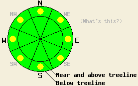
Pockets of MODERATE avalanche danger will form today on slopes steeper than 37 degrees below 8,000' due to daytime warming and rain on snow. Human triggered wet loose avalanches will be possible in some areas.
| 0600 temperature: | 34-39 deg. F. |
| Max. temperature in the last 24 hours: | 42-54 deg. F. |
| Average wind direction during the last 24 hours: | Southwest shifting to the east after midnight |
| Average wind speed during the last 24 hours: | 10-15 mph |
| Maximum wind gust in the last 24 hours: | 31 mph |
| New snowfall in the last 24 hours: | O inches |
| Total snow depth: | 46-83 inches |
For 7000-8000 ft: |
|||
| Saturday: | Saturday Night: | Sunday: | |
| Weather: | Partly cloudy this morning with a slight chance of rain showers. Rain and snow showers becoming more widespread this afternoon. Some isolated thunderstorms are possible. Snow levels above 8000 ft. | A mix of rain and snow with some isolated thunderstorms possible. Snow level 7500-8000 ft. | Snow with isolated thunderstorms in the afternoon. Snow level falling to 6500-7000 ft. |
| Temperatures: | 46-53 deg. F. | 30-36 deg. F. | 33-43 deg. F. |
| Wind direction: | East | Variable | Southwest |
| Wind speed: | 5-10 mph | Light | 10-15 mph with gusts to 25 mph |
| Expected snowfall: | O in. | above 7500 ft. up to 3 in. | 1-2 in. |
For 8000-9000 ft: |
|||
| Saturday: | Saturday Night: | Sunday: | |
| Weather: | Partly cloudy this morning with a slight chance of rain showers. Rain and snow showers becoming more widespread this afternoon. Some isolated thunderstorms are possible. Snow levels 8000-8500 ft. | Snow with some isolated thunderstorms possible. | Snow with isolated thunderstorms in the afternoon. |
| Temperatures: | 36-46 deg. F. | 24-32 deg. F. | 25-33 deg. F. |
| Wind direction: | East shifting to the south in the afternoon | Southwest | Southwest |
| Wind speed: | 10-20 mph decreasing to 10-15 mph with gusts to 25 mph in the afternoon | 10-15 mph with gusts to 25 mph | 15-20 mph with gusts to 40 mph |
| Expected snowfall: | trace to 0 in. | 2-5 in. | 1-2 in. |


This website is owned and maintained by the non-profit arm of the Sierra Avalanche Center. Some of the content is updated by the USDA avalanche forecasters including the forecasts and some observational data. The USDA is not responsible for any advertising, fund-raising events/information, or sponsorship information, or other content not related to the forecasts and the data pertaining to the forecasts.

