In partnership with: 
|
April 8, 2013 at 6:40 am |
|
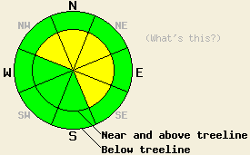
Near and above treeline, areas of MODERATE avalanche danger exist on NW-N-NE-E-SE aspects on slopes 35 degrees and steeper due to newly formed wind slabs. For all other areas, avalanche danger remains LOW. |
|
|
|
A strong cold front passed through the forecast area early this morning, bringing strong winds ahead of the front, colder air temperatures, and 1 to 4 inches of new snow. Snowfall activity will quickly diminish this morning with scattered to isolated snow shower activity through this afternoon. Additional new snow amounts of up to 1 inch are possible today. Ridgetop winds have shifted from southwest to northeast this morning. Wind speeds may lull at times today, but periods of strong northeast winds are expected today, tonight, and tomorrow. Remote sensors are reporting air temperatures above 8,000' in the upper teens to mid 20s this morning. Maximum daytime air temperatures are forecast to reach the mid 20s to low 30s today for areas above 7,000'.
Observations made yesterday on Rubicon Peak (West Shore Tahoe area) revealed widespread melt-freeze and rain crust at the snow surface from the trailhead to the summit. Very hard crust covered the snow surface in nearly all areas above 7,800'. Evidence of a strong overnight refreeze existed at all elevations traveled from 6,940' to about 9,000'. No areas of wind loading were observed along the NW ridge near the summit. The snow surface was very hard melt-freeze and rain crust about 2.5 inches thick. Ski edge penetration into this surface crust was less than 1/4 inch. About 2 inches of recent new snow existed on wind protected E aspects above 8,500'. The top 1 inch was in melt phase at 11am. Bonding of this recent storm snow to the melt-freeze crust below was very good. Below 8,500' significant amounts of unfrozen wet snow existed below the surface melt-freeze crust. By 11:15am, snow surface conditions on E aspects at 8,450' had become marginally supportable on skis with boot penetration to boot top depth in wet snow (photos, more info).
Avalanche Problem #1: Wind Slabs
New snow and wind last night is expected to have formed areas of fresh wind slab in near and above treeline terrain. Shallow wind slabs less 1 foot thick are expected to exist on NW-N-NE-E-SE aspects today. Widespread wind slabs are not expected. Areas of instability will be focused to the most heavily wind loaded slopes. As NE winds increase today, some redistribution of snow is expected to occur. Additional cross loading is possible on NW, E, and SE aspects, but snow amounts available for wind transport are insufficient to create much in the way of new wind slab formation on S-SW-W aspects. Human triggered avalanches are possible today in specific areas, natural avalanches are unlikely.
Near and above treeline, areas of MODERATE avalanche danger exist on NW-N-NE-E-SE aspects on slopes 35 degrees and steeper due to newly formed wind slabs. For all other areas, avalanche danger remains LOW.
| 0600 temperature: | 20 to 26 deg. F. |
| Max. temperature in the last 24 hours: | 30 to 43 deg. F. |
| Average wind direction during the last 24 hours: | Southwest |
| Average wind speed during the last 24 hours: | 48 mph |
| Maximum wind gust in the last 24 hours: | 77 mph |
| New snowfall in the last 24 hours: | 1 to 4 inches |
| Total snow depth: | 44 to 81 inches |
For 7000-8000 ft: |
|||
| Monday: | Monday Night: | Tuesday: | |
| Weather: | Mostly cloudy skies with scattered snow showers in the morning. Isolated snow showers in the afternoon. | Partly cloudy skies. | Partly cloudy skies. |
| Temperatures: | 29 to 34 deg. F. | 14 to 21 deg. F. | 38 to 44 deg. F. |
| Wind direction: | NE | NE | NE |
| Wind speed: | 20 to 30 mph with gusts to 45 mph. | 20 to 30 mph with gusts to 40 mph. Gusts increasing to 50 mph after midnight. | 20 to 30 mph with gusts to 50 mph. |
| Expected snowfall: | Up to 1 in. | O in. | O in. |
For 8000-9000 ft: |
|||
| Monday: | Monday Night: | Tuesday: | |
| Weather: | Mostly cloudy skies with scattered snow showers in the morning. Isolated snow showers in the afternoon. | Partly cloudy skies. | Partly cloudy skies. |
| Temperatures: | 27 to 31 deg. F. | 12 to 19 deg. F. | 36 to 42 deg. F. |
| Wind direction: | NE | NE | NE |
| Wind speed: | 30 to 45 mph with gusts to 70 mph. | 25 to 35 mph with gusts to 55 mph, increasing to 40 to 50 mph with gusts to 70 mph after midnight. | 35 to 45 mph with gusts to 70 mph. |
| Expected snowfall: | Up to 1 in. | O in. | O in. |


This website is owned and maintained by the non-profit arm of the Sierra Avalanche Center. Some of the content is updated by the USDA avalanche forecasters including the forecasts and some observational data. The USDA is not responsible for any advertising, fund-raising events/information, or sponsorship information, or other content not related to the forecasts and the data pertaining to the forecasts.

