THIS AVALANCHE FORECAST EXPIRED ON April 12, 2013 @ 7:00 am
Avalanche Forecast published on April 11, 2013 @ 7:00 am
Issued by Andy Anderson - Tahoe National Forest - Sierra Avalanche Center

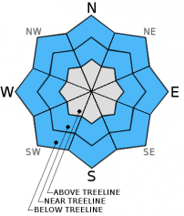
Small pockets of MODERATE avalanche danger may exist on near and below treeline slopes steeper than 35 degrees that received rain last night and this morning. Daytime warming may also cause small shallow wet snow instabilities to form.

1. Low

?

Above Treeline
Generally safe avalanche conditions. Watch for unstable snow on isolated terrain features.

2. Moderate

?

Near Treeline
Heightened avalanche conditions on specific terrain features. Evaluate snow and terrain carefully; identify features of concern.

2. Moderate

?

Below Treeline
Heightened avalanche conditions on specific terrain features. Evaluate snow and terrain carefully; identify features of concern.
    Heightened avalanche conditions on specific terrain features. Evaluate snow and terrain carefully; identify features of concern.
Avalanche Problem 1: Loose Wet
  • Type ?
  • Aspect/Elevation ?
  • Likelihood ?
    Certain
    Very Likely
    Likely
    Possible
    Unlikely
  • Size ?
    Historic
    Very Large
    Large
    Small

Rain on the snow in some areas, warm overnight temperatures, and cloudy skies last night should have prevented the snowpack from experiencing much of a refreeze. Warm weather and some sunshine today could allow wet snow to become more widespread. Some wet snow instabilities like roller balls, pinwheels, and wet point releases may continue today. Since the snowpack has undergone so many melt-freeze cycles, well established drainage channels that should prevent water from pooling in specific layers already exist. This drainage should prevent larger wet snow instabilities from forming. Even though these loose wet avalanches should remain small and shallow, they could still push a person into an area with other consequences or could become more serious in areas where terrain traps exist. Wet slab avalanches remain unlikely today; however, they are not impossible. In the unlikely event a wet slab did occur, it should also remain shallow and only involve the recent snow.

recent observations

Yesterday on Castle Peak ski cuts on sun-exposed SE-S-SW aspects did cause some small roller balls and pinwheels up to 1 ft in diameter. These instabilities only occurred where recent snow that had not transitioned to corn still remained. On slopes where the recent snow had melted or scoured away 1-3 inches of corn snow existed above a supportable melt-freeze layer. On the northerly aspects scoured surfaces existed in most places with some patches of wet sticky soft snow in wind sheltered areas. Below the surface the snowpack consisted of a mix of frozen crusts and moist snow layers (snowpit, more info).

Weather and CURRENT CONDITIONS
weather summary

A small cold front moving through western NV brought some light showers to the mountains east of Lake Tahoe. These showers should end this morning as the cold front moves out of the area. Daytime highs today should remain a few degrees cooler than yesterday's highs. The forecast indicates a high pressure ridge building over the forecast area for the next few days. Cloud cover should begin to dissipate today leaving clear skies overnight and sunny warm weather for tomorrow. The winds should shift back to the NE today and decrease as the high pressure takes charge.

CONDITIONS ALONG THE SIERRA CREST BETWEEN 8200 FT. AND 9200 FT. IN THE LAST 24 HOURS
6am temperature: 31-36 deg. F.
Max. temperature: 49-53 deg. F.
Average ridgetop wind direction: Northeast shifting to southwest overnight
Average ridgetop wind speed: 15-25 mph
Maximum ridgetop wind gust: 57 mph
New snowfall: rain: .1 inches
Total snow depth: 44-82 inches
Two-Day Mountain Weather Forecast Produced in partnership with the Reno NWS
For 7000 ft. to 8000 ft.
Thursday Thursday Night Friday
Weather: Mostly cloudy with some light showers possible in the morning becoming partly sunny this afternoon Partly cloudy becoming clear overnight Sunny with some clouds developing in the afternoon
Temperatures: 45-52 deg. F. 29-34 deg. F. 52-58 deg. F.
Mid Slope Winds: NW-N shifting to NE-E during the morning NE E shifting to the W in the afternoon
Wind Speed: 10-15 mph decreasing to 5-10 mph 10-15 mph 5-10 mph
Expected snowfall: 0 0 0
For 8000 ft. to 9000 ft.
Thursday Thursday Night Friday
Weather: Mostly cloudy with some light showers possible in the morning becoming partly sunny this afternoon Partly cloudy becoming clear overnight Sunny with some clouds developing in the afternoon
Temperatures: 38-45 deg. F. 27-32 deg. F. 45-52 deg. F.
Ridge Top Winds: NW shifting to the NE during the morning NE E shifting to the W in the afternoon
Wind Speed: 10-20 mph with gusts to 30 mph decreasing to 10-15 mph 10-15 mph with gusts to 25 mph 5-15 mph
Expected snowfall: 0 0 0
Disclaimer

This avalanche advisory is provided through a partnership between the Tahoe National Forest and the Sierra Avalanche Center. This advisory covers the Central Sierra Nevada Mountains between Yuba Pass on the north and Ebbetts Pass on the south. Click here for a map of the forecast area. This advisory applies only to backcountry areas outside established ski area boundaries. This advisory describes general avalanche conditions and local variations always occur. This advisory expires 24 hours after the posted time unless otherwise noted. The information in this advisory is provided by the USDA Forest Service who is solely responsible for its content.