THIS AVALANCHE FORECAST EXPIRED ON April 14, 2013 @ 6:36 am
Avalanche Forecast published on April 13, 2013 @ 6:36 am
Issued by Brandon Schwartz - Tahoe National Forest

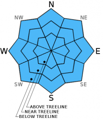
Early this morning, avalanche danger is LOW for all elevations and aspects. As the day progresses, areas of MODERATE danger will form on all aspects at all elevations on slopes 37 degrees and steeper in response to daytime warming. Small human triggered loose wet avalanches will become possible.

2. Moderate

?

Above Treeline
Heightened avalanche conditions on specific terrain features. Evaluate snow and terrain carefully; identify features of concern.

2. Moderate

?

Near Treeline
Heightened avalanche conditions on specific terrain features. Evaluate snow and terrain carefully; identify features of concern.

2. Moderate

?

Below Treeline
Heightened avalanche conditions on specific terrain features. Evaluate snow and terrain carefully; identify features of concern.
    Heightened avalanche conditions on specific terrain features. Evaluate snow and terrain carefully; identify features of concern.
Avalanche Problem 1: Loose Wet
  • Type ?
  • Aspect/Elevation ?
  • Likelihood ?
    Certain
    Very Likely
    Likely
    Possible
    Unlikely
  • Size ?
    Historic
    Very Large
    Large
    Small

A marginal to decent snow surface refreeze is expected to have occurred last night due to near to above freezing air temperatures and radiational cooling of the upper snowpack slightly limited by thin cloud cover overnight. As daytime warming progresses, the snow surface is expected to transition quickly today from frozen and supportable to melt phase with developing wet snow instability. Human triggered loose wet avalanches will become possible from late morning onward, especially during the afternoon and evening hours. Most areas of instability will exist on E-SE-S-SW-W aspects, spreading to include areas on NW-N-NE aspects later in the day. With many previous melt-freeze cycles and previous rain events having already occurred this winter and spring, free water drainage from the snowpack is well established. This is expected to keep loose wet avalanche activity limited to human triggered avalanches that are relatively small in size.

recent observations

Observations made yesterday on Rubicon Peak (West Shore Tahoe area) revealed evidence of a decent snow surface refreeze Thursday night. During the morning hours, a 3 to 5 inch thick surface melt-freeze crust existed in this area on all aspects up to the high point of travel at 9,100'. The thickness of the melt-freeze crust increased with elevation. Unfrozen wet snow existed below this surface crust. By 12:15 pm on E aspects below 8,300', the crust was fully melted and the snowpack was becoming unsupportable for a person on skis. On N-NW aspects at 1 pm, the snow surface had experienced less melting and remained supportable down to the lower limit of connected snow patches in this area at about 7,100' (photos, more info).

Weather and CURRENT CONDITIONS
weather summary

Partly cloudy skies, warm air temperatures, and windy conditions are expected across the forecast area today. Similar conditions are forecast for tomorrow before a cold front moves through the region on Monday. This morning, remote sensors above 8,000' are reporting air temperatures in the mid 30s to low 40s. This is about 5 degrees warmer than 24 hours ago and 10 degrees warmer than 48 hours ago. Maximum daytime air temperatures are forecast to reach the mid 40s to upper 50s today above 7,000'. Ridgetop winds shifted from northeast to southwest around mid day yesterday, becoming moderate in speed during the overnight hours. Moderate to strong southwest winds are forecast to continue through tomorrow.

CONDITIONS ALONG THE SIERRA CREST BETWEEN 8200 FT. AND 9200 FT. IN THE LAST 24 HOURS
6am temperature: 34 to 41 deg. F.
Max. temperature: 48 to 56 deg. F.
Average ridgetop wind direction: SW
Average ridgetop wind speed: 22 mph
Maximum ridgetop wind gust: 42 mph
New snowfall: 0 inches
Total snow depth: 40 to 81 inches
Two-Day Mountain Weather Forecast Produced in partnership with the Reno NWS
For 7000 ft. to 8000 ft.
Saturday Saturday Night Sunday
Weather: Partly cloudy skies. Partly cloudy skies. Partly cloudy skies becoming mostly cloudy.
Temperatures: 51 to 57 deg. F. 25 to 32 deg. F. 44 to 50 deg. F.
Mid Slope Winds: SW SW SW
Wind Speed: 20 to 30 mph with gusts to 40 mph. 25 to 30 mph with gusts to 40 mph, decreasing to 15 to 20 mph with gusts to 30 mph after midnight. 20 to 25 mph with gusts to 35 mph, increasing to 25 to 30 mph with gusts to 40 mph in the afternoon.
Expected snowfall: 0 0 0
For 8000 ft. to 9000 ft.
Saturday Saturday Night Sunday
Weather: Partly cloudy skies. Partly cloudy skies. Partly cloudy skies becoming mostly cloudy.
Temperatures: 45 to 53 deg. F. 25 to 32 deg. F. 37 to 45 deg. F.
Ridge Top Winds: SW SW SW
Wind Speed: 30 to 40 mph with gusts to 60 mph. 40 to 45 mph with gusts to 60 mph, decreasing to 30 to 35 mph with gusts to 45 mph after midnight. 35 to 40 mph with gusts to 55 mph, increasing to 35 to 45 mph with gusts to 65 mph in the afternoon.
Expected snowfall: 0 0 0
Disclaimer

This avalanche advisory is provided through a partnership between the Tahoe National Forest and the Sierra Avalanche Center. This advisory covers the Central Sierra Nevada Mountains between Yuba Pass on the north and Ebbetts Pass on the south. Click here for a map of the forecast area. This advisory applies only to backcountry areas outside established ski area boundaries. This advisory describes general avalanche conditions and local variations always occur. This advisory expires 24 hours after the posted time unless otherwise noted. The information in this advisory is provided by the USDA Forest Service who is solely responsible for its content.