


For 7000 ft. to 8000 ft.
| Sunday | Sunday Night | Monday | |
|---|---|---|---|
| Weather: | Partly cloudy skies. | Partly cloudy skies becoming mostly cloudy. Isolated snow showers in the evening. Scattered snow showers after midnight. | Mostly cloudy skies with a chance of snow showers in the morning. Snow showers likely in the afternoon. |
| Temperatures: | 44 to 50 deg. F. | 21 to 28 deg. F. | 31 to 39 deg. F. |
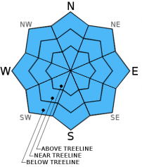
| Mid Slope Winds: | SW | SW | W |
| Wind Speed: | 20 to 25 mph with gusts to 40 mph. | 20 to 30 mph with gusts to 40 mph. | 15 to 25 mph with gusts to 35 mph. |
| Expected snowfall: | 0 | 0 to trace | Up to 2 |
For 8000 ft. to 9000 ft.
| Sunday | Sunday Night | Monday | |
|---|---|---|---|
| Weather: | Partly cloudy skies. | Partly cloudy skies becoming mostly cloudy. Isolated snow showers in the evening. Scattered snow showers after midnight. | Mostly cloudy skies with a chance of snow showers in the morning. Snow showers likely in the afternoon. |
| Temperatures: | 37 to 45 deg. F. | 16 to 23 deg. F. | 26 to 32 deg. F. |
| Ridge Top Winds: | W | W | W |
| Wind Speed: | 35 to 40 mph with gusts to 65 mph. | 35 to 45 mph with gusts to 65 mph. | 30 to 40 mph with gusts to 55 mph. |
| Expected snowfall: | 0 | 0 to trace | Up to 2 |


