THIS AVALANCHE FORECAST EXPIRED ON March 31, 2018 @ 6:57 am
Avalanche Forecast published on March 30, 2018 @ 6:57 am
Issued by Andy Anderson - Tahoe National Forest - Sierra Avalanche Center

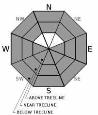
LOW avalanche danger this morning will quickly increase to MODERATE avalanche danger all elevations as the day warms up. Loose wet avalanche activity will become possible. 

2. Moderate

?

Above Treeline
Heightened avalanche conditions on specific terrain features. Evaluate snow and terrain carefully; identify features of concern.

2. Moderate

?

Near Treeline
Heightened avalanche conditions on specific terrain features. Evaluate snow and terrain carefully; identify features of concern.

2. Moderate

?

Below Treeline
Heightened avalanche conditions on specific terrain features. Evaluate snow and terrain carefully; identify features of concern.
    Heightened avalanche conditions on specific terrain features. Evaluate snow and terrain carefully; identify features of concern.
Avalanche Problem 1: Loose Wet
  • Type ?
  • Aspect/Elevation ?
  • Likelihood ?
    Certain
    Very Likely
    Likely
    Possible
    Unlikely
  • Size ?
    Historic
    Very Large
    Large
    Small

Another warm sunny day means loose wet avalanche activity will quickly become possible again today once last night's weak surface refreeze melts. Sun-exposed E-SE-S-SW-W aspects hold the best potential for loose wet avalanche activity, but some loose wet instability could also form on more northerly aspects where wet surface snow may form. Wet snow instabilities could include pinwheels, rollerballs, and loose wet avalanches. Some of the loose wet avalanches could involve enough snow to injure a person.

Wet sticky snow, boot-top-deep wet snow, active roller balls or pinwheels, and other loose wet avalanches can indicate increasing wet snow instability.  Once signs of wet snow exist, move to a colder more shaded aspect or lower angle slopes. Planning an early start and an early finish can help avoid loose wet avalanche issues. 

recent observations

* Observations yesterday from Mt. Judah (Donner Summit area) and Ralston Peak (Echo Summit area) found firm frozen surfaces on sun-exposed aspects in the morning that softened by 10 am. 

* Corn snow conditions existed on sun-exposed slopes between 8000 ft. and 7400 ft. on SE-S aspects on Judah by 10 am. Small skier triggered roller balls started to occur on these sun-exposed aspects by 10:30 am.

* Above 8000 ft. on Ralston the snowpack had not been through quite enough melt-freeze cycles for true corn snow conditions to form. Deep wet punchy snow existed on Ralston below 7500 ft. by mid-morning. 

Weather and CURRENT CONDITIONS
weather summary

Warm spring weather will continue through the weekend. Some cloud cover could start to build over the forecast area during the next 24 hours. By tomorrow the forecast calls for more cloudy skies and slightly cooler but still above average temperatures.

CONDITIONS ALONG THE SIERRA CREST BETWEEN 8200 FT. AND 9200 FT. IN THE LAST 24 HOURS
6am temperature: 37 to 42 deg. F.
Max. temperature: 48 to 55 deg. F.
Average ridgetop wind direction: NE to E
Average ridgetop wind speed: 5 to 15 mph
Maximum ridgetop wind gust: 35 mph
New snowfall: 0 inches
Total snow depth: 72 to 104 inches
Two-Day Mountain Weather Forecast Produced in partnership with the Reno NWS
For 7000 ft. to 8000 ft.
Friday Friday Night Saturday
Weather: Mostly sunny to partly cloudy Partly cloudy Mostly cloudy
Temperatures: 55 to 60 deg. F. 30 to 35 deg. F. 53 to 58 deg. F.
Mid Slope Winds: Variable West Variable
Wind Speed: Light 10 to 15 mph with gusts to 30 mph in the evening becoming light overnight Light
Expected snowfall: 0 0 0
For 8000 ft. to 9000 ft.
Friday Friday Night Saturday
Weather: Mostly sunny to partly cloudy Partly cloudy Mostly cloudy
Temperatures: 50 to 56 deg. F. 30 to 35 deg. F. 48 to 54 deg. F.
Ridge Top Winds: Southwest West West
Wind Speed: 10 to 15 mph with gusts to 25 mph 10 to 15 mph with gusts to 30 mph in the evening becoming light overnight 10 to 15 mph with gusts to 25 mph in the afternoon
Expected snowfall: 0 0 0
Disclaimer

This avalanche advisory is provided through a partnership between the Tahoe National Forest and the Sierra Avalanche Center. This advisory covers the Central Sierra Nevada Mountains between Yuba Pass on the north and Ebbetts Pass on the south. Click here for a map of the forecast area. This advisory applies only to backcountry areas outside established ski area boundaries. This advisory describes general avalanche conditions and local variations always occur. This advisory expires 24 hours after the posted time unless otherwise noted. The information in this advisory is provided by the USDA Forest Service who is solely responsible for its content.

For a recorded version of the Avalanche Advisory call (530) 587-3558 x258