THIS AVALANCHE FORECAST EXPIRED ON February 4, 2019 @ 6:58 am
Avalanche Forecast published on February 3, 2019 @ 6:58 am
Issued by Steve Reynaud - Tahoe National Forest

HIGH avalanche danger will continue as the next storm impacts the forecast region today and through tonight.  Very dangerous avalanche conditions will exist.  Travel in or near avalanche terrain is not recommended.

4. High

?

Above Treeline
Very dangerous avalanche conditions. Travel in avalanche terrain not recommended.

4. High

?

Near Treeline
Very dangerous avalanche conditions. Travel in avalanche terrain not recommended.

4. High

?

Below Treeline
Very dangerous avalanche conditions. Travel in avalanche terrain not recommended.
    Very dangerous avalanche conditions. Travel in avalanche terrain not recommended.
Avalanche Problem 1: Wind Slab
  • Type ?
  • Aspect/Elevation ?
  • Likelihood ?
    Certain
    Very Likely
    Likely
    Possible
    Unlikely
  • Size ?
    Historic
    Very Large
    Large
    Small

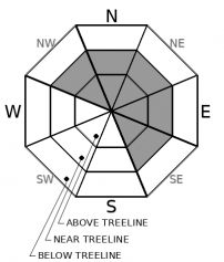
Wind slabs will be very likely on NW-N-NE-E-SE aspects in near and above treeline terrain due to strong to gale force SW winds and additional snowfall.  Existing wind slabs and cornices will remain fragile from yesterday and will continue to grow in size today and tonight.  Some wind slabs could form on other aspects or in below treeline terrain as wind speeds reach in excess of 100mph later today.  Large destructive wind slab avalanches could run down into below treeline terrain.  Travel in or near avalanche terrain is not recommended.

Avalanche Problem 2: Storm Slab
  • Type ?
  • Aspect/Elevation ?
  • Likelihood ?
    Certain
    Very Likely
    Likely
    Possible
    Unlikely
  • Size ?
    Historic
    Very Large
    Large
    Small

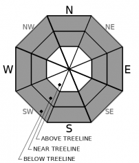
Storm slab avalanches will be very likely today and through the night on all aspects in near and below treeline terrain.  Increasing snowfall intensity throughout the day along with fluctuations in temperatures will create weaknesses within the storm snow.  Areas that have buried surface hoar below the recent storm snow could produce large avalanches that involve all the recent storm snow.  These avalanches could have wide propagation, be remotely triggered, and could occur below traditional ridgeline start zones.  Avoid avalanche run out zones and areas below steeper connected terrain.  

recent observations

*  2 small skier triggered storm slab avalanches were reported on Incline Lake Peak (Mt. Rose area) yesterday in near treeline terrain.  Snowpack tests also showed weakness within the new storm snow just above the old snow/new snow interface.

*  Small test slope wind slab avalanches were intentionally triggered by snowmobile near Jackson Meadows.  Wind loaded test slope was NE aspect at 7600'.  Heavy snow and wind transport was reported.

*  Observations on Hidden Peak (West Shore area) reported wet heavy snow at lower elevations below 8000' with much more snow, 12'' +, above 8000'.  Signs of instabilities were limited to above 8000' where wind transport was occurring.

*  Up to 2' of snow was reported in Hope Valley with S5 snowfall rates in the morning.  The buried surface hoar layer was found but was non-reactive at this location. 

Weather and CURRENT CONDITIONS
weather summary

Yesterday around 1 to 2' of new snow fell above 8000' with the southern half of the forecast area favored with higher snowfall totals.  Snow levels did not fall as quickly as expected with mostly wet and/or heavy snow accumulating below 7500'.  Snowfall will be on the increase this morning with around 1' or more of snow expected today above 7000'.  Snow levels may rise slightly today but are forecasted to drop down this evening to around 4000' as cold air moves into the area.  Tonight into Monday morning we could see 1 to 2' of new snow at lake level with 2 to 4' above 7000'.  Another colder storm follows on Monday night into Tuesday with an additional 1 to 2' of snow.  A break should develop sometime on Wednesday. 

CONDITIONS ALONG THE SIERRA CREST BETWEEN 8200 FT. AND 9200 FT. IN THE LAST 24 HOURS
6am temperature: 21 to 25 deg. F.
Max. temperature: 34 deg. F.
Average ridgetop wind direction: SW
Average ridgetop wind speed: 40 to 50 mph
Maximum ridgetop wind gust: 84 mph
New snowfall: 11 to 23 inches
Total snow depth: 75 to 95 inches
Two-Day Mountain Weather Forecast Produced in partnership with the Reno NWS
For 7000 ft. to 8000 ft.
Sunday Sunday Night Monday
Weather: Cloudy. Snow. Snow levels below 7000 feet. Chance of precipitation is 95%. Cloudy. Snow. Snow levels below 7000 feet. Chance of precipitation is 100%. Cloudy. Snow. Snow levels below 7000 feet. Chance of precipitation is 100%.
Temperatures: 31 to 36. deg. F. 21 to 26. deg. F. 26 to 31. deg. F.
Mid Slope Winds: Southwest 15 to 30 mph. Gusts up to 40 mph increasing to 55 mph in the afternoon. Southwest 20 to 35 mph with gusts to 65 mph. Southwest 20 to 35 mph with gusts to 70 mph.
Expected snowfall: 80% probability of 7 to 12 inches. 20% probability of 12 to 15 inches. | SWE = 0.50-0.75 inch. 70% probability of 12 to 20 inches. 30% probability of 21 to 29 inches. | SWE = 0.70-1.15 inches. 70% probability of 11 to 19 inches. 30% probability of 20 to 29 inches. | SWE = 0.60-1.10 inches.
For 8000 ft. to 9000 ft.
Sunday Sunday Night Monday
Weather: Cloudy. Snow. Snow levels below 7000 feet. Chance of precipitation is 95%. Cloudy. Snow. Snow levels below 7000 feet. Chance of precipitation is 100%. Cloudy. Snow. Snow levels below 7000 feet. Chance of precipitation is 100%.
Temperatures: 27 to 33. deg. F. 19 to 24. deg. F. 23 to 28. deg. F.
Ridge Top Winds: Southwest 30 to 45 mph with gusts to 80 mph. Southwest 30 to 45 mph increasing to 35 to 55 mph after midnight. Gusts up to 105 mph. Southwest 35 to 55 mph with gusts to 105 mph.
Expected snowfall: 80% probability of 9 to 12 inches. 20% probability of 12 to 18 inches. | SWE = 0.60-0.85 inch. 70% probability of 14 to 22 inches. 30% probability of 22 to 33 inches. | SWE = 0.80-1.30 inches. 70% probability of 12 to 24 inches. 30% probability of 24 to 32 inches. | SWE = up to 1.20 inches.
Disclaimer

This avalanche forecast is provided through a partnership between the Tahoe National Forest and the Sierra Avalanche Center. This forecast covers the Central Sierra Nevada Mountains between Yuba Pass on the north and Ebbetts Pass on the south. Click here for a map of the forecast area. This forecast applies only to backcountry areas outside established ski area boundaries. This forecast describes general avalanche conditions and local variations always occur. This forecast expires 24 hours after the posted time unless otherwise noted. The information in this forecast is provided by the USDA Forest Service who is solely responsible for its content.

For a recorded version of the avalanche forecast call (530) 587-3558 x258