THIS AVALANCHE FORECAST EXPIRED ON March 22, 2019 @ 6:59 am
Avalanche Forecast published on March 21, 2019 @ 6:59 am
Issued by Andy Anderson - Tahoe National Forest - Sierra Avalanche Center

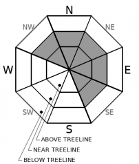
MODERATE avalanche danger may still exist in near and above treeline terrain due to the possibility of lingering wind slab problems. Human triggered avalanches may remain possible today. 

2. Moderate

?

Above Treeline
Heightened avalanche conditions on specific terrain features. Evaluate snow and terrain carefully; identify features of concern.

2. Moderate

?

Near Treeline
Heightened avalanche conditions on specific terrain features. Evaluate snow and terrain carefully; identify features of concern.

1. Low

?

Below Treeline
Generally safe avalanche conditions. Watch for unstable snow on isolated terrain features.
    Heightened avalanche conditions on specific terrain features. Evaluate snow and terrain carefully; identify features of concern.
Avalanche Problem 1: Wind Slab
  • Type ?
  • Aspect/Elevation ?
  • Likelihood ?
    Certain
    Very Likely
    Likely
    Possible
    Unlikely
  • Size ?
    Historic
    Very Large
    Large
    Small

Some slabs of wind drifted snow formed on leeward slopes as a result of recent snow and wind. These small wind slabs should be more difficult to trigger today as the new snow settles and bonds to the snow below it. Still, a human-triggered avalanche may remain possible especially in complex or extreme terrain (like couloirs, cliffy areas, unsupported slopes, and steep convex rollovers) or on a heavily wind-loaded slope. Most of these wind slabs should remain small, but an avalanche large enough to have serious consequences is not impossible. 

Look for clues like cornices above a slope, drifted snow, or wind created surface textures to help identify where lingering wind slabs may exist. Some of these may be covered with a small amount of new snow making them more difficult to identify. Smooth slopes without previous tracks in sheltered areas may provide more consistent recreation conditions.

recent observations

* Wind slabs were reported on Castle Peak, Rubicon Peak, and Tamarack Peak yesterday. These remained mostly small and limited to areas near ridgelines. A ski cut on a test slope on Castle Peak produced a small slab failure that started as more of a loose wet sluff and then broke more like a slab once the skier reached a convex rollover. Ski cuts also released a very small pocket of wind-loaded snow on Rubicon. Ski kicks and cuts produced cracking on wind-loaded test slopes in all three areas.

* Wet sticky snow existed in some places in all three areas. On Rubicon, it was limited to below 8000 ft; on Castle, it was more widespread; and on Tamarack, it formed on slopes that received a small amount of sun in the afternoon. 

* A refreezing crust existed below the new snow. At lower elevations, it remained soft. At upper elevations, it was firmer and more supportable.

Weather and CURRENT CONDITIONS
weather summary

Light snow showers should continue today as a low-pressure system moves through the area. This low pressure should depart the area this afternoon leaving unsettled but drier weather in its wake. Forecasted cloud cover and cooler temperatures should prevent much daytime warming from occurring today. Another small system should arrive over the region by tomorrow afternoon bringing more snow showers and some increased winds through Saturday. 

CONDITIONS ALONG THE SIERRA CREST BETWEEN 8200 FT. AND 9200 FT. IN THE LAST 24 HOURS
6am temperature: 22 to 27 deg. F.
Max. temperature: 27 to 32 deg. F.
Average ridgetop wind direction: SW
Average ridgetop wind speed: 15 to 20 mph
Maximum ridgetop wind gust: 54 mph
New snowfall: 1 to 4 inches
Total snow depth: 112 to 159 inches
Two-Day Mountain Weather Forecast Produced in partnership with the Reno NWS
For 7000 ft. to 8000 ft.
Thursday Thursday Night Friday
Weather: Mostly cloudy. Scattered snow showers in the morning, then chance of snow showers in the afternoon. Snow levels below 7000 feet. Chance of precipitation is 40%. Mostly cloudy then becoming partly cloudy. Slight chance of snow showers in the evening. Snow levels below 7000 feet. Chance of precipitation is 15%. Sunny then becoming mostly cloudy. Chance of snow showers in the afternoon. Snow levels below 7000 feet. Chance of precipitation is 25%.
Temperatures: 34 to 39 deg. F. 19 to 25 deg. F. 36 to 42 deg. F.
Mid Slope Winds: Light winds. Light winds. Light winds becoming southwest around 15 mph in the afternoon. Gusts up to 25 mph.
Expected snowfall: Up to 1 inch. | SWE = less than 0.10 inch. No accumulation. . | SWE = trace amounts. Up to 1 inch. | SWE = less than 0.10 inch.
For 8000 ft. to 9000 ft.
Thursday Thursday Night Friday
Weather: Mostly cloudy. Scattered snow showers in the morning, then chance of snow showers in the afternoon. Snow levels below 7000 feet. Chance of precipitation is 45%. Mostly cloudy then becoming partly cloudy. Slight chance of snow showers in the evening. Snow levels below 7000 feet. Chance of precipitation is 15%. Sunny then becoming mostly cloudy. Chance of snow showers in the afternoon. Snow levels below 7000 feet. Chance of precipitation is 25%.
Temperatures: 30 to 36 deg. F. 16 to 21 deg. F. 32 to 38 deg. F.
Ridge Top Winds: Light winds. West around 15 mph with gusts to 25 mph. Southwest 15 to 25 mph. Gusts up to 30 mph increasing to 40 mph in the afternoon.
Expected snowfall: Up to 1 inch. | SWE = less than 0.10 inch. No accumulation. | SWE = trace amounts. Up to 2 inches. | SWE = less than 0.10 inch.
Disclaimer

This avalanche forecast is provided through a partnership between the Tahoe National Forest and the Sierra Avalanche Center. This forecast covers the Central Sierra Nevada Mountains between Yuba Pass on the north and Ebbetts Pass on the south. Click here for a map of the forecast area. This forecast applies only to backcountry areas outside established ski area boundaries. This forecast describes general avalanche conditions and local variations always occur. This forecast expires 24 hours after the posted time unless otherwise noted. The information in this forecast is provided by the USDA Forest Service who is solely responsible for its content.

For a recorded version of the avalanche forecast call (530) 587-3558 x258