THIS AVALANCHE FORECAST EXPIRED ON February 14, 2020 @ 6:50 am
Avalanche Forecast published on February 13, 2020 @ 6:50 am
Issued by Brandon Schwartz - Tahoe National Forest

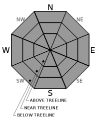
Snow surface melt could allow for small areas of loose wet instabilities to form on slopes with direct sun exposure during the afternoon hours. Areas of very firm snow surfaces exist with a potential sliding fall hazard. LOW avalanche danger exists with normal caution advised.

1. Low

?

Above Treeline
Generally safe avalanche conditions. Watch for unstable snow on isolated terrain features.

1. Low

?

Near Treeline
Generally safe avalanche conditions. Watch for unstable snow on isolated terrain features.

1. Low

?

Below Treeline
Generally safe avalanche conditions. Watch for unstable snow on isolated terrain features.
    Generally safe avalanche conditions. Watch for unstable snow on isolated terrain features.
Avalanche Problem 1: Normal Caution
  • Type ?
  • Aspect/Elevation ?
  • Likelihood ?
    Certain
    Very Likely
    Likely
    Possible
    Unlikely
  • Size ?
    Historic
    Very Large
    Large
    Small

A decent to strong snow surface refreeze is expected to have occurred last night with near to below freezing air temperatures and clear skies. Warming air temperatures and light winds this morning will allow for snow surface melt on E-SE-S-SW-W aspects as the day progresses. Anticipate firm snow surface conditions prior to the onset of melt mid to late morning. Some small areas of loose wet instabilities could form this afternoon but are not expected to present a significant hazard to backcountry travelers.

Sliding falls on firm snow surfaces remain a concern. While conditions will gradually soften in areas of direct sun exposure, previously wind scoured NW-N-NE aspects will remain firm all day. Incorporate how to manage the hazard associated with travel on firm snow surfaces into today's travel plan. It would be easy to get into an undesirable position on steep terrain under the current conditions.

recent observations

* Observations yesterday from travel on E-SE-S aspects in the Carson Pass and Mount Rose regions reported firm conditions in the morning that gave way to snow surface melt during the late morning and midday hours.

* NW-N-NE aspects near treeline and above treeline are heavily wind scoured and firm in many areas.

* Some areas of soft, unconsolidated surface snow exist in wind protected areas on northerly aspects.

Weather and CURRENT CONDITIONS
weather summary

Another round of sunny skies and above freezing air temperatures is expected today. A weak air temperature inversion set up overnight with 20s on the mountain valley floors and low to mid 30s at the mid and upper elevations. Ridgetop winds shifted to the SW early this morning with light to moderate speeds forecast. Friday morning is expected to start out much the same, with some mid and high level cloud cover filling in during the afternoon hours. A weather system passing by mostly to the north is expected to affect the forecast area Saturday afternoon into Sunday.

CONDITIONS ALONG THE SIERRA CREST BETWEEN 8200 FT. AND 9200 FT. IN THE LAST 24 HOURS
6am temperature: 30 to 36 deg. F.
Max. temperature: 36 to 42 deg. F.
Average ridgetop wind direction: NE
Average ridgetop wind speed: 23 mph
Maximum ridgetop wind gust: 47 mph
New snowfall: 0 inches
Total snow depth: 41 to 51 inches
Two-Day Mountain Weather Forecast Produced in partnership with the Reno NWS
For 7000 ft. to 8000 ft.
Thursday Thursday Night Friday
Weather: Sunny skies. Chance of precipitation is 0%. Clear skies. Chance of precipitation is 0%. Sunny then becoming partly cloudy. Chance of precipitation is 5%.
Temperatures: 44 to 49. deg. F. 21 to 26. deg. F. 43 to 48. deg. F.
Mid Slope Winds: Light winds. Gusts up to 25 mph in the afternoon. Southwest around 15 mph with gusts to 30 mph. Light winds.
Expected snowfall: No accumulation. | SWE = none. No accumulation. | SWE = none. No accumulation. | SWE = none.
For 8000 ft. to 9000 ft.
Thursday Thursday Night Friday
Weather: Sunny skies. Chance of precipitation is 0%. Clear skies. Chance of precipitation is 0%. Sunny then becoming partly cloudy. Chance of precipitation is 5%.
Temperatures: 39 to 45. deg. F. 19 to 24. deg. F. 38 to 44. deg. F.
Ridge Top Winds: Light winds becoming southwest around 15 mph with gusts to 25 mph in the afternoon. Southwest around 15 mph with gusts to 30 mph. Southwest around 15 mph with gusts to 30 mph.
Expected snowfall: No accumulation. | SWE = none. No accumulation. | SWE = none. No accumulation. | SWE = none.
Disclaimer

This avalanche forecast is provided through a partnership between the Tahoe National Forest and the Sierra Avalanche Center. This forecast covers the Central Sierra Nevada Mountains between Yuba Pass on the north and Ebbetts Pass on the south. Click here for a map of the forecast area. This forecast applies only to backcountry areas outside established ski area boundaries. This forecast describes general avalanche conditions and local variations always occur. This forecast expires 24 hours after the posted time unless otherwise noted. The information in this forecast is provided by the USDA Forest Service who is solely responsible for its content.

For a recorded version of the avalanche forecast call (530) 587-3558 x258