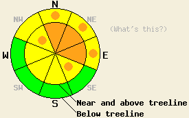
This Avalanche Advisory was published on December 19, 2008:

|
December 19, 2008 at 8:11 am |
|
Near and above treeline the avalanche danger is CONSIDERABLE on N-NE-E aspects with pockets of CONSIDERABLE danger on NW and SE aspects steeper than 32 degrees. Below treeline the avalanche danger is MODERATE with pockets of CONSIDERABLE on NW-N-NE-E aspects steeper than 32 degrees. Variability in distribution and type of weak layers makes the avalanche danger more uncertain and requires extra caution. |
|
|
|
Forecast Discussion:
Overnight snowfall across the forecast area ranged from 8 to 12 inches along the Sierra Crest north of Highway 50, 8 inches in the Mount Rose area, and 2 to 4 inches south of Highway 50 along the Crest and in the southern Carson Range. Since 5pm yesterday, the ridge top winds have averaged between 80 and 100 mph with gusts as high as 140 mph. Even though the snowfall and winds should decrease today as the storm system moves off to the east, some snow showers should persist through tomorrow. The next storm system comes more from the southwest and should cause temperatures and snow levels to rise Saturday night as it impacts the area with more wind and snow.
As the winds shifted back to the southwest yesterday, they re-transported snow and began to form stiff wind slabs on leeward slopes. Yesterday morning observations from protected areas on Incline Lake Peak showed a mostly stable snowpack with minimal slab formation. By mid afternoon observations from Rubicon Peak and the Grouse Rock area showed that small, isolated pockets of newly formed wind slabs on steep test slopes began to crack. Observations in these areas showed a variety of weak layers still present in the snowpack: the 11/26 facet layer, some surface hoar persisting in more protected areas, and a density change between the newly formed wind slabs and the previous storm snow. The variability in distribution and type of weak layers makes the avalanche danger more uncertain and requires extra caution. Snowpit tests indicated that fracture initiation and propagation were becoming more likely on all of these layers as the new slab grew. Last night's high winds and new snow loaded the leeward slopes even more. These wind slabs will grow in depth and extent today as more snow and wind impact the forecast area.
The primary avalanche concern today will be these wind slabs. Natural avalanches involving these slabs due to failure of any of the weak layers mentioned above are possible and human triggering of these avalanches is probable. These avalanches could involve large amounts of snow and collisions with large immovable objects like rocks and trees. Both of these factors increase the consequences of being caught in a slide. Today, the most avalanche prone slopes will be the wind loaded N-NE-E slopes near and above treeline. However, these strong winds will cause wind loading and cross loading in traditionally protected areas and farther downslope today. Be aware of any signs of wind loading like drifting, wind features on the snow surface, blowing snow, etc and use these signs to determine which slopes have been wind loaded. Expect to see some wind slab development below treeline on leeward slopes as well. South of Highway 50 where less snow has accumulated expect the danger to be slightly lower.
The bottom line:
Near and above treeline the avalanche danger is CONSIDERABLE on N-NE-E aspects with pockets of CONSIDERABLE danger on NW and SE aspects steeper than 32 degrees. Below treeline the avalanche danger is MODERATE with pockets of CONSIDERABLE on NW-N-NE-E aspects steeper than 32 degrees. Variability in distribution and type of weak layers makes the avalanche danger more uncertain and requires extra caution.
Weather Observations from along the Sierra Crest between 8200 ft and 8800 ft:
| 0600 temperature: | 20 deg. F. |
| Max. temperature in the last 24 hours: | 24 deg. F. |
| Average wind direction during the last 24 hours: | Southwest |
| Average wind speed during the last 24 hours: | 65-75 mph |
| Maximum wind gust in the last 24 hours: | 140 mph |
| New snowfall in the last 24 hours: | north of Hwy 50 8 -12 inches and south of Hwy 50 2-4 inches |
| Total snow depth: | 36 inches |
Two-Day Mountain Weather Forecast - Produced in partnership with the Reno NWS
For 7000-8000 ft: |
|||
| Friday: | Friday Night: | Saturday: | |
| Weather: | Mostly cloudy with snow showers. | Mostly cloudy. | Mostly cloudy. |
| Temperatures: | 20-27 deg. F. | 6-13 deg. F. | 21-28 deg. F. |
| Wind direction: | Southwest | Southwest | Variable |
| Wind speed: | 30-45 mph with gusts to 60 mph decreasing to 20-30 mph with gusts to 45 in the afternoon. | 10-20 mph with gusts to 40 mph decreasing to 25 mph after midnight | Light |
| Expected snowfall: | 3-5 in. | O in. | O in. |
For 8000-9000 ft: |
|||
| Friday: | Friday Night: | Saturday: | |
| Weather: | Mostly cloudy with snow showers. | Mostly cloudy. | Mostly cloudy. |
| Temperatures: | 14-21 deg. F. | 8-15 deg. F. | 19-26 deg. F. |
| Wind direction: | Southwest | North | North |
| Wind speed: | 50-75 mph with gusts to 125 mph decreasing to 35-45 mph with gusts to 80 mph this afternoon. | 25-45 mph with gusts to 80 mph | 20-30 mph with gusts to 60 mph |
| Expected snowfall: | 4-8 in. | O in. | O in. |


