In partnership with: 
|
December 22, 2008 at 7:54 am |
|
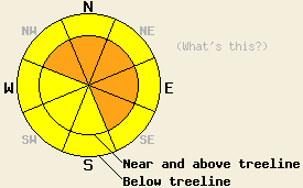
Near and above treeline, avalanche danger is CONSIDERABLE on NW-N-NE-E-SE aspects, 35 degrees and steeper. Below treeline, avalanche danger is MODERATE in open areas 37 degrees and steeper. |
|
|
|
A cold front passed through the forecast area last night, lowering snow levels from yesterday's 6,000' to around 3,000' this morning. Air temperatures fell sharply after midnight. Ridgetop winds out of the west southwest have remained strong this morning. Storm totals are running 12 to 13 inches along the Sierra Crest and 5 to 8 inches in the Mount Rose area.
The current storm system began warm and has become progressively colder. Observations made yesterday near Yuba Pass indicated good bonding of new snow to the old snow surface. This was also observed this morning at the Alpine Meadows snow study plot. Recent observations from Yuba Pass, Donner Summit, and the Mount Rose area all indicate that the existing snowpack is in good condition to handle new snow loading from this type of storm.
Today, avalanche activity that occurs is expected to have a failure layer within the new snow. Observations this morning from the snow study plot at Alpine Meadows (6,800') indicate several clean and easy shears (Q1) exist within the new snow. Needle and rimed stellar snow crystals have been identified as the failure layers. Instability on these snow crystals is expected to last through the day today.
Human triggered and possibly natural avalanches that are large enough to bury a person are expected today, especially along the Sierra Crest where more new snow has accumulated. Steep wind loaded areas, mainly near and above treeline on NW-N-NE-E-SE aspects are the most likely location for larger avalanches to occur today. Below treeline, human triggered avalanches are possible today in steep open areas with snowpack failure expected to occur within the new snow.
The bottom line:
Near and above treeline, avalanche danger is CONSIDERABLE on NW-N-NE-E-SE aspects, 35 degrees and steeper. Below treeline, avalanche danger is MODERATE in open areas 37 degrees and steeper.
Near and above treeline, avalanche danger is CONSIDERABLE on NW-N-NE-E-SE aspects, 35 degrees and steeper. Below treeline, avalanche danger is MODERATE in open areas 37 degrees and steeper.
| 0600 temperature: | 15 deg. F. |
| Max. temperature in the last 24 hours: | 29 deg. F. |
| Average wind direction during the last 24 hours: | West Southwest |
| Average wind speed during the last 24 hours: | 51 mph |
| Maximum wind gust in the last 24 hours: | 108 mph |
| New snowfall in the last 24 hours: | 5 to 13 inches |
| Total snow depth: | 35 to 45 inches |
For 7000-8000 ft: |
|||
| Monday: | Monday Night: | Tuesday: | |
| Weather: | Continued snow decreasing to snow showers. | Snow showers. | Cloudy with a slight chance of snow showers. |
| Temperatures: | 19 to 26 deg. F. | 10 to 17 deg. F. | 21 to 28 deg. F. |
| Wind direction: | W | NW | W |
| Wind speed: | 15 to 25 mph with gusts to 45 mph, decreasing to 35 mph in the afternoon. | 10 to 15 mph with gusts to 35 mph. | 10 to 15 mph with gusts to 25 mph in the morning. |
| Expected snowfall: | 1 to 3 in. | 1 to 4 in. | 0 to 1 in. |
For 8000-9000 ft: |
|||
| Monday: | Monday Night: | Tuesday: | |
| Weather: | Continued snow decreasing to snow showers. | Snow showers. | Cloudy with a slight chance of snow showers. |
| Temperatures: | 16 to 23 deg. F. | 5 to 12 deg. F. | 14 to 21 deg. F. |
| Wind direction: | W | NW | W |
| Wind speed: | 30 to 45 mph with gusts to 65 mph, decreasing to 20 to 30 mph with gusts to 50 mph in the afternoon. | 15 to 25 mph with gusts to 45 mph. | 10 to 20 mph with gusts to 35 mph in the morning. |
| Expected snowfall: | 1 to 4 in. | 2 to 5 in. | 0 to 1 in. |


This website is owned and maintained by the non-profit arm of the Sierra Avalanche Center. Some of the content is updated by the USDA avalanche forecasters including the forecasts and some observational data. The USDA is not responsible for any advertising, fund-raising events/information, or sponsorship information, or other content not related to the forecasts and the data pertaining to the forecasts.

