In partnership with: 
|
December 24, 2008 at 8:04 am |
|
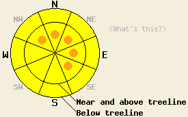
The avalanche danger is LOW this morning. It will increase due to new snow and wind today. Near and above treeline the avalanche danger will increase to MODERATE with pockets of CONSIDERABLE on NW-N-NE-E-SE slopes steeper than 35 degrees. Below treeline the avalanche danger will increase to MODERATE on open slopes steeper than 35 degrees. The avalanche danger will continue to rise overnight. |
|
|
|
The first of two storms started to affect the forecast area this morning with snow and an increase in southwest winds. This storm will add moisture to the next storm that is expected to arrive tonight. Snow levels should rise slightly this evening between the two systems before falling quickly back below 5000'. Combined these storms could bring 2 to 4 feet of new snow to the forecast area above 7000'. The most intense snow fall should occur tonight north of Highway 50. The winds will continue to increase and should peak overnight with sustained winds over 70 mph and ridgetop gusts at 140 mph.
Yesterday, observations from the Carson Pass area, the Mt. Judah area, and the Mt. Rose area all showed low density new snow sitting on top of a stiff wind slab that formed on Dec. 22. In all three of these areas the low density new snow did not form a slab layer. Snowpit tests revealed weak bonding between this new snow and the 12/22 wind slab. Due to the lack of slab formation this weakness mostly just resulted in sluffing of the new snow on steep slopes. These snowpit tests also showed that some older deeper weak layers still exist. A few very small inconsequential natural avalanches (small D1's) occurred in the Carson Pass area in pockets of heavily wind loaded N-NE slopes above treeline very early Tuesday morning.
Wind transport of both the existing snow and today's new slightly heavier snow should form heavy wind slabs on top of the light snow from yesterday. These newly formed wind slabs will be the primary avalanche concern today. As these wind slabs grow in depth and extent today and tomorrow, avalanche activity will become more likely. Avalanches will also grow in size as the wind slabs expand. By tonight some avalanches could begin stepping down to the older weak layers after initiating in storm snow weaknesses or the interface between yesterday's low density snow and today's new snow. These avalanches could involve large amounts of snow and would have serious consequences.
Today human triggered avalanches will become possible on newly wind loaded NW-N-NE-E-SE aspects steeper than 35 degrees by this afternoon. Some areas where natural avalanche activity is possible may form on the most heavily wind loaded slopes. Natural avalanches should become more widespread overnight as more snow and wind create larger, heavier wind slabs.
The avalanche danger is LOW this morning. It will increase due to new snow and wind today. Near and above treeline the avalanche danger will increase to MODERATE with pockets of CONSIDERABLE on NW-N-NE-E-SE slopes steeper than 35 degrees. Below treeline the avalanche danger will increase to MODERATE on open slopes steeper than 35 degrees. The avalanche danger will continue to rise overnight.
| 0600 temperature: | 19 deg. F. |
| Max. temperature in the last 24 hours: | 21 deg. F. |
| Average wind direction during the last 24 hours: | Southwest |
| Average wind speed during the last 24 hours: | 25-35 mph |
| Maximum wind gust in the last 24 hours: | 59 mph |
| New snowfall in the last 24 hours: | O inches |
| Total snow depth: | 42-48 inches |
For 7000-8000 ft: |
|||
| Wednesday: | Wednesday Night: | Thursday: | |
| Weather: | Snow. | Snow. | Snow tapering off to showers in the afternoon. |
| Temperatures: | 23-30 deg. F. | 12-19 deg. F. | 15-22 deg. F. |
| Wind direction: | Southwest | Southwest | Southwest shifting to the west |
| Wind speed: | 10-15 mph with gusts to 30 mph in the morning increasing to 20-30 mph with gusts to 50 mph this afternoon. | 30-45 mph with gusts to 70 mph decreasing to gusts to 45 mph after midnight. | 20-30 mph with gusts to 45 mph decreasing to 15-20 mph with gusts to 30 mph in the afternoon. |
| Expected snowfall: | 6-10 in. | 10-18 in. | 4-8 in. |
For 8000-9000 ft: |
|||
| Wednesday: | Wednesday Night: | Thursday: | |
| Weather: | Snow. | Snow. | Snow tapering off to showers in the afternoon. |
| Temperatures: | 20-27 deg. F. | 10-18 deg. F. | 14-20 deg. F. |
| Wind direction: | Southwest | Southwest | Southwest |
| Wind speed: | 20-30 mph with gusts to 65 mph increasing to 45-60 mph with gusts to 100 mph this afternoon. | 60-75 mph with gusts to 140 mph. | 40-60 mph with gusts to 105 mph decreasing to 30-40 mph with gusts to 75 mph in the afternoon. |
| Expected snowfall: | 8-14 in. | 12-20 in. | 5-10 in. |


This website is owned and maintained by the non-profit arm of the Sierra Avalanche Center. Some of the content is updated by the USDA avalanche forecasters including the forecasts and some observational data. The USDA is not responsible for any advertising, fund-raising events/information, or sponsorship information, or other content not related to the forecasts and the data pertaining to the forecasts.

