In partnership with: 
|
December 27, 2008 at 7:57 am |
|
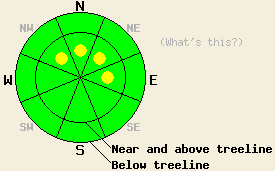
Near and above treeline, avalanche danger is LOW with pockets of MODERATE danger on NW-N-NE-E aspects, 37 degrees and steeper. Below treeline, avalanche danger is LOW. |
|
|
|
An air temperature inversion has built into the forecast area overnight, causing warmer air temperatures at mountain top levels than down in the valleys. Ridgetop winds have shifted from northeast to west overnight and have remained light. Air temperatures today are expected to warm to near freezing at the 7,000' level.
Yesterday, observations made on Hidden Peak (West Shore Lake Tahoe) noted many point release avalanches from 12/25 in near and above treeline areas on steep N-NE-E aspects of Hidden Peak, Rubicon Peak, and on several peaks in the Desolation Wilderness. A snowpit was dug below treeline on Hidden Peak at 8,230' in a slightly wind affected 34 degree NE aspect open area. Stability tests indicated that the potential for fracture propagation still existed if hard force was applied to the snowpack (Ectp-21 Q3). Snowpack failure occurred within the top 8 to 12 inches of the snowpack. Additionally, light NE winds were observed to slightly stiffen surface snow above treeline on N-NE-E aspects in the area. Plumes of blowing snow were observed looking into the Desolation Wilderness at Dick's Peak.
Today, continued settlement and bonding within the recent storm snow will provide most areas with a stable snowpack. Within areas that generally seem stable, some isolated slabs will exist near and above treeline on steep NW-N-NE-E aspects. The characteristics of these slabs were enhanced by yesterday's light NE winds and may fail in response to human triggers. Any avalanche activity today is expected to be isolated and occur in wind affected areas. Anticipated depth of any slab failure is within the top 1 foot or so of the snowpack. Use good travel habits to minimize risk.
Near and above treeline, avalanche danger is LOW with pockets of MODERATE danger on NW-N-NE-E aspects, 37 degrees and steeper. Below treeline, avalanche danger is LOW.
| 0600 temperature: | 19 deg. F. |
| Max. temperature in the last 24 hours: | 20 deg. F. |
| Average wind direction during the last 24 hours: | Northeast shifting to west. |
| Average wind speed during the last 24 hours: | 17 mph |
| Maximum wind gust in the last 24 hours: | 35 mph |
| New snowfall in the last 24 hours: | O inches |
| Total snow depth: | 50 to 60 inches |
For 7000-8000 ft: |
|||
| Saturday: | Saturday Night: | Sunday: | |
| Weather: | Cloudy with a slight chance of snow showers. | Cloudy with a chance of snow showers. | Mostly cloudy with a chance of snow showers. |
| Temperatures: | 25 to 32 deg. F. | 16 to 23 deg. F. | 34 to 40 deg. F. |
| Wind direction: | NW | SW | SW |
| Wind speed: | Up to 10 mph | Around 10 mph | 10 to 15 mph with gusts to 30 mph. |
| Expected snowfall: | 0 to trace in. | 0 to trace in. | 0 to trace in. |
For 8000-9000 ft: |
|||
| Saturday: | Saturday Night: | Sunday: | |
| Weather: | Cloudy with a slight chance of snow showers. | Cloudy with a chance of snow showers. | Mostly cloudy with a chance of snow showers. |
| Temperatures: | 22 to 29 deg. F. | 16 to 23 deg. F. | 31 to 37 deg. F. |
| Wind direction: | NW | W | W |
| Wind speed: | 10 to 15 mph with gusts to 25 mph, increasing to 35 mph in the afternoon. | 20 to 30 mph with gusts to 45 mph. | 20 to 30 mph with gusts to 45 mph. |
| Expected snowfall: | 0 to trace in. | 0 to trace in. | 0 to trace in. |


This website is owned and maintained by the non-profit arm of the Sierra Avalanche Center. Some of the content is updated by the USDA avalanche forecasters including the forecasts and some observational data. The USDA is not responsible for any advertising, fund-raising events/information, or sponsorship information, or other content not related to the forecasts and the data pertaining to the forecasts.

