In partnership with: 
|
December 28, 2008 at 7:48 am |
|
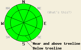
Avalanche danger is LOW for all elevations and aspects. Human triggered avalanches are unlikely but not impossible today. Very isolated areas of instability may exist. |
|
|
|
A storm system passing to the north will continue to bring clouds, wind, and little to no precipitation to the forecast area. Ridgetop winds have been moderate in speed, generally from the west yesterday, overnight, and into this morning. Air temperatures at all elevations are in the upper 20s to low 30s deg. F this morning. Air temperatures are expected to rise above freezing today in most areas below 8,500'.
Yesterday, observations made on Tamarack Peak (Mount Rose area) showed significant blowing snow. Wind loading in lee areas, mainly on E-SE aspects created stable slabs on the local terrain. A variety of stability tests on 30 to 35 degree wind loaded slopes gave no evidence of instability. No steeper slopes were available for testing in the immediate area. Observations made on the north side of Castle Peak (Donner Summit area) also indicated a generally stable snowpack. One outlying stability test found a clean, moderate force shear (CT-14 Q1) at 8,776' on a north aspect, 38 degree wind affected slope. The failure layer was 38cm (~15 inches) below the snow surface and identified as .5 - 1mm faceted snow crystals.
Today, a generally stable snowpack exists in most areas. A very isolated human triggered avalanche is not impossible near and above treeline on wind affected slopes that are 37 degrees or steeper. This would likely involve a higher density soft slab or possibly a hard slab failing 1 to 3 feet deep in the snowpack. If this occurs it is likely to catch a party by surprise due to otherwise widespread stable conditions. Use good travel habits to minimize risk.
Avalanche danger is LOW for all elevations and aspects. Human triggered avalanches are unlikely but not impossible today. Very isolated areas of instability may exist.
| 0600 temperature: | 28 deg. F. |
| Max. temperature in the last 24 hours: | 28 deg. F. |
| Average wind direction during the last 24 hours: | West |
| Average wind speed during the last 24 hours: | 25 mph |
| Maximum wind gust in the last 24 hours: | 48 mph |
| New snowfall in the last 24 hours: | O inches |
| Total snow depth: | 60 to 70 inches |
For 7000-8000 ft: |
|||
| Sunday: | Sunday Night: | Monday: | |
| Weather: | Cloudy with a chance of snow. | Mostly cloudy with a slight chance of snow. | Mostly cloudy with a slight chance of snow. |
| Temperatures: | 34 to 40 deg. F. | 20 to 27 deg. F. | 31 to 38 deg. F. |
| Wind direction: | W | SW | W |
| Wind speed: | 10 to 15 with gusts to 30 mph. | 10 to 15 mph with gusts to 25 mph in the evening. | 10 to 15 mph with gusts to 25 mph. |
| Expected snowfall: | 0 to trace in. | 0 to trace in. | 0 to trace in. |
For 8000-9000 ft: |
|||
| Sunday: | Sunday Night: | Monday: | |
| Weather: | Cloudy with a chance of snow. | Mostly cloudy with a slight chance of snow. | Mostly cloudy with a slight chance of snow. |
| Temperatures: | 31 to 37 deg. F. | 19 to 26 deg. F. | 28 to 35 deg. F. |
| Wind direction: | W | W | W |
| Wind speed: | 20 to 30 mph with gusts to 45 mph. | 15 to 25 mph with gusts to 40 mph. | 20 to 30 mph with gusts to 45 mph. |
| Expected snowfall: | 0 to trace in. | 0 to trace in. | 0 to trace in. |


This website is owned and maintained by the non-profit arm of the Sierra Avalanche Center. Some of the content is updated by the USDA avalanche forecasters including the forecasts and some observational data. The USDA is not responsible for any advertising, fund-raising events/information, or sponsorship information, or other content not related to the forecasts and the data pertaining to the forecasts.

