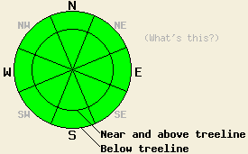
This Avalanche Advisory was published on December 29, 2008:

|
December 29, 2008 at 8:00 am |
|
The avalanche danger is LOW for all elevations and aspects. Human triggered avalanches are unlikely but not impossible today. Isolated areas of instability may exist. |
|
|
|
Forecast Discussion:
A strong low pressure system passing through the Pacific Northwest should brush the northern edge of the forecast area today. The southwest winds have increased and should continue through tonight as a result of this system. This low pressure should also cause some clouds across the forecast area today. A high pressure ridge following this system should bring increasing temperatures, clearer skies, and decreasing winds to the area over the next few days.
Yesterday observations from Jeanene's Peak in the Desolation Wilderness found some hard wind slabs on NE aspects above treeline. A thin, breakable sun crust has formed on the southerly aspects. Below the ridge lines unconsolidated snow still exists on most northerly aspects. Small point releases and and pinwheeling snow occurred on sun-exposed southerly slopes during the day. Observers saw similar conditions in the Mount Rose area. Snowpit tests in the Mount Rose area still find older weak layers in the snowpack.
Today's backcountry conditions today should be similar to yesterday's. The sun crusts should continue to form. Northerly aspects should continue to hold unconsolidated snow. Hard wind slabs will persist above treeline in some areas. Even though the winds have increased today, wind transport and new wind loading should be limited due to the melt-freeze crust on the southerly aspects. Like yesterday, dangerous avalanche activity is unlikely but not impossible today.
Today's first avalanche concern will be small point releases and pinwheels on southerly aspects due to daytime warming. These instabilities should be less widespread and smaller than they were yesterday and should not pose much of a threat to backcountry travelers. They could be enough to knock a person off balance. If that person is standing in a dangerous spot like the edge of a cliff these small instabilities could result in serious consequences.
The second avalanche concern today is isolated dense wind slabs near and above treeline on wind affected slopes that are 37 degrees or steeper. Even though these slabs should be hard to trigger and are unlikely to produce avalanches today, there is a small chance that the right trigger in the right spot could result in very isolated human-triggered slab avalanches. These unlikely avalanches warrant concern because they could involve dense wind slabs failing 1 to 3 feet deep in the snowpack. They would be a surprise to the person who triggers them due to otherwise widespread stable conditions. Use good travel habits to minimize these risks.
The bottom line:
The avalanche danger is LOW for all elevations and aspects. Human triggered avalanches are unlikely but not impossible today. Isolated areas of instability may exist.
Weather Observations from along the Sierra Crest between 8200 ft and 8800 ft:
| 0600 temperature: | 27 deg. F. |
| Max. temperature in the last 24 hours: | 32 deg. F. |
| Average wind direction during the last 24 hours: | Southwest |
| Average wind speed during the last 24 hours: | 30 mph |
| Maximum wind gust in the last 24 hours: | 58 mph |
| New snowfall in the last 24 hours: | O inches |
| Total snow depth: | 60-70 inches |
Two-Day Mountain Weather Forecast - Produced in partnership with the Reno NWS
For 7000-8000 ft: |
|||
| Monday: | Monday Night: | Tuesday: | |
| Weather: | Partly cloudy with a slight chance of snow | Mostly clear | Mostly clear |
| Temperatures: | 34-39 deg. F. | 25-30 deg. F. | 40-45 deg. F. |
| Wind direction: | West | Southwest | West |
| Wind speed: | 10-20 mph with gusts to 35 mph | 6-12 mph with gusts to 25 mph | 10-15 mph |
| Expected snowfall: | O in. | O in. | O in. |
For 8000-9000 ft: |
|||
| Monday: | Monday Night: | Tuesday: | |
| Weather: | Partly cloudy with a slight chance of snow | Mostly clear | Mostly clear |
| Temperatures: | 29-35 deg. F. | 22-27 deg. F. | 34-41 deg. F. |
| Wind direction: | West | West | West |
| Wind speed: | 15-30 mph with gusts to 50 mph. Ridgetop gusts up to 75 mph | 20-30 mph with gusts to 60 mph decreasing to 15-25 mph with gusts to 40 mph after midnight | 15-20 mph with gusts to 40 mph |
| Expected snowfall: | O in. | O in. | O in. |


