In partnership with: 
|
January 5, 2009 at 8:00 am |
|
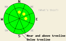
This morning the avalanche danger is LOW for all elevations and aspects. Some small, isolated pockets of MODERATE danger may develop near and above treeline on N-NE-E aspects steeper than 37 degrees by this afternoon. |
|
|
|
A small storm system moving southeast from the Pacific Northwest will bring increased westerly winds and some snow to the forecast area today. The winds started to increase overnight and have averaged between 55 and 60 mph since 2 am this morning. The snow showers that started this morning should only add another 1 inch of accumulation before tapering off this afternoon. As this storm moves east the winds should decrease and shift to the northwest by tomorrow.
Yesterday, layer bonding tests on Castle Peak indicated that the bond between the January 2nd rain crust and the snow above it has gained some strength. However, observations and snowpit data showed that facets continue to form near this crust. The clear and cold weather over the last two days has caused the snow surface temperatures to remain much colder than the temperatures 12 inches below the surface of the snow. This large difference in temperatures promotes the growth of weak faceted snow. As temperatures start to warm up the faceting near the rain crust should slow down. Tests on the deeper weak layers near the bottom of the snowpack indicate that these once faceted snow grains are starting to round and gain strength. Observations from Hidden Peak and Rubicon Peak from January 3rd show similar trends.
Today, the wind and new snow will only add minor loading to the snowpack. The current snowpack should be strong enough to handle this new load in most places. In areas that have more well developed facets near the January 2nd rain crust and receive more intense wind loading, some isolated pockets of instability may develop by this afternoon. These pockets would be most likely found on steep wind loaded N-NE-E aspects near and above treeline. Any avalanches that occur in these areas would likely only involve the snow above the January 2nd rain crust.
This morning the avalanche danger is LOW for all elevations and aspects. Some small, isolated pockets of MODERATE danger may develop near and above treeline on N-NE-E aspects steeper than 37 degrees by this afternoon.
| 0600 temperature: | 17 deg. F. |
| Max. temperature in the last 24 hours: | 24 deg. F. |
| Average wind direction during the last 24 hours: | West southwest |
| Average wind speed during the last 24 hours: | 10 mph until 6 pm last night then 35 mph |
| Maximum wind gust in the last 24 hours: | 71 mph |
| New snowfall in the last 24 hours: | 0-.1 inches |
| Total snow depth: | 64 inches |
For 7000-8000 ft: |
|||
| Monday: | Monday Night: | Tuesday: | |
| Weather: | Cloudy with a snow showers in the morning. Snow showers decreasing and becoming scattered this afternoon. | Mostly cloudy | Mostly cloudy |
| Temperatures: | 35-41 deg. F. | 19-26 deg. F. | 38-45 deg. F. |
| Wind direction: | West | West | Northwest |
| Wind speed: | 10-20 mph with gusts to 35 mph | 10 mph with gusts to 25 mph | 10 mph |
| Expected snowfall: | 0-1 in. | O in. | O in. |
For 8000-9000 ft: |
|||
| Monday: | Monday Night: | Tuesday: | |
| Weather: | Cloudy with a snow showers in the morning. Snow showers decreasing and becoming scattered this afternoon. | Mostly cloudy | Mostly cloudy |
| Temperatures: | 28-35 deg. F. | 20-27 deg. F. | 36-43 deg. F. |
| Wind direction: | West | Northwest | Northwest |
| Wind speed: | 30-45 with gusts to 70 mph | 30-40 mph with gusts to 70 mph | 20-35 mph with gusts to 60 mph |
| Expected snowfall: | 0-1 in. | O in. | O in. |


This website is owned and maintained by the non-profit arm of the Sierra Avalanche Center. Some of the content is updated by the USDA avalanche forecasters including the forecasts and some observational data. The USDA is not responsible for any advertising, fund-raising events/information, or sponsorship information, or other content not related to the forecasts and the data pertaining to the forecasts.

