In partnership with: 
|
January 16, 2009 at 7:43 am |
|
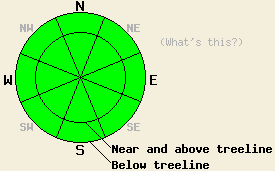
Avalanche danger is LOW for all elevations and aspects. Normal caution is advised. |
|
|
|
High pressure remains firmly in place over the forecast area. Easterly ridgetop winds increased about 10 mph overnight and will continue through today. Maximum daytime air temperatures will be a few degrees cooler than what was observed over the past few days. That said, air temperatures are still forecast to climb above freezing at all elevations. A weaker air temperature inversion is in place this morning with the coldest air once again below around 7,000'.
Observations from around the forecast area continue to indicate a stable snowpack. Southerly aspects hold thin to very thin snow cover while northerly aspects have a snowpack generally 3 to 6 feet deep in near and above treeline areas. Snow surface conditions are mixed and variable. Expect melt-freeze snow in sun exposed areas and either supportable or breakable crust in other areas. Surface snow that melted yesterday is expected to have refrozen overnight due to radiational cooling, despite above freezing air temperatures in many locations.
Melting of surface snow will occur in most sun exposed areas, especially around mid day in areas with direct southern exposure. Once areas transition from sun to shade, expect the snow surface to begin to refreeze. It is still January and the sun angle remains low, even though air temperatures are warm. Areas of wet snow or dry snow instability are not expected to occur today.
| 0600 temperature: | 32 deg. F. |
| Max. temperature in the last 24 hours: | 38 to 42 deg. F. |
| Average wind direction during the last 24 hours: | East |
| Average wind speed during the last 24 hours: | 32 mph |
| Maximum wind gust in the last 24 hours: | 58 mph |
| New snowfall in the last 24 hours: | O inches |
| Total snow depth: | 60 inches |
For 7000-8000 ft: |
|||
| Friday: | Friday Night: | Saturday: | |
| Weather: | Sunny skies. | Clear skies. | Sunny skies. |
| Temperatures: | 43 to 50 deg. F. | 22 to 32 deg. F. | 43 to 50 deg. F. |
| Wind direction: | SE to E | E | E |
| Wind speed: | 10 to 15 mph with gusts to 25 mph in the morning. | Around 10 mph. | Around 10 mph with gusts to 25 mph in the morning. |
| Expected snowfall: | O in. | O in. | O in. |
For 8000-9000 ft: |
|||
| Friday: | Friday Night: | Saturday: | |
| Weather: | Sunny skies. | Clear skies. | Sunny skies. |
| Temperatures: | 40 to 47 deg. F. | 27 to 33 deg. F. | 40 to 47 deg. F. |
| Wind direction: | SE to E | E | E |
| Wind speed: | 15 to 25 mph with gusts to 40 mph. | 15 to 25 mph with gusts to 40 mph. | 15 to 25 mph with gusts to 35 mph. |
| Expected snowfall: | O in. | O in. | O in. |


This website is owned and maintained by the non-profit arm of the Sierra Avalanche Center. Some of the content is updated by the USDA avalanche forecasters including the forecasts and some observational data. The USDA is not responsible for any advertising, fund-raising events/information, or sponsorship information, or other content not related to the forecasts and the data pertaining to the forecasts.

