In partnership with: 
|
January 19, 2009 at 7:54 am |
|
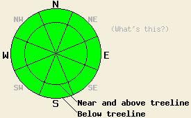
The avalanche danger remains LOW for all elevations and aspects. Use normal caution when traveling in the backcountry. |
|
|
|
As the high pressure ridge continues to move slowly eastward, the winds should shift more to the south over the next 24 hrs. Some scattered high clouds could start to develop later today and tomorrow. The temperatures should start to cool off over the forecast area as well. The forecast calls for slightly colder daytime highs in the upper 30's to low 40's above 8000' and mid 40's between 7000' and 8000'.
Observations from across the forecast area show a stable snowpack in most areas. Some near surface facets exist on and just below the crusts on northerly aspects. Currently, these weak, sugary snow grains pose little threat to backcountry travelers; however, they could become a failure layer during the next storm cycle. Breakable crusts, supportable crusts, and wind affected snow exist on the the surface in most areas. Melt-freeze conditions, a shallow snowpack, and areas of exposed ground exist on southerly aspects. Yesterday on these southerly aspects below 8500', 1 to 3 inches of surface snow softened for a few hours around midday. These areas quickly refroze as soon as they lost direct sun. Overnight the snowpack continued to refreeze due to radiational cooling and below freezing air temperatures.
The weak January sun, easterly winds, cooler daytime temperatures, and a strong overnight refreeze will keep wet snow instabilities from forming again today. The softening and melting that occurs today should only involve to the top few inches of snow on southerly, sun-exposed aspects. This snow will only be soft for a short time before quickly refreezing once it is shaded. All avalanche activity will remain unlikely today.
The avalanche danger remains LOW for all elevations and aspects. Use normal caution when traveling in the backcountry.
| 0600 temperature: | 32 deg. F. |
| Max. temperature in the last 24 hours: | 41 deg. F. |
| Average wind direction during the last 24 hours: | East to southeast |
| Average wind speed during the last 24 hours: | 24 mph |
| Maximum wind gust in the last 24 hours: | 35 mph |
| New snowfall in the last 24 hours: | O inches |
| Total snow depth: | 59 inches |
For 7000-8000 ft: |
|||
| Monday: | Monday Night: | Tuesday: | |
| Weather: | Sunny with a few high clouds late in the day | Mostly clear | Mostly sunny with a few scattered high clouds |
| Temperatures: | 41-48 deg. F. | 19-29 deg. F. | 41-48 deg. F. |
| Wind direction: | Southeast | Variable | South |
| Wind speed: | 10 mph | Light | 10 mph |
| Expected snowfall: | O in. | O in. | O in. |
For 8000-9000 ft: |
|||
| Monday: | Monday Night: | Tuesday: | |
| Weather: | Sunny with a few high clouds late in the day | Mostly clear | Mostly sunny with a few scattered high clouds |
| Temperatures: | 37-44 deg. F. | 23-29 deg. F. | 36-43 deg. F. |
| Wind direction: | Southeast | South | South |
| Wind speed: | 15-25 mph with gusts to 35 mph | 10-15 mph with gusts to 35 mph decreasing to 25 mph after midnight | 10-20 mph with gusts to 30 mph |
| Expected snowfall: | O in. | O in. | O in. |


This website is owned and maintained by the non-profit arm of the Sierra Avalanche Center. Some of the content is updated by the USDA avalanche forecasters including the forecasts and some observational data. The USDA is not responsible for any advertising, fund-raising events/information, or sponsorship information, or other content not related to the forecasts and the data pertaining to the forecasts.

