In partnership with: 
|
January 20, 2009 at 7:47 am |
|
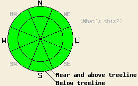
Avalanche danger remains LOW for all elevations and aspects. Normal caution is advised. |
|
|
|
A weather pattern change is in progress. Precipitation is expected to move into the forecast area beginning tomorrow. This morning, 6 am air temperatures across the northern half of the forecast area are a few degrees warmer than the past few mornings due to high clouds limiting radational cooling overnight. An air temperature inversion is in place once again with the coldest air below around 7,000'. Ridgetop winds have shifted from east to southwest overnight. Light winds this morning are expected to become moderate in speed as the day progresses.
Continued observations from around the forecast area all indicate a stable snowpack at this time. Basal snowpack layers are continuing to show gains in strength. The mid snowpack is quiet strong. The upper snowpack also shows good stability. Along the Sierra Crest, continued strength gains have been observed around the January 2nd rain crust. In the Mount Rose area, much more modest strength gains have been observed around crust layers within the top 1 foot of the snowpack.
At the snow surface, a variable mix of conditions are found by aspect, elevation, and location. Expect to find melt-freeze snow, supportable crust, breakable crust, and/or high density wind packed snow in most areas. A minority of areas have unconsolidated near surface faceted snow crystals, sometimes underneath a very thin breakable crust.
Today, any type of avalanche activity is unlikely. Melting of surface snow is expected in areas that receive direct sun. Surface melting will be increasingly limited to southerly aspects as elevation increases. Later today, areas of wet surface snow will refreeze slower in areas where cloud cover increases this afternoon and into the evening hours.
Avalanche danger remains LOW for all elevations and aspects. Normal caution is advised.
| 0600 temperature: | 36 deg. F. |
| Max. temperature in the last 24 hours: | 42 deg. F. |
| Average wind direction during the last 24 hours: | East shifting to southwest. |
| Average wind speed during the last 24 hours: | 16 mph |
| Maximum wind gust in the last 24 hours: | 29 mph |
| New snowfall in the last 24 hours: | O inches |
| Total snow depth: | 58 inches |
For 7000-8000 ft: |
|||
| Tuesday: | Tuesday Night: | Wednesday: | |
| Weather: | Partly cloudy skies. | Cloudy skies. | Cloudy skies with a slight chance of rain in the morning. Then a chance of rain and snow in the afternoon. |
| Temperatures: | 39 to 46 deg. F. | 27 to 33 deg. F. | 37 to 44 deg. F. |
| Wind direction: | SW | Variable, becoming S after midnight. | S |
| Wind speed: | Light winds. | Up to 10 mph. | Around 10 mph. |
| Expected snowfall: | O in. | O in. | 0 to 1 in. |
For 8000-9000 ft: |
|||
| Tuesday: | Tuesday Night: | Wednesday: | |
| Weather: | Partly cloudy skies. | Cloudy skies. | Cloudy skies with a slight chance of snow in the morning. Then a chance of snow in the afternoon. |
| Temperatures: | 38 to 44 deg. F. | 23 to 30 deg. F. | 34 to 41 deg. F. |
| Wind direction: | SW | S | S |
| Wind speed: | 10 to 20 mph with gusts to 30 mph. | 10 to 20 mph with gusts to 30 mph. | 15 to 25 mph with gusts to 45 mph. |
| Expected snowfall: | O in. | O in. | Trace to 2 in. |


This website is owned and maintained by the non-profit arm of the Sierra Avalanche Center. Some of the content is updated by the USDA avalanche forecasters including the forecasts and some observational data. The USDA is not responsible for any advertising, fund-raising events/information, or sponsorship information, or other content not related to the forecasts and the data pertaining to the forecasts.

