In partnership with: 
|
January 21, 2009 at 7:51 am |
|
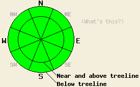
Avalanche danger is LOW for all elevations and aspects. Normal caution is advised. Avalanche danger is expected to increase overnight into Thursday. |
|
|
|
A warm subtropical weather system is approaching the forecast area. Light rain and snow showers are forecast to begin this afternoon. Snow level is expected at 7,000' to 8,000'. Precipitation intensity is forecast to increase tonight. This morning, ridgetop winds are light from the south. Winds are expected to increase to moderate in speed as the day progresses. An air temperature inversion is once again in place this morning with the coldest air below around 7,000'.
Continued observations from around the forecast area all indicate a stable snowpack at this time. At the snow surface, a variable mix of conditions are found by aspect, elevation, and location. Expect to find melt-freeze snow, supportable crust, breakable crust, and/or high density wind packed snow in most areas. A minority of areas have unconsolidated near surface faceted snow crystals, sometimes underneath a very thin breakable crust.
Today, the much anticipated rain and high density snowfall are not expected to create sufficient load to cause instability within the existing snowpack. This afternoon, only about 0.01 inch of rain or a trace of new snow is expected. Avalanche activity is unlikely during the day today. If precipitation intensity increases overnight as forecast, avalanche activity may become possible during the overnight hours.
Avalanche danger is LOW for all elevations and aspects. Normal caution is advised. Avalanche danger is expected to increase overnight into Thursday.
| 0600 temperature: | 38 deg. F. |
| Max. temperature in the last 24 hours: | 43 to 47 deg. F. |
| Average wind direction during the last 24 hours: | southwest to south |
| Average wind speed during the last 24 hours: | 10 mph |
| Maximum wind gust in the last 24 hours: | 30 mph |
| New snowfall in the last 24 hours: | O inches |
| Total snow depth: | 58 inches |
For 7000-8000 ft: |
|||
| Wednesday: | Wednesday Night: | Thursday: | |
| Weather: | Cloudy skies with scattered rain showers in the afternoon. | Cloudy skies with rain. | Cloudy skies with rain and snow. |
| Temperatures: | 40 to 47 deg. F. | 29 to 35 deg. F. | 34 to 40 deg. F. |
| Wind direction: | S | S | SW |
| Wind speed: | Around 10 mph. | Around 10 mph in the evening becoming light. | 10 to 15 mph with gusts to 25 mph. |
| Expected snowfall: | Rain 0.01 in. | Rain 0.25 to 0.5 in. | Above 7,500 ft, 2 to 4 in. |
For 8000-9000 ft: |
|||
| Wednesday: | Wednesday Night: | Thursday: | |
| Weather: | Cloudy skies with scattered snow showers in the afternoon. | Cloudy skies with snow. | Cloudy skies with snow showers. |
| Temperatures: | 40 to 46 deg. F. | 24 to 31 deg. F. | 33 to 39 deg. F. |
| Wind direction: | S | S | SW |
| Wind speed: | 15 to 20 mph with gusts to 30 mph. | 15 to 25 mph with gusts to 55 mph. | 10 to 20 mph with gusts to 30 mph. |
| Expected snowfall: | Trace in. | 2 to 5 in. | 2 to 5 in. |


This website is owned and maintained by the non-profit arm of the Sierra Avalanche Center. Some of the content is updated by the USDA avalanche forecasters including the forecasts and some observational data. The USDA is not responsible for any advertising, fund-raising events/information, or sponsorship information, or other content not related to the forecasts and the data pertaining to the forecasts.

