In partnership with: 
|
January 22, 2009 at 8:13 am |
|
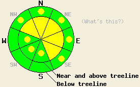
Above 8,000', avalanche danger is MODERATE on NW-N-NE-E-SE aspects 35 degrees and steeper. Below 8,000', avalanche danger in LOW with pockets of MODERATE danger on NW-N-NE-E-SE aspects 35 degrees and steeper. |
|
|
|
A subtropical weather system is currently affecting the forecast area. Rain and high elevation snow began yesterday evening. Snow levels have fluctuated between 7,000' and 8,000'. Remote sensors are reporting storm totals this morning of 2 to 4 inches of new snow above 8,000' and 0.25 to 0.4 inches of rain below 8,000'. Precipitation has been focused along the Sierra Crest with minimal precipitation reported from the Carson Range on the east side of Lake Tahoe. This trend is expected to continue until late this afternoon. Ridgetop winds are light to moderate in speed out of the southwest and are expected to continue today.
The prolonged period of high pressure has brought good stability to the existing snowpack. Good strength and stability were observed forecast area wide at the bottom and middle of the snowpack. Avalanche concerns for today are focused on new snow and the upper 1 foot of the existing snowpack.
Avalanche concern #1 - Wind loading
Up to an additional 8 inches of new snow is forecast to fall today above 8,000'. Near and above treeline areas where significant wind loading of new snow occurs will have the potential for human triggered avalanches today. Look for snowpack failure at the old/new snow interface and possibly on near surface faceted snow and crust layers within the top one foot of the snowpack.
Avalanche concern #2 - Rain on snow
During periods of high intensity precipitation today, snow levels may fall to near 7,000'. As snow level fluctuates back up towards 8,000', rain may fall on a few inches of new snow, creating surface snow instability. Additionally, below treeline areas on northerly aspects hold a layer of faceted snow at the surface up to 5 inches thick. This poorly bonded snow may act similar to new snow as rain falls on it. Human triggered avalanches are possible today in steep open areas where this snowpack structure exists.
Above 8,000', avalanche danger is MODERATE on NW-N-NE-E-SE aspects 35 degrees and steeper. Below 8,000', avalanche danger in LOW with pockets of MODERATE danger on NW-N-NE-E-SE aspects 35 degrees and steeper.
| 0600 temperature: | 29 deg. F. |
| Max. temperature in the last 24 hours: | 40 deg. F. |
| Average wind direction during the last 24 hours: | south shifting to southwest |
| Average wind speed during the last 24 hours: | 27 mph |
| Maximum wind gust in the last 24 hours: | 58 mph |
| New snowfall in the last 24 hours: | 2 to 4 inches |
| Total snow depth: | 57 inches |
For 7000-8000 ft: |
|||
| Thursday: | Thursday Night: | Friday: | |
| Weather: | Cloudy skies with rain, heavy at times. | Cloudy skies with periods of rain. | Cloudy skies with rain showers likely. |
| Temperatures: | 30 to 37 deg. F. | 23 to 30 deg. F. | 36 to 42 deg. F. |
| Wind direction: | SW | S | SE |
| Wind speed: | 10 to 15 mph with gusts to 25 mph. | Up to 10 mph. | Up to 10 mph. |
| Expected snowfall: | O in. | O in. | O in. |
For 8000-9000 ft: |
|||
| Thursday: | Thursday Night: | Friday: | |
| Weather: | Cloudy skies with rain and snow. | Cloudy skies with rain and snow. Snow level 8,000 ft. | Cloudy skies with rain and snow likely. |
| Temperatures: | 33 to 39 deg. F. | 22 to 29 deg. F. | 34 to 40 deg. F. |
| Wind direction: | SW | S | SW |
| Wind speed: | 10 to 20 mph with gusts to 40 mph. | 15 to 25 mph with gusts to 35 mph. | 10 to 15 mph with gusts to 30 mph. |
| Expected snowfall: | Up to 8 in. | Up to 6 in. | Up to 5 in. |


This website is owned and maintained by the non-profit arm of the Sierra Avalanche Center. Some of the content is updated by the USDA avalanche forecasters including the forecasts and some observational data. The USDA is not responsible for any advertising, fund-raising events/information, or sponsorship information, or other content not related to the forecasts and the data pertaining to the forecasts.

