In partnership with: 
|
January 23, 2009 at 8:00 am |
|
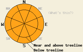
Between 7000' and 8500', the avalanche danger is CONSIDERABLE on all aspects 35 degrees and steeper that have received new snow in the last 24 hrs. Above 8500', avalanche danger is MODERATE with pockets of CONSIDERABLE danger on NW-N-NE-E-SE aspects 35 degrees and steeper. Below 7000' the avalanche danger is MODERATE with pockets of CONSIDERABLE on W-NW-N-NE-E aspects 35 degrees and steeper. |
|
|
|
After a small break in the weather late yesterday, a second, stronger storm system has started to affect the forecast area. This system brings more moisture and warmer temperatures. Freezing level has increased to between 8000' and 8500' feet this morning. The forecast calls for the freezing level to remain this high through today. Overnight the freezing level should start to drop. By midday tomorrow freezing level should be between 6000' and 6500'.
The Sierra Crest has received about .8-1.4 inches of precipitation in the last 24 hours as a mix of rain and snow. The Mt. Rose area picked up about 7 inches of new snow above 8000'. The forecast calls for another .5 to 1.5 inches of precipitation over the forecast area in the next 24 hours. Above 8500' this precipitation should fall as 11-20 inches of snow. Between 7500' and 8500' it should be a mix of rain and snow. Below 7500' it should be mostly rain. The winds should remain moderate out of the southwest through tomorrow.
Yesterday in the Carson Pass area several small test slopes failed in response to skier triggering. These failures occurred on a density change near the base of the new snow and resulted in small soft-slab avalanches with 6-10 inch crowns. Layer bonding tests in the Mt Rose area indicated poor bonding between the new snow and the old snow surfaces. Observers reported one natural avalanche that covered one lane of the Emerald Bay road. This slide resulted from rain on new snow due to the freezing level fluctuating between 6800' and 8000' during the day yesterday.
Today changing freezing levels (resulting in rain on new snow), new snow with wind, and more rain will create three avalanche concerns. The first concern will be avalanches resulting from rain on new snow between 7000' and 8500' today. As the freezing level rises rain falling on new snow will destabilize the new snow and should result in avalanche activity. Human triggering of this kind of instability will be probable and some natural avalanches could be possible due to this instability.
Newly formed wind slabs on NW-N-NE-E-SE aspects above 8500' will form the second avalanche concern today. These wind slabs sit on a mix of surface crusts and facets. Human triggering of these avalanches will be possible today. As these wind slabs grow in size, triggering of these wind slabs will become easier.
The third, more uncertain avalanche concern will result from the large amount of rain that continues to fall below 7500'. In the last 24 hours .8-1.4 inches of rain has fallen. Another .25-.75 inches of rain expected in the next 24 hours. This additional water will add weight and lubrication to the snowpack. It will also dissolve the bonds that currently hold the snowpack together. If it saturates the snowpack and dissolves enough of those bonds, wet slab avalanche activity could become possible.
Between 7000' and 8500', the avalanche danger is CONSIDERABLE on all aspects 35 degrees and steeper that have received new snow in the last 24 hrs. Above 8500', avalanche danger is MODERATE with pockets of CONSIDERABLE danger on NW-N-NE-E-SE aspects 35 degrees and steeper. Below 7000' the avalanche danger is MODERATE with pockets of CONSIDERABLE on W-NW-N-NE-E aspects 35 degrees and steeper.
| 0600 temperature: | 32-33 deg. F. |
| Max. temperature in the last 24 hours: | 34 deg. F. |
| Average wind direction during the last 24 hours: | Southwest |
| Average wind speed during the last 24 hours: | 29 mph |
| Maximum wind gust in the last 24 hours: | 57 mph |
| New snowfall in the last 24 hours: | Snow totals 3-5 in. with rain totals .6-1.1 inches |
| Total snow depth: | 61 inches |
For 7000-8000 ft: |
|||
| Friday: | Friday Night: | Saturday: | |
| Weather: | Rain | Rain mixed with snow. Freezing levels dropping to 7500 ft. | Snow showers likely. Freezing level dropping to 6000 ft-6500 ft by midday. |
| Temperatures: | 36-42 deg. F. | 25-34 deg. F. | 34-40 deg. F. |
| Wind direction: | Southwest | South | Southwest |
| Wind speed: | 10 mph | 10-15 mph with gusts to 30 mph | 10 mph |
| Expected snowfall: | rain totals .25-.5 in. | 4-8 in. | up to 5 in. |
For 8000-9000 ft: |
|||
| Friday: | Friday Night: | Saturday: | |
| Weather: | Rain and snow mixed. Freezing level 8000 ft-8500 ft. | Snow | Snow showers likely |
| Temperatures: | 34-40 deg. F. | 23-30 deg. F. | 32-38 deg. F. |
| Wind direction: | Southwest | Southwest | Southwest |
| Wind speed: | 10-15 mph with gusts to 30 mph | 15-20 mph with gusts to 40 mph | 15-20 mph with gusts to 30 mph |
| Expected snowfall: | above 8500 ft 3-6 in. | 8-14 in. | 2-6 in. |


This website is owned and maintained by the non-profit arm of the Sierra Avalanche Center. Some of the content is updated by the USDA avalanche forecasters including the forecasts and some observational data. The USDA is not responsible for any advertising, fund-raising events/information, or sponsorship information, or other content not related to the forecasts and the data pertaining to the forecasts.

