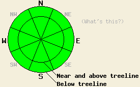
This Avalanche Advisory was published on February 3, 2009:

|
February 3, 2009 at 7:40 am |
|
Avalanche danger is LOW for all elevations and aspects. Normal caution is advised. |
|
|
|
Forecast Discussion:
Sunny skies and mild weather will continue today and tomorrow morning before a change in the weather pattern begins to affect the forecast area tomorrow afternoon. An air temperature inversion is in place this morning with most remote sensors above 7,000' reporting air temperatures in the upper 30s to low 40s. The exception to this seems to be in the Carson Pass area where the inversion level is a bit higher. Ridgetop winds shifted to the south yesterday afternoon and are light this morning.
General observations and snowpit data from around the forecast area continue to indicate a stable snowpack. Some faceting has been observed within the recent storm snow and around the January 22-23 rain crust. Stability tests are indicating failure of the rain crust layer under moderate to hard force. No evidence of fracture propagation potential has been observed and failure of this layer remains unlikely at this time. Large patches of surface hoar formation have been observed in wind protected open areas, generally at lower elevations. Existing surface hoar will only pose a problem if it manages to persist through Wednesday evening. For today, natural and human triggered avalanche activity remains unlikely.
Snow surface conditions are very dependent on aspect and wind exposure. Above treeline, expect high density wind affected snow surfaces on all aspects. In sun exposed areas, melt-freeze conditions exist. Very enjoyable unconsolidated snow surface conditions remain in wind sheltered areas on NW-N-NE aspects.
Weather Observations from along the Sierra Crest between 8200 ft and 8800 ft:
| 0600 temperature: | 40 deg. F. |
| Max. temperature in the last 24 hours: | 52 deg. F. |
| Average wind direction during the last 24 hours: | Northeast shifting to south. |
| Average wind speed during the last 24 hours: | Calm until 0300, then 10 mph |
| Maximum wind gust in the last 24 hours: | 16 mph |
| New snowfall in the last 24 hours: | O inches |
| Total snow depth: | 67 inches |
Two-Day Mountain Weather Forecast - Produced in partnership with the Reno NWS
For 7000-8000 ft: |
|||
| Tuesday: | Tuesday Night: | Wednesday: | |
| Weather: | Sunny skies. | Clear skies. | Sunny skies in the morning, becoming partly cloudy. |
| Temperatures: | 44 to 51 deg. F. | 27 to 33 deg. F. | 48 to 54 deg. F. |
| Wind direction: | S | S | S |
| Wind speed: | Around 10 mph. | Around 10 mph in the evening becoming light. | 10 to 15 mph with gusts to 25 mph in the morning. |
| Expected snowfall: | O in. | O in. | O in. |
For 8000-9000 ft: |
|||
| Tuesday: | Tuesday Night: | Wednesday: | |
| Weather: | Sunny skies. | Clear skies. | Sunny skies in the morning, becoming partly cloudy. |
| Temperatures: | 38 to 45 deg. F. | 26 to 33 deg. F. | 41 to 47 deg. F. |
| Wind direction: | S | S | S |
| Wind speed: | 10 to 15 mph with gusts to 25 mph. | 10 to 15 mph with gusts to 25 mph, increasing to 15 to 25 mph with gusts to 35 mph after midnight. | 20 to 30 mph with gusts to 40 mph. |
| Expected snowfall: | O in. | O in. | O in. |


