In partnership with: 
|
February 4, 2009 at 8:00 am |
|
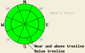
The avalanche danger is LOW for all elevations and aspects. Use normal caution when traveling in the backcountry. |
|
|
|
The strong high pressure ridge should cause warm, sunny weather to remain through today. This spring-like weather should start to change as a low pressure system moves toward the forecast area. This approaching low should bring more clouds and cooler temperatures tonight. Freezing level should drop to between 6000' and 6500' by tomorrow morning. The forecast calls for snow to begin falling Thursday with up to 4 inches of accumulation above 8000' during the day. This low pressure should begin a more active and wetter weather pattern.
Yesterday, observations from the Silver Peak and the Tamarack Peak (Mt. Rose backcountry) areas continue to show a mostly stable snowpack. Over the last few days observations and snowpit data from across the forecast area also show a strong, stable snowpack. The mild, sunny weather has created melt/freeze conditions on southerly aspects up to 9000'. Observers in the Mount Rose area reported some softening on these slopes due to daytime warming. Above 7000' on NW-N-NE-E aspects sheltered from the wind and sun, several inches of unconsolidated surface snow and near surface facets still remain. On the more wind and sun exposed slopes on these aspects wind crusts and melt/freeze conditions exist. The sun and warm temperatures also seem to have destroyed most of the large areas of surface hoar that had formed. There may still be some areas where this surface hoar could be buried and cause a problem during the upcoming storm. Please let us know what snow surface conditions you see today especially if you see any areas of surface hoar.
For now avalanche activity will remain unlikely; however, as winter returns to the forecast area tomorrow, expect the avalanche danger to increase.
The avalanche danger is LOW for all elevations and aspects. Use normal caution when traveling in the backcountry.
| 0600 temperature: | 37 deg. F. |
| Max. temperature in the last 24 hours: | 51 deg. F. |
| Average wind direction during the last 24 hours: | Variable between south-southeast and south-southwest |
| Average wind speed during the last 24 hours: | 12-14 mph |
| Maximum wind gust in the last 24 hours: | 32 mph |
| New snowfall in the last 24 hours: | O inches |
| Total snow depth: | 67 inches |
For 7000-8000 ft: |
|||
| Wednesday: | Wednesday Night: | Thursday: | |
| Weather: | Sunny in the morning with some clouds moving into the area this afternoon. | Mostly cloudy | Scattered snow showers in the morning becoming more widespread in the afternoon. |
| Temperatures: | 49-55 deg. F. | 21-28 deg. F. | 30-37 deg. F. |
| Wind direction: | South | South | South |
| Wind speed: | 10-15 mph with gusts to 25 mph in the morning | 10-15 mph with gusts to 30 mph | 10-15 mph with gusts to 25 mph |
| Expected snowfall: | O in. | O in. | 1-2 in. |
For 8000-9000 ft: |
|||
| Wednesday: | Wednesday Night: | Thursday: | |
| Weather: | Sunny in the morning with some clouds moving into the area this afternoon. | Mostly cloudy | Scattered snow showers in the morning becoming more widespread in the afternoon. |
| Temperatures: | 43-51 deg. F. | 21-29 deg. F. | 29-35 deg. F. |
| Wind direction: | South | South | South |
| Wind speed: | 10-15 mph with gusts to 40 mph | 10-20 mph with gusts to 45 mph | 15-20 mph with ridgetop gusts to 70 mph |
| Expected snowfall: | O in. | O in. | 2-4 in. |


This website is owned and maintained by the non-profit arm of the Sierra Avalanche Center. Some of the content is updated by the USDA avalanche forecasters including the forecasts and some observational data. The USDA is not responsible for any advertising, fund-raising events/information, or sponsorship information, or other content not related to the forecasts and the data pertaining to the forecasts.

