In partnership with: 
|
February 9, 2009 at 7:59 am |
|
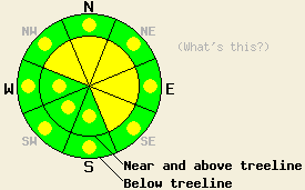
Near and above treeline, avalanche danger is MODERATE on NW-N-NE-E-SE aspects, 35 degrees and steeper. Below treeline, avalanche danger is LOW with pockets of MODERATE danger in open areas, 37 degrees and steeper. |
|
|
|
The storm system that began affecting the forecast area yesterday afternoon through this morning is expected to wind down late this morning. Snowfall accumulations from the last 18 hours are 12 to 17 inches along the Sierra Crest. Remote sensors report around 5 to 6 inches of new snow fell in the Mount Rose area. Ridgetop winds remain southwest this morning. Maximum wind speeds for this weather event peaked overnight and are forecast to shift to west and remain moderate in speed today. Air temperatures this morning are in the teens in nearly all areas and are only expected to warm a few degrees during the day today.
Yesterday, widespread reports of graupel at the onset of snowfall were received from the Bear Valley, Heavenly, Mt. Rose and Donner Summit areas. On Blood's Ridge (Bear Valley/Ebbetts Pass area), small surface hoar was observed on the old snow surface and ridgetop winds remained fairly light during the day. On Mt. Judah (Donner Summit area), southwest ridgetop winds became strong and were reported to move snow. Wind loading of to 5 inches deep was reported on NE aspects above treeline with minimal instability observed on 35 to 40 degree slopes.
Overnight and this morning, over a foot to a foot and a half of new snow fell along the Sierra Crest. Air temperatures above 8,000' were in the low 20s at the onset of precipitation and have steadily become colder during the storm event. This will have helped to continually place lower density snow at the top of the storm snow layer. Current snowpack instability is expected to limit to the base of the storm snow layer and within the storm snow layer. Strong SW winds are expected to have created significant wind loading on NW-N-NE-E-SE aspects in near and above treeline areas.
Today, a thin layer of graupel crystals at or near the base of the storm snow may act as a weak layer. Any areas of buried surface hoar, most likely to exist lower on peaks in larger wind protected open areas will also contribute to snowpack instability. The best opportunity of natural avalanche activity occurred during the overnight hours and is past. Evidence of it may be observed today, especially along the Sierra Crest. Human triggered avalanches that are large enough to bury a person remain possible and should be expected today in steep wind loaded areas near and above treeline. Significant instability will occur in any steep open areas below treeline where buried surface hoar exists at the bottom of the storm snow layer.
Near and above treeline, avalanche danger is MODERATE on NW-N-NE-E-SE aspects, 35 degrees and steeper. Below treeline, avalanche danger is LOW with pockets of MODERATE danger in open areas, 37 degrees and steeper.
| 0600 temperature: | 12 deg. F. |
| Max. temperature in the last 24 hours: | 23 deg. F. |
| Average wind direction during the last 24 hours: | Southwest |
| Average wind speed during the last 24 hours: | 45 mph |
| Maximum wind gust in the last 24 hours: | 68 mph |
| New snowfall in the last 24 hours: | 12 to 17 inches |
| Total snow depth: | 86 inches |
For 7000-8000 ft: |
|||
| Monday: | Monday Night: | Tuesday: | |
| Weather: | Numerous snow showers in the morning, then scattered snow showers in the afternoon. | Partly cloudy skies with isolated snow showers in the evening. | Mostly cloudy skies. |
| Temperatures: | 14 to 21 deg. F. | 7 to 15 deg. F. | 22 to 29 deg. F. |
| Wind direction: | W | NW | SW |
| Wind speed: | 15 to 20 mph with gusts to 35 mph. | 10 to 15 mph with gusts to 25 mph. Winds decreasing to around 10 mph after midnight. | Light in the morning, increasing to 10 to 15 mph with gusts to 30 mph in the afternoon. |
| Expected snowfall: | Up to 2 in. | Trace in. | O in. |
For 8000-9000 ft: |
|||
| Monday: | Monday Night: | Tuesday: | |
| Weather: | Numerous snow showers in the morning, then scattered snow showers in the afternoon. | Partly cloudy skies with isolated snow showers in the evening. | Mostly cloudy skies. |
| Temperatures: | 13 to 19 deg. F. | 7 to 13 deg. F. | 19 to 26 deg. F. |
| Wind direction: | W | NW | NW shifting to W |
| Wind speed: | 20 to 35 mph with gusts to 55 mph. | 15 to 25 mph with gusts to 35 mph. | Around 10 mph in the morning, increasing to 20 to 30 mph with gusts to 55 mph in the afternoon. |
| Expected snowfall: | Up to 2 in. | Trace in. | O in. |


This website is owned and maintained by the non-profit arm of the Sierra Avalanche Center. Some of the content is updated by the USDA avalanche forecasters including the forecasts and some observational data. The USDA is not responsible for any advertising, fund-raising events/information, or sponsorship information, or other content not related to the forecasts and the data pertaining to the forecasts.

