In partnership with: 
|
February 11, 2009 at 7:59 am |
|
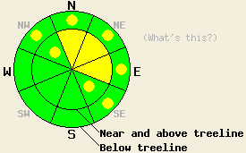
Near and above treeline the avalanche danger is MODERATE on N-NE-E aspects on slopes steeper than 35 degrees. Pockets of MODERATE danger may exist on cross-loaded NW and SE aspects as well. Below treeline the avalanche danger is LOW with pockets of MODERATE in open areas, 37 degrees and steeper on NW-N-NE-E-SE aspects. |
|
|
|
The initial cold front associated with the low pressure system off the west coast pushed a band of precipitation through the forecast area last night adding another 4-7 inches of new snow to the snowpack. Southwest winds increased late yesterday and remained in the mid to high 30's overnight. A small break in the weather should occur during the day today with winds and snowfall decreasing. As this low starts to move eastward another more intense wave of snow should reach the forecast area starting this evening with 6-12 inches of accumulation expected overnight. A small, short-lived high pressure ridge follows this storm during the day tomorrow before a stronger, wetter low pressure system reaches the forecast area Thursday night.
The strong west southwest winds continued to reload the leeward starting zones during the day yesterday. By mid-afternoon small wind slabs sensitive to human triggering had formed on N-NE-E aspects. In the Mt. Judah area these slabs did not grow large enough to pose much of a threat to backcountry travelers. Some small avalanches with 3-5 inch crowns that ran 5-15 feet downhill occurred on small NE and E facing test slopes steeper than 37 degrees in response to a skier's weight. Observers also reported growing cornices and small new wind slabs on Donner Ridge, in the Carson Pass area, and in the Mt. Rose area. Layer bonding tests in in the Mt. Judah area, the Mt. Rose area, and on Donner Ridge all showed poor bonding between these new wind slabs and the snow beneath them. These tests also showed the bonds within the 2/8-2/9 storm snow and between this snow and the older crusts / scoured surfaces have continued to gain strength.
The wind slabs that started to form yesterday will comprise the chief avalanche concern today. These slabs should have grown larger and become more widespread overnight due to new snow and continued southwest winds. Some avalanches involving these wind slabs may have occurred naturally last night. The decrease in the winds and snowfall expected today should limit natural activity during the day. However, human-triggered avalanche activity resulting from failure of these newly formed wind slabs will continue to be possible throughout today. Any avalanches that do occur today could have crowns of more than 2 feet in on the most heavily wind loaded slopes. The largest of these new wind slabs should exist on the N-NE-E aspects near and above treeline. Some smaller versions of the wind slabs could have formed on the SE and NW aspects near and above treeline due to cross loading and on open wind loaded slopes below treeline. Use clues like blowing snow, drifts, ripples, cornices, and other signs of wind loading to help determine where these wind slabs exist and use extra caution around them.
Near and above treeline the avalanche danger is MODERATE on N-NE-E aspects on slopes steeper than 35 degrees. Pockets of MODERATE danger may exist on cross-loaded NW and SE aspects as well. Below treeline the avalanche danger is LOW with pockets of MODERATE in open areas, 37 degrees and steeper on NW-N-NE-E-SE aspects.
| 0600 temperature: | 17 deg. F. |
| Max. temperature in the last 24 hours: | 18-22 deg. F. |
| Average wind direction during the last 24 hours: | Southwest |
| Average wind speed during the last 24 hours: | 30-35 mph |
| Maximum wind gust in the last 24 hours: | 68 mph |
| New snowfall in the last 24 hours: | 4-7 inches |
| Total snow depth: | 84 inches |
For 7000-8000 ft: |
|||
| Wednesday: | Wednesday Night: | Thursday: | |
| Weather: | Light snow this morning becoming heavier by this evening | Snow | Partly cloudy in the morning becoming mostly cloudy with a chance of snow by the afternoon |
| Temperatures: | 21-26 deg. F. | 13-17 deg. F. | 22-27 deg. F. |
| Wind direction: | Southwest | Southwest shifting to the west | Southwest |
| Wind speed: | 10-20 mph with gusts between 30 and 35 mph in the morning decreasing to 10-15 mph in the afternoon | 5-15 mph | 10 mph |
| Expected snowfall: | up to 4 in. | 6-12 in. | trace in. |
For 8000-9000 ft: |
|||
| Wednesday: | Wednesday Night: | Thursday: | |
| Weather: | Light snow this morning becoming heavier by this evening | Snow | Partly cloudy in the morning becoming mostly cloudy with a chance of snow by the afternoon |
| Temperatures: | 14-21 deg. F. | 9-15 deg. F. | 15-22 deg. F. |
| Wind direction: | Southwest | Southwest shifting to the west after midnight | North shifting to the west |
| Wind speed: | 30-40 mph with gusts to 65 mph in the morning decreasing to 20-30 mph with gusts to 50 mph this afternoon | 20-30 mph with gusts to 40 mph decreasing to 10-20 mph after midnight | 10-15 mph in the morning with gusts to 25 mph in the afternoon |
| Expected snowfall: | up to 4 in. | 6-12 in. | trace in. |


This website is owned and maintained by the non-profit arm of the Sierra Avalanche Center. Some of the content is updated by the USDA avalanche forecasters including the forecasts and some observational data. The USDA is not responsible for any advertising, fund-raising events/information, or sponsorship information, or other content not related to the forecasts and the data pertaining to the forecasts.

