In partnership with: 
|
February 12, 2009 at 8:00 am |
|
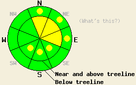
This morning the avalanche danger remains MODERATE on N-NE-E aspects on slopes steeper than 37 degrees near and above treeline. By this afternoon pockets of MODERATE danger may develop on SE-S-SW aspects steeper than 37 degrees as well. Below treeline the avalanche danger is LOW with pockets of MODERATE in open wind loaded areas, 37 degrees and steeper on N-NE-E aspects. |
|
|
|
Since 6 am yesterday the forecast area has received another 6-9 inches of snow above 7000' along the Sierra Crest and 2-3 more inches in the Carson Range east of Lake Tahoe. Most of this snow fell between 5 pm yesterday and midnight last night. Skies started to clear after midnight as the low pressure moved out of the forecast area. Remote sensors indicate that the southwest winds associated with this storm also started to decrease after midnight and even started to shift to the west and northwest over the Mt. Rose area. This clearing trend and the decreasing winds shifting to the northwest should continue through this afternoon as a small high pressure ridge affects the forecast area. By tonight more clouds, more snow, and strong southwest winds should return as another low pressure moves over the central Sierra. By the end of the day tomorrow the forecast calls for another 8-12 inches of snow above 7000'.
Yesterday layer bonding tests on Hidden Peak showed easy failures at the interface between Tuesday night's new snow and Sunday night's snow. However, observations also showed very little slab formation in Tuesday night's new snow. Near the top of the peak the southwest winds had created some small wind drifts where this snow did have enough slab-like properties to crack under a skier's weight. The bonding tests also showed that the bonds within Sunday night's snow and between this snow and the older crusts / scoured surfaces have continued to gain strength. No natural avalanche activity was observed on the slopes in the Desolation Wilderness that are visible from the top of Hidden Peak nor did we receive any reports of backcountry avalanche activity. If you have any snowpack, weather, or avalanche observations you would like to share with us please click here. Observations from the Mt. Rose area, Carson Pass area, and the Donner Summit area over the last few days also show a strengthening trend in the upper layers of the snowpack. Along exposed ridges in these areas some large, tender cornices have formed and some wind slabs exist on leeward slopes near and above treeline.
Today the primary avalanche concern will continue to be the wind slabs formed by the southwest winds and the 10-15 inches new snow over the last 36 hours. Even though the winds and snow have started to decrease these slabs will still exist. The largest of these slabs should exist on the exposed N-NE-E aspects near and above treeline. The weight of a skier, boarder, or snow mobiler could still cause some of these wind slabs to fail today. If avalanches do occur due to the failure of these wind slabs, they will likely start in last night's new snow and could step down into Tuesday night's snow or even into Sunday night's snow resulting in crowns of 1-3 feet. As the northwest winds increase today, they should transport some snow away from these slabs making them slightly smaller. However, this transport will form new wind slabs on the E-SE-S-SW aspects. Most of these slabs should remain small due to the low wind speeds expected today. Use clues like blowing snow, drifts, ripples, cornices, and other signs of wind loading to help determine where wind slabs exist and use extra caution around them. In non wind affected areas the new snow should be less prone to forming slabs resulting in less instability in these areas.
This morning the avalanche danger remains MODERATE on N-NE-E aspects on slopes steeper than 37 degrees near and above treeline. By this afternoon pockets of MODERATE danger may develop on SE-S-SW aspects steeper than 37 degrees as well. Below treeline the avalanche danger is LOW with pockets of MODERATE in open wind loaded areas, 37 degrees and steeper on N-NE-E aspects.
| 0600 temperature: | 9 deg. F. |
| Max. temperature in the last 24 hours: | 18 deg. F. |
| Average wind direction during the last 24 hours: | Southwest starting to shift to the west and northwest early this morning |
| Average wind speed during the last 24 hours: | 25-30 mph |
| Maximum wind gust in the last 24 hours: | 58 mph |
| New snowfall in the last 24 hours: | 6-9 inches |
| Total snow depth: | 89 inches |
For 7000-8000 ft: |
|||
| Thursday: | Thursday Night: | Friday: | |
| Weather: | Partly cloudy with some isolated snow showers in the morning | Cloudy with a chance of snow | Snow |
| Temperatures: | 21-26 deg. F. | 12-17 deg. F. | 16-22 deg. F. |
| Wind direction: | Northwest | Southwest | Southwest |
| Wind speed: | 10 mph | 10-15 mph with gusts to 25 mph increasing to 15-25 mph with gusts to 45 mph after midnight | 15-30 mph with gusts to 50 mph decreasing to 10-20 mph with gusts to 35 mph |
| Expected snowfall: | O in. | up to 2 in. | 6-10 in. |
For 8000-9000 ft: |
|||
| Thursday: | Thursday Night: | Friday: | |
| Weather: | Partly cloudy with some isolated snow showers in the morning | Cloudy with snow showers likely after midnight | Snow |
| Temperatures: | 14-22 deg. F. | 10-15 deg. F. | 14-19 deg. F. |
| Wind direction: | Northwest | Southwest | Southwest shifting to the west |
| Wind speed: | 10-20 mph | 20-30 mph with gusts to 40 mph increasing to 30-35 mph with gusts to 60 mph after midnight | 30-45 mph with gusts to 90 mph decreasing to 20-25 mph with gusts to 50 mph in the afternoon |
| Expected snowfall: | O in. | up to 3 in. | 6-10 in. |


This website is owned and maintained by the non-profit arm of the Sierra Avalanche Center. Some of the content is updated by the USDA avalanche forecasters including the forecasts and some observational data. The USDA is not responsible for any advertising, fund-raising events/information, or sponsorship information, or other content not related to the forecasts and the data pertaining to the forecasts.

