In partnership with: 
|
February 14, 2009 at 8:00 am |
|
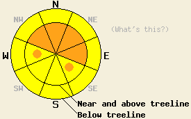
Near and above treeline, avalanche danger is CONSIDERABLE on NW-N-NE-E aspects, 35 degrees and steeper. Below treeline, avalanche danger is MODERATE in open areas, 35 degrees and steeper. |
|
|
|
The latest in the steady progression of storm systems to affect the forecast area continues this morning. Snow showers and sun breaks are expected during the day today. Above 7,000', an additional 10 to 14 inches of new snow fell across the forecast area last night. This brings 24 hour snow totals at the upper elevations to 16 to 22 inches. Air temperatures in the single digits and teens this morning are expected to warm into the mid teens and low 20s today. Ridgetop winds out of the southwest became strong during the early morning hours, but are expected to decrease to moderate in speed as the day progresses.
Yesterday, observations made on Hidden Peak (West Shore Tahoe area) indicated significant instability within the new snow in areas above 8,300'. Widespread small human triggered avalanches were observed near and above treeline in wind loaded areas on N-NE aspects between 35 and 38 degrees in slope angle. A few small human triggered avalanches were intentionally caused in steep open areas below treeline. None of the observed avalanches were large enough to bury a person. Typical crown height measured 6 to 8 inches and up to 25 to 30 feet wide. Numerous shooting cracks were reported in the area both above and below treeline. On Silver Peak (North of Squaw Peak), no shooting cracks were observed, but stability tests indicated similar weakness within the new snow as that reported from Hidden Peak. Close examination of the snowpack indicated that the layer of faceted snow crystals that exists at the interface between the January 22-23 rain crust and the February 6 storm snow is becoming increasingly worrisome. This layer has been observed below 8,700' in the Mt. Judah (Donner Summit area ) Silver Peak area, Mt. Tallac (Desolation Wilderness area), and outside the boundaries of the Bear Valley ski area. Over the past few days, stability tests have shown a general weakening of the layer interface with stability test scores dropping from hard to moderate. Tests also have shown increasing potential for fracture propagation on this layer. Failure of this snowpack layer would cause larger avalanches involving all of the new snow received during the month of February, with crowns likely 3 to 6 feet deep.
Today, an additional 10 to 14 inches of new snow on top of an already unstable snowpack will allow the possibility of natural and human triggered slab avalanches to continue. The greatest areas of instability and larger slabs are expected near and above treeline on wind loaded NW-N-NE-E aspects, 35 degrees and steeper. Below treeline, pockets of small slabs should be expected in steep open wind affected areas, especially above 8,000'. In steep open areas not affected by wind, human triggered sluff activity should be expected. A good window for natural avalanche activity occurred last night. Fresh crowns and debris may be observed in the backcountry today.
Near and above treeline, avalanche danger is CONSIDERABLE on NW-N-NE-E aspects, 35 degrees and steeper. Below treeline, avalanche danger is MODERATE in open areas, 35 degrees and steeper.
| 0600 temperature: | 11 deg. F. |
| Max. temperature in the last 24 hours: | 13 deg. F. |
| Average wind direction during the last 24 hours: | Southwest |
| Average wind speed during the last 24 hours: | 48 mph |
| Maximum wind gust in the last 24 hours: | 91 mph |
| New snowfall in the last 24 hours: | 16 to 20 inches |
| Total snow depth: | 100 inches |
For 7000-8000 ft: |
|||
| Saturday: | Saturday Night: | Sunday: | |
| Weather: | Snow showers and sun breaks. | Scattered snow showers in the evening, then numerous snow showers after midnight. | Cloudy skies with snow. |
| Temperatures: | 22 to 29 deg. F. | 12 to 19 deg. F. | 22 to 29 deg. F. |
| Wind direction: | SW | S | S |
| Wind speed: | 10 to 20 mph with gusts to 35 mph | 15 to 25 mph with gusts to 40 mph | 20 to 35 mph with gusts to 55 mph |
| Expected snowfall: | Up to 3 in. | Up to 2 in. | Up to 8 in. |
For 8000-9000 ft: |
|||
| Saturday: | Saturday Night: | Sunday: | |
| Weather: | Snow showers and sun breaks. | Scattered snow showers in the evening, then numerous snow showers after midnight. | Cloudy skies with snow. |
| Temperatures: | 12 to 22 deg. F. | 6 to 13 deg. F. | 12 to 22 deg. F. |
| Wind direction: | SW | S | SW |
| Wind speed: | 20 to 30 mph with gusts to 50 mph | 25 to 35 mph with gusts to 60 mph | 25 to 35 mph with gusts to 60 mph, increasing to 30 to 50 mph with gusts to 70 mph in the afternoon |
| Expected snowfall: | Up to 3 in. | Up to 2 in. | Up to 8 in. |


This website is owned and maintained by the non-profit arm of the Sierra Avalanche Center. Some of the content is updated by the USDA avalanche forecasters including the forecasts and some observational data. The USDA is not responsible for any advertising, fund-raising events/information, or sponsorship information, or other content not related to the forecasts and the data pertaining to the forecasts.

