In partnership with: 
|
February 16, 2009 at 8:00 am |
|
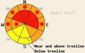
Large natural and human-triggered avalanches are likely. Near and above treeline the avalanche danger will increase to HIGH on NW-N-NE-E aspects steeper than 35 degrees by this afternoon. Pockets of HIGH danger should also develop on slopes steeper than 35 degrees on cross loaded W aspects at all evelations and on the NW-N-NE-E aspects below treeline. Avalanche activity will be less likely on the windward SE-S-SW aspects. Backcountry travel in or around avalanche terrain is not recommended. |
|
|
|
Another 12-14 inches of snow fell along the Sierra Crest and another 4-6 inches on the east side of the lake during the day yesterday. This brings total snow accumulation since Feb. 8th to 74-76 inches along the Sierra Crest and about 30-35 inches in the Mt Rose area. As the low pressure system off the coast of CA moves eastward over the next 36 hours, it should continue to push snow into the forecast area. Another 6-16 inches of snow should fall above 7000' along the crest today. The strong southwest winds shifted to the south overnight and should remain strong through today. By tomorrow they should shift back to the west and decrease.
Yesterday observers reported a skier-triggered avalanche on Becker Peak (near Echo Summit) on a 35 degree NE facing slope at 8000'. A natural cornice failure also triggered an avalanche on a NE aspect on Stevens Peak (near Carson Pass) at about 8000'. Shooting cracks and small test slope failures occurred on wind-loaded northerly aspects on Incline Lake Peak in the Mount Rose area and on Donner Summit. Layer bonding tests in these areas, the Bear Valley backcountry, and on the Alpine Meadows storm board this morning revealed poor bonding that failed with minimal force within the storm snow. Observations from across the forecast area over the last few days indicate that the recent storm snow and the strong winds have formed reactive wind slabs and cornices on open wind loaded terrain.
Today's primary avalanche concern will be these wind slabs. Wind slabs will continue to grow as more snow falls and the winds remain strong today. They should be largest and most widespread near and above treeline on wind loaded NW-N-NE-E aspects. Reactive wind slabs could also grow below treeline on open wind loaded slopes. Today, they could fail naturally due to the new snow and wind loading; they could fail due to natural cornice collapses; and they could easily fail due to human triggers. These slabs could be large and could step down to the older weak layers below February's snow.
These older weak layers are the second avalanche concern today. Snowpits along the Sierra Crest and in the Mount Rose area show that a small layer of weak facets has formed above the crusts that formed in late January. These facets have been growing weaker over the last few days and a skier triggered an avalanche down to this layer on Saturday. As more snow loads these weakening layers, large avalanches that occur due to failure at this layer should become easier to trigger. Today loading by new snow, wind, or people could be enough to release some of these deep slabs. Avalanches that occur due to failure at this layer could have crowns of more than 6 feet and could propagate across large areas. This weak layer exists both above and below treeline. It is weakest on the coldest aspects. Therefore, these avalanches will be most likely on all steep N-NE-E aspects where the most new snow has fallen. Avalanches due to this weakness will be less likely in the Carson Range east of Lake Tahoe due to the smaller amounts of snow that those mountains have received over the last 7 days.
Large natural and human-triggered avalanches are likely. Near and above treeline the avalanche danger will increase to HIGH on NW-N-NE-E aspects steeper than 35 degrees by this afternoon. Pockets of HIGH danger should also develop on slopes steeper than 35 degrees on cross loaded W aspects at all evelations and on the NW-N-NE-E aspects below treeline. Avalanche activity will be less likely on the windward SE-S-SW aspects. Backcountry travel in or around avalanche terrain is not recommended.
| 0600 temperature: | 20 deg. F. |
| Max. temperature in the last 24 hours: | 24 deg. F. |
| Average wind direction during the last 24 hours: | Southwest to south |
| Average wind speed during the last 24 hours: | 43 mph |
| Maximum wind gust in the last 24 hours: | 102 mph |
| New snowfall in the last 24 hours: | 12 inches |
| Total snow depth: | 88 inches |
For 7000-8000 ft: |
|||
| Monday: | Monday Night: | Tuesday: | |
| Weather: | Snow | Snow showers | Snow showers |
| Temperatures: | 16-26 deg. F. | 8-15 deg. F. | 16-26 deg. F. |
| Wind direction: | South shifting to southwest | West | West |
| Wind speed: | 15-25 mph with gusts to 40 mph | 20-30 mph with gusts to 45 mph | 15-20 mph with gusts to 35 mph |
| Expected snowfall: | 6-12 in. | 6-12 in. | 6-12 in. |
For 8000-9000 ft: |
|||
| Monday: | Monday Night: | Tuesday: | |
| Weather: | Snow | Snow showers | Snow showers |
| Temperatures: | 15-22 deg. F. | 7-15 deg. F. | 17-24 deg. F. |
| Wind direction: | South shifting to southwest | West | West |
| Wind speed: | 35-55 mph with gusts between 80-100 mph | 25-45 mph with gusts to 75 mph | 20-30 mph with gusts to 55 mph |
| Expected snowfall: | 8-16 in. | 8-16 in. | 6-12 in. |


This website is owned and maintained by the non-profit arm of the Sierra Avalanche Center. Some of the content is updated by the USDA avalanche forecasters including the forecasts and some observational data. The USDA is not responsible for any advertising, fund-raising events/information, or sponsorship information, or other content not related to the forecasts and the data pertaining to the forecasts.

