In partnership with: 
|
February 18, 2009 at 8:00 am |
|
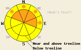
Near and above treeline the avalanche danger is CONSIDERABLE on NW-N-NE-E aspects steeper than 37 degrees. Pockets of CONSIDERABLE danger should also exist on slopes steeper than 37 degrees on the NW-N-NE-E aspects below treeline. Avalanche activity will be less likely on the windward SE-S-SW aspects. |
|
|
|
Only 3-5 inches of snow fell during the day yesterday across the forecast area. Remote sensors report another 2-5 inches overnight bringing the 24 hr snow totals to 5-10 inches. Areas along the western edge of the Sierra Crest received the most new snow while the areas farther to the east got less.The storm system should move east of the forecast area and snow showers should end early this morning. Some clouds should linger over the forecast area while a high pressure ridge builds over CA. This high pressure should bring clearing skies, warmer temperatures, and lighter winds to the area over the next few days.
Yesterday layer bonding tests from Deep Creek (north of Squaw), Jake's Peak (West shore area), and Echo Summit failed easily at the within the newest snow and at interface between the 2/16-2/17 snow and the storm snow below it. Weaknesses also still exist in the older storm snow. All of these storm snow weaknesses seem to be gaining some strength as the snow consolidates. Shooting cracks that propagated 20-30 ft occurred on wind loaded north aspects near the summit of Jake's and on N-NE aspects between 7200-8200 ft in the Deep Creek area. The snow that has accumulated since Feb. 8th sits on top of a thin layer of weak, faceted snow. Layer bonding tests indicate that these facets are barely able to support the weight of the snowpack above them in many areas. These tests also show that once this weak layer breaks, that fracture should propagate. Some large avalanches have occurred due to failure of this layer with minimal triggers.
The wind slabs that formed over the last week will continue to be the primary avalanche concern today. They should be most widespread near and above treeline on wind-loaded NW-N-NE-E aspects. Some pockets of fragile wind slabs could also still exist below treeline on open, wind-loaded slopes. While natural failure of these wind slabs should be less likely today, these slabs could still be very sensitive to human triggering or cornice collapses. These slabs could be large and could step down to the older weak layers below February's snow.
The second avalanche concern today will be failure of the weak facets at the base of the storm snow since Feb. 8th. People could still trigger large, deep slabs on this layer especially around likely trigger points. Avalanches that occur due to failure at this layer could have crowns of more than 8 feet and could propagate across large areas. This weak layer exists both above and below treeline. These avalanches will be most likely on all steep N-NE-E aspects.
Avalanche activity should be less likely in the Carson Range east of Lake Tahoe due to the smaller amounts of snow received in those mountains.
Near and above treeline the avalanche danger is CONSIDERABLE on NW-N-NE-E aspects steeper than 37 degrees. Pockets of CONSIDERABLE danger should also exist on slopes steeper than 37 degrees on the NW-N-NE-E aspects below treeline. Avalanche activity will be less likely on the windward SE-S-SW aspects.
| 0600 temperature: | 16 deg. F. |
| Max. temperature in the last 24 hours: | 21 deg. F. |
| Average wind direction during the last 24 hours: | Southwest |
| Average wind speed during the last 24 hours: | 35 mph |
| Maximum wind gust in the last 24 hours: | 72 mph |
| New snowfall in the last 24 hours: | 5-10 inches |
| Total snow depth: | 117 inches |
For 7000-8000 ft: |
|||
| Wednesday: | Wednesday Night: | Thursday: | |
| Weather: | Partly cloudy | Partly cloudy | Sunny |
| Temperatures: | 27-34 deg. F. | 15-21 deg. F. | 30-40 deg. F. |
| Wind direction: | South | South | Variable |
| Wind speed: | 10 mph | 10 mph | Light |
| Expected snowfall: | trace in. | O in. | O in. |
For 8000-9000 ft: |
|||
| Wednesday: | Wednesday Night: | Thursday: | |
| Weather: | Partly cloudy | Partly cloudy | Sunny |
| Temperatures: | 17-27 deg. F. | 10-20 deg. F. | 23-33 deg. F. |
| Wind direction: | South | South | Southwest |
| Wind speed: | 10-15 mph with gusts to 25 mph this afternoon | 10-15 mph with gusts to 25 mph | 10-15 mph |
| Expected snowfall: | trace in. | O in. | O in. |


This website is owned and maintained by the non-profit arm of the Sierra Avalanche Center. Some of the content is updated by the USDA avalanche forecasters including the forecasts and some observational data. The USDA is not responsible for any advertising, fund-raising events/information, or sponsorship information, or other content not related to the forecasts and the data pertaining to the forecasts.

