In partnership with: 
|
February 23, 2009 at 8:00 am |
|
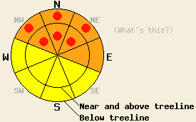
On slopes steeper than 35 degrees, the avalanche danger is CONSIDERABLE on NW-N-NE-E aspects at all elevations. Pockets of HIGH danger exist on the NW-N-NE aspects below 8700'. On the SE-S-SW-W aspects the avalanche danger is MODERATE at all elevations. The avalanche danger will be higher on any slopes that receive rain today. |
|
|
|
One more wave of precipitation associated with the low pressure off the coast should impact the forecast area this morning with freezing levels hovering between 6200' and 7000'. The forecast area should receive another 2-6 inches of wet heavy snow before the showers taper off this afternoon. The southwest winds should start to decrease overnight. By tomorrow skies should be partly cloudy, and the winds should be light or moderate out of the southwest.
Yesterday morning snow levels across the forecast area varied from between 7000' near Donner Pass to almost 8500' on the southeast side of Lake Tahoe. By yesterday afternoon snow levels had dropped between 6500' and 7000' through most of the forecast area. Areas along the Sierra Crest received between 2 and 3 inches of water over the last 24 hours. This precipitation amounted to 12-15 inches of dense snow in areas above the freezing level and a mix of snow and rain below. The Mt. Rose area picked up about 11 inches of the heavy, new snow. This new snow and the strong southwest winds formed dense wind slabs and heavy cornices on open, leeward slopes above and below treeline. Observations in the Mt. Judah area showed that these wind slabs had trouble bonding to the snow below them. By mid afternoon ski cuts released several, 8-12-inch-crown avalanches on wind-loaded, N-NE-facing, 35-37-degree test-slopes between 7400' and 8200'. One avalanche with an 8-16 inch crown occurred due to a natural cornice failure on a 37 degree NE facing slope at 8200 ft. Layer bonding tests on the facet / rain crust layers indicated that those layers seem to have strengthened some in the Mt. Judah area.
The new, heavy wind slabs will be the primary avalanche concern today. More new snow and strong southwest winds caused these wind slabs to grow overnight. Failure of these slabs could result in avalanches large enough to bury a person. These wind slabs will be most prevalent on open, wind-loaded N-NE-E aspects. They will be largest near and above treeline where most of the precipitation fell as snow. Skiers, snowboarders, snow-mobilers, and cornice failures could all trigger avalanches involving these wind slabs. It is possible that some of these wind slabs could still fail naturally; however, the best window for natural activity should have been yesterday afternoon and last night.
Today's second avalanche concern will be the persistent layer of weak facets sitting between January's crusts and February's snow. In areas where this layer exists, the snowpack may not be able to handle the new loading that has occurred over the last 24 hours. Some slopes where this layer exists may have already failed naturally yesterday. If they did not fail yesterday, natural and human-triggered avalanche activity due to failure at this layer will remain likely on NW-N-NE aspects below 8700' where these facets exist today. Avalanches involving this layer would be deep and destructive.
The third avalanche concern today will be rain on new snow. If the freezing level moves up again and rain falls on the new snow from last night, it will dissolve the bonds holding this snow in place and natural and human-triggerable avalanche activity could result. If the snow level stays low today, this concern will not be an issue.
On slopes steeper than 35 degrees, the avalanche danger is CONSIDERABLE on NW-N-NE-E aspects at all elevations. Pockets of HIGH danger exist on the NW-N-NE aspects below 8700'. On the SE-S-SW-W aspects the avalanche danger is MODERATE at all elevations. The avalanche danger will be higher on any slopes that receive rain today.
| 0600 temperature: | 28-30 deg. F. |
| Max. temperature in the last 24 hours: | 29-31 deg. F. |
| Average wind direction during the last 24 hours: | Southwest |
| Average wind speed during the last 24 hours: | 44 mph |
| Maximum wind gust in the last 24 hours: | 83 mph |
| New snowfall in the last 24 hours: | 12 inches |
| Total snow depth: | 122 inches |
For 7000-8000 ft: |
|||
| Monday: | Monday Night: | Tuesday: | |
| Weather: | Snow this morning tapering off to scattered showers this afternoon - snow level between 6000 ft. and 7000 ft. | Partly cloudy with a chance of snow | Partly cloudy with a slight chance of snow |
| Temperatures: | 33-40 deg. F. | 25-30 deg. F. | 35-42 deg. F. |
| Wind direction: | South | Southwest | Southwest |
| Wind speed: | 10-20 mph with gusts to 30 mph increasing to 15-25 mph with gusts to 40 mph this afternoon | 15-25 mph with gusts to 35 decreasing to 10 -15 mph after midnight | 10-15 mph |
| Expected snowfall: | 2-6 in. | trace in. | O in. |
For 8000-9000 ft: |
|||
| Monday: | Monday Night: | Tuesday: | |
| Weather: | Snow this morning tapering off to scattered showers this afternoon | Partly cloudy with a chance of snow | Partly cloudy with a slight chance of snow |
| Temperatures: | 28-33 deg. F. | 21-26 deg. F. | 30-35 deg. F. |
| Wind direction: | South | Southwest | Southwest |
| Wind speed: | 30-40 mph with gusts to 75 mph | 25-40 mph with gusts to 65 mph | 15-25 mph with gusts to 55 mph |
| Expected snowfall: | 2-6 in. | trace in. | O in. |


This website is owned and maintained by the non-profit arm of the Sierra Avalanche Center. Some of the content is updated by the USDA avalanche forecasters including the forecasts and some observational data. The USDA is not responsible for any advertising, fund-raising events/information, or sponsorship information, or other content not related to the forecasts and the data pertaining to the forecasts.

