In partnership with: 
|
February 28, 2009 at 8:03 am |
|
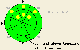
The avalanche danger is LOW for most elevations and aspects. Pockets of MODERATE danger still exist on NW-N-NE aspects, 35 degrees and steeper between 7,400' and 8,700'. Avalanches may be more difficult to trigger today; however, if triggered, they could be large and have serious consequences. |
|
|
|
Warm air and clouds ahead of an approaching low pressure system should keep temperatures mild and skies overcast today. As this system starts to impact the forecast area tonight, more clouds, increased winds and a slight chance of snow showers should develop. Starting tomorrow this system should bring .3-.6 inches of water to the area as rain rain below 7500' and 3-6 inches of snow above 8000'. The most intense periods of precipitation should occur during the afternoon. Precipitation should continue into next week as a series of colder storms moves through the forecast area. The forecast calls for snow levels to drop to around 5500' by Monday.
Yesterday, observations from the Bear Valley, Donner Summit, and Echo Summit areas all indicated a strengthening trend in the snowpack within the most recent snow, around the Feb. 22-23 rain crust, and in the snowpack above the Jan. 22-23 crust / facet layers. Tests also show that fracture propagation remains possible in the facet layer above the Jan. 22-23 crusts. However, initiating a fracture in this layer should be more difficult today. Observations from Incline Peak in the Mt. Rose area on Thurs. found a similar weak layer at the base of the Feb. snow that could be easier to trigger. A mix of breakable sun and wind crusts, hard wind slabs, and wind scoured snow exists on the snow surface on most aspects and elevations. Some pockets of unconsolidated soft snow still exist above 7500' on shaded, wind-protected, northerly aspects.
Today, deep slabs due to failure of the crust / facet layer at the base of the Feb. snow will continue to be the main avalanche concern. This layer should be more difficult to trigger today; however, if it fails, large and dangerous avalanches would result. Northerly aspects between 7400'-8700' that have steep, open, unsupported (for example: a cliff at the bottom of a steep slope), and rocky terrain will hold the best potential for triggering this persistent weak layer. Watch out for likely trigger points where a shallower snowpack exists, because it will be easier to break this layer in these locations. Once this layer starts to break, the fracture could propagate out into areas where a much thicker slab exists and result in very deep avalanches. Use caution when traveling in the backcountry today.
The avalanche danger is LOW for most elevations and aspects. Pockets of MODERATE danger still exist on NW-N-NE aspects, 35 degrees and steeper between 7,400' and 8,700'. Avalanches may be more difficult to trigger today; however, if triggered, they could be large and have serious consequences.
| 0600 temperature: | 26-30 deg. F. |
| Max. temperature in the last 24 hours: | 30-33 deg. F. |
| Average wind direction during the last 24 hours: | Southwest shifting to south after 1 am. |
| Average wind speed during the last 24 hours: | 18 mph |
| Maximum wind gust in the last 24 hours: | 39 mph |
| New snowfall in the last 24 hours: | O inches |
| Total snow depth: | 124 inches |
For 7000-8000 ft: |
|||
| Saturday: | Saturday Night: | Sunday: | |
| Weather: | Mostly cloudy | Cloudy with a slight chance of snow | Rain and snow with most intense precipitation developing in the afternoon. Snow level 7500 ft. |
| Temperatures: | 37-44 deg. F. | 22-29 deg. F. | 38-44 deg. F. |
| Wind direction: | South | South | South |
| Wind speed: | 10 increasing to 20-30 mph with gusts to 50 mph this afternoon | 15-25 mph with gusts to 35 mph | 20-30 mph with gusts to 45 mph |
| Expected snowfall: | O in. | O in. | .3-.6 in. of rain mixed with snow of 1-4 in. |
For 8000-9000 ft: |
|||
| Saturday: | Saturday Night: | Sunday: | |
| Weather: | Mostly cloudy | Cloudy with a slight chance of snow | Snow with most intense precipitation developing in the afternoon. Snow level 7500 ft. |
| Temperatures: | 33-40 deg. F. | 18-25 deg. F. | 31-37 deg. F. |
| Wind direction: | South | South | South - Southwest |
| Wind speed: | 20-30 mph with gusts to 50 mph | 30-45 mph with gusts to 75 mph | 35-50 mph with gusts to 85 mph |
| Expected snowfall: | O in. | O in. | 3-6 in. |


This website is owned and maintained by the non-profit arm of the Sierra Avalanche Center. Some of the content is updated by the USDA avalanche forecasters including the forecasts and some observational data. The USDA is not responsible for any advertising, fund-raising events/information, or sponsorship information, or other content not related to the forecasts and the data pertaining to the forecasts.

