In partnership with: 
|
March 5, 2009 at 7:53 am |
|
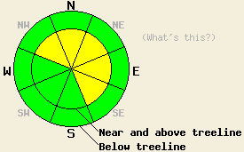
Near and above treeline, avalanche danger is MODERATE on NW-N-NE-E-SE aspects, 35 degrees and steeper. Below treeline, avalanche danger is LOW. |
|
|
|
A mix of sun and afternoon snow showers is expected today as moisture lingers over the forecast area. The storm system that affected the forecast area over the past few days left behind a total of 3 to 6 feet of new snow. Air temperatures this morning are in the teens at nearly all locations. Air temperatures are expected to rise into the 20s and low 30s today. Ridgetop winds remain moderate in speed from the southwest.
Yesterday, observations made on Jake's Peak (West Shore Tahoe area) indicated that a significant period of snowpack instability had occurred during the early morning hours. Evidence of widespread natural avalanche activity was visible below treeline between 7,000' and 9,000' on N-NE aspects steeper than 35 degrees. The instability occurred on a very subtle density change within the new snow with slab failure 8 inches deep in the snowpack. A couple inches of new snow covered the crowns and debris (photo 1, photo 2). This instability was later human triggered by the first group setting a skin track up the peak, with significant cracking and very small slab avalanches observed (photo 1, photo 2). This instability had stabilized by the afternoon hours. At the top of the peak in a near treeline area, a 2 foot crown and avalanche debris were visible from overnight natural avalanche activity at 9,380 on a wind loaded NE aspect, 37 degree slope. Light to moderate blowing snow was observed over ridgetops throughout the day, contributing to continued slab formation in wind loaded areas.
Snowpit data and stability tests taken on Jake's Peak at 7,600' on a NE aspect, 25 degree slope indicated that the entire height of the storm snow was rapidly bonding. Some minor faceting was observed above the March 1-2 rain crust at the base of the storm snow, but a significant weak layer had not yet formed. Snotel data from around the forecast area indicates that around 6 inches of settlement has occurred over the past 24 hours.
Today, human triggered avalanches remain possible near and above treeline in recently wind loaded areas, mainly on steep NW-N-NE-E-SE aspects. Continued SW winds and drifting snow have kept loading in these areas active. Instabilities that were observed yesterday in below treeline areas are expected to have stabilized. The newly formed rain crust that exists up to around 8,000' is the focus area of concern for developing instability over the next few days. We plan to watch this layer closely for developing faceted crystals and possible weak layer formation that could create another round of deep slab instability in the coming days. Some minor warming instability may occur today, especially in sun exposed areas below 7,500'. Roller balls created by snow falling from rocks and trees is the expected extent of warming instability for today.
Near and above treeline, avalanche danger is MODERATE on NW-N-NE-E-SE aspects, 35 degrees and steeper. Below treeline, avalanche danger is LOW.
| 0600 temperature: | 13 deg. F. |
| Max. temperature in the last 24 hours: | 23 deg. F. |
| Average wind direction during the last 24 hours: | Southwest |
| Average wind speed during the last 24 hours: | 30 mph |
| Maximum wind gust in the last 24 hours: | 50 mph |
| New snowfall in the last 24 hours: | 2 to 4 inches |
| Total snow depth: | 164 inches |
For 7000-8000 ft: |
|||
| Thursday: | Thursday Night: | Friday: | |
| Weather: | Partly cloudy skies in the morning, becoming mostly cloudy with isolated snow showers in the afternoon. | Cloudy skies with scattered snow showers. | Mostly cloudy skies with scattered snow showers. |
| Temperatures: | 29 to 35 deg. F. | 8 to 15 deg. F. | 27 to 33 deg. F. |
| Wind direction: | SW | W | NW |
| Wind speed: | Around 10 mph. | 15 to 25 mph with gusts to 35 mph. | 10 to 20 mph with gusts to 35 mph. |
| Expected snowfall: | 0 to trace in. | Trace to 1 in. | Trace in. |
For 8000-9000 ft: |
|||
| Thursday: | Thursday Night: | Friday: | |
| Weather: | Partly cloudy skies in the morning, becoming mostly cloudy with isolated snow showers in the afternoon. | Cloudy skies with scattered snow showers. | Mostly cloudy skies with scattered snow showers. |
| Temperatures: | 20 to 28 deg. F. | 4 to 11 deg. F. | 22 to 28 deg. F. |
| Wind direction: | SW | W | NW |
| Wind speed: | Around 10 mph. | 20 to 30 mph with gusts to 65 mph. | 20 to 30 mph with gusts to 55 mph. |
| Expected snowfall: | 0 to trace in. | Trace to 1 in. | Trace in. |


This website is owned and maintained by the non-profit arm of the Sierra Avalanche Center. Some of the content is updated by the USDA avalanche forecasters including the forecasts and some observational data. The USDA is not responsible for any advertising, fund-raising events/information, or sponsorship information, or other content not related to the forecasts and the data pertaining to the forecasts.

