In partnership with: 
|
March 10, 2009 at 6:46 am |
|
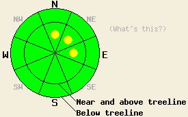
Near and above treeline avalanche danger is LOW with isolated pockets of MODERATE danger on N-NE-E aspects, 37 degrees and steeper. Below treeline, avalanche danger is LOW. |
|
|
|
High pressure is building over the forecast area this morning. Sunny skies and light winds are forecast for today. Yesterday's weather disturbance brought 2 to 3 inches of new snow to the northeastern portion of the forecast area. New snow amounts dropped off significantly in the western and southern portions of the portions of the area due to the track of the system. Air temperatures fell into the teens to single digits in nearly all locations last night under clear skies. Air temperatures are expected to rise into the 20s to low 30s today. Ridgetop winds shifted from SW to W yesterday afternoon and then to NE overnight. Wind speeds decreased to light overnight and remain light this morning.
Yesterday, observations made on Incline Lake Peak (Mount Rose area) revealed stable snow and minimal effects from wind. This was not at all consistent with the hurricane force winds and significant amounts of blowing snow that had been observed on Sunday in the Donner Summit area and in other portions of the Mount Rose area. Snow surface conditions are very dependent on aspect, with the highest quality snow found below treeline on N-NE aspects. Southerly aspects hold supportable or breakable crust at nearly all elevations.
Today, a stable snowpack will exist in most areas. However, isolated unstable slabs are expected to linger near and above treeline in recently wind loaded areas on N-NE-E aspects. These slabs may be difficult to trigger and will be found within areas that appear to have generally stable snowpack conditions. If triggered, an avalanche may be large enough to bury a person due to the size of the slab. Light NE ridgetop winds overnight are expected to have had only a minimal scouring effect on these slopes. Use good travel habits and conservative terrain choices to minimize risk.
Near and above treeline avalanche danger is LOW with isolated pockets of MODERATE danger on N-NE-E aspects, 37 degrees and steeper. Below treeline, avalanche danger is LOW.
| 0600 temperature: | 12 to 18 deg. F. |
| Max. temperature in the last 24 hours: | 16 to 20 deg. F. |
| Average wind direction during the last 24 hours: | SW shifting to NE |
| Average wind speed during the last 24 hours: | 22 mph |
| Maximum wind gust in the last 24 hours: | 62 mph |
| New snowfall in the last 24 hours: | 0 to 1 inches |
| Total snow depth: | 150 inches |
For 7000-8000 ft: |
|||
| Tuesday: | Tuesday Night: | Wednesday: | |
| Weather: | Sunny skies in the morning, becoming partly cloudy. | Partly cloudy skies. | Partly cloudy skies. |
| Temperatures: | 27 to 34 deg. F. | 7 to 14 deg. F. | 29 to 36 deg. F. |
| Wind direction: | NE | NE shifting to SE | Variable |
| Wind speed: | Around 10 mph in the morning, becoming light. | Around 10 mph. | Light winds. |
| Expected snowfall: | O in. | O in. | O in. |
For 8000-9000 ft: |
|||
| Tuesday: | Tuesday Night: | Wednesday: | |
| Weather: | Sunny skies in the morning, becoming partly cloudy. | Partly cloudy skies. | Partly cloudy skies. |
| Temperatures: | 22 to 29 deg. F. | 7 to 14 deg. F. | 28 to 34 deg. F. |
| Wind direction: | NE | NE shifting to SE | Variable |
| Wind speed: | 10 to 20 mph with gusts to 30 mph in the morning. | Around 10 mph. | Light winds. |
| Expected snowfall: | O in. | O in. | O in. |


This website is owned and maintained by the non-profit arm of the Sierra Avalanche Center. Some of the content is updated by the USDA avalanche forecasters including the forecasts and some observational data. The USDA is not responsible for any advertising, fund-raising events/information, or sponsorship information, or other content not related to the forecasts and the data pertaining to the forecasts.

