In partnership with: 
|
March 13, 2009 at 6:43 am |
|
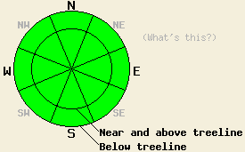
Avalanche danger is LOW for all elevations and aspects. LOW danger does not mean no danger. Continue to use safe travel habits and evaluated slopes carefully before weighting them. |
|
|
|
A small, high-pressure ridge remains over the forecast area and should keep skies clear and temperatures warm today. The winds should start to increase and shift to the southwest and west over the next 24 hours as a low-pressure system moves into the Pacific Northwest. This system should bring some cloud cover to the forecast area starting this evening. By tomorrow more clouds should arrive and temperatures should cool slightly.
Settlement and consolidation in the snowpack continue across the forecast area. Observations show cold, soft powder on N-NE aspects above 7000' that have been protected from the wind and sun. On E-SE-S-SW-W aspects, the sun and warm temperatures cause the snow to melt during the day. For a few hours during the afternoon 1-3 inches of soft wet snow exists on these aspects up to about 8500'. The clear, cold nights allow this wet surface snow to re-freeze leaving a hard icy surface on these aspects in the mornings. Breakable crusts, and supportable crusts exist on many E and NW aspects. Above treeline hard, wind-packed surfaces and hard, wind-scoured surfaces exist on almost all aspects that were exposed to the winds during the last storm. Yesterday, observations on Mt. Judah showed a mostly stable and strengthening snowpack. Layer bonding tests showed that the bonds between the wind slabs and the snow below them continue to gain strength. In most areas these bonds are strong enough to hold the slab in place. Observations from across the forecast area this week have shown similar conditions.
Today, avalanche activity will remain unlikely across the forecast area. Some small, wet-snow instabilities like point releases, pin-wheels, or roller-balls could form on the most sun exposed SE-S-SW slopes. The gradual warming and strong overnight refreezes should prevent large wet-snow instabilities from forming today. Remember LOW avalanche danger does not mean no avalanche danger. Even though the snowpack is generally stable, some small, isolated areas of unstable snow could still exist. Use good travel habits to minimize risks.
Avalanche danger is LOW for all elevations and aspects. LOW danger does not mean no danger. Continue to use safe travel habits and evaluated slopes carefully before weighting them.
| 0600 temperature: | 21 deg. F. |
| Max. temperature in the last 24 hours: | 36 deg. F. |
| Average wind direction during the last 24 hours: | East |
| Average wind speed during the last 24 hours: | 30 mph |
| Maximum wind gust in the last 24 hours: | 45 mph |
| New snowfall in the last 24 hours: | O inches |
| Total snow depth: | 146 inches |
For 7000-8000 ft: |
|||
| Friday: | Friday Night: | Saturday: | |
| Weather: | Sunny | Clear this evening becoming partly cloudy after midnight | Mostly cloudy |
| Temperatures: | 39-46 deg. F. | 16-23 deg. F. | 37-44 deg. F. |
| Wind direction: | East shifting to the southwest in the afternoon | Southwest | West |
| Wind speed: | 10 mph | 10 mph | 20-30 mph with gusts to 35 mph |
| Expected snowfall: | O in. | O in. | O in. |
For 8000-9000 ft: |
|||
| Friday: | Friday Night: | Saturday: | |
| Weather: | Sunny | Clear this evening becoming partly cloudy after midnight | Mostly cloudy |
| Temperatures: | 38-44 deg. F. | 16-23 deg. F. | 36-42 deg. F. |
| Wind direction: | East shifting to the southwest in the afternoon | Southwest | West |
| Wind speed: | 15-20 mph with gusts to 40 mph decreasing to 10-15 mph | 10-15 mph with gusts to 25 mph | 20-30 mph with gusts to 45 mph increasing to gusts to 55 mph in the afternoon |
| Expected snowfall: | O in. | O in. | O in. |


This website is owned and maintained by the non-profit arm of the Sierra Avalanche Center. Some of the content is updated by the USDA avalanche forecasters including the forecasts and some observational data. The USDA is not responsible for any advertising, fund-raising events/information, or sponsorship information, or other content not related to the forecasts and the data pertaining to the forecasts.

