In partnership with: 
|
March 19, 2009 at 7:00 am |
|
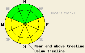
The avalanche danger is LOW on NW-N-NE aspects. On E-SE-S-SW-W aspects, the avalanche danger will increase to MODERATE on slopes steeper than 35 degrees for all elevations due to daytime warming. |
|
|
|
Thin, high clouds developed across the forecast area overnight. These clouds should persist through tonight before some clearing on Friday. Last night this blanket of clouds kept temperatures in the mid to upper 30's up to 9000' across the region. These clouds should remain thin and will trap heat over the forecast area again today. The southwest winds should start to increase today and should continue to strengthen as a low pressure system begins to approach the forecast area. This system could bring winter back to the forecast area this weekend.
Yesterday observations near Carson Pass showed firm, wind-affected snow on the open NW-N-NE aspects near and above treeline. Some soft snow existed in areas protected from the sun and wind on these aspects above 8000'. Below 8000' a sometimes supportable, sometimes breakable rain crust existed on any aspects where the sun had not melted it. Sun-exposed, E-SE-S aspects up to 9200' had 1-3 inches of soft melt/freeze snow on the surface by 11am. The sun-exposed, SW-W aspects softened just a little later in the day. By mid afternoon some pinwheels and roller-balls had occurred on steep, sun-drenched, southerly aspects between Carson Pass and Emerald Bay. No other avalanche activity was reported. Layer-bonding tests near Carson Pass showed good bonding between the hard wind slabs and the snow below them. Snowpit observations on a SE aspect at 8900' showed that the active melt/freeze process has only affected the upper 10-15 inches of the snowpack. Cold, dry snow still exists below this upper melt/freeze layer.
Today, the main avalanche concern will be wet-snow instabilities. The high, thin clouds over the area should still allow solar radiation to reach the surface and melt snow today. These clouds should also prevent heat radiating off the snow surface from escaping into the atmosphere today. This blanket of clouds will work with the intense March sun, warm daytime temperatures, and overnight temperatures above freezing to accelerate and lengthen the melting phase of the melt/freeze cycle today. The water produced by melting snow will quickly melt the bonds holding the snowpack together and weaken the snowpack. The snowpack could weaken to the point that a person moving across the snow could overload the snowpack and cause it to fail today. Wet-slab avalanches as well as other minor wet snow instabilities like pinwheels, roller-balls, and wet point-release avalanches will all remain possible today. They will be most prevalent on the E-SE-S-SW-W aspects. Some pinwheels and point-releases could occur on northerly aspects where soft snow exists today. These wet-snow instabilities will persist until the snowpack refreezes.
The avalanche danger is LOW on NW-N-NE aspects. On E-SE-S-SW-W aspects, the avalanche danger will increase to MODERATE on slopes steeper than 35 degrees for all elevations due to daytime warming.
| 0600 temperature: | 37 deg. F. |
| Max. temperature in the last 24 hours: | 47 deg. F. |
| Average wind direction during the last 24 hours: | Southwest |
| Average wind speed during the last 24 hours: | 10 mph |
| Maximum wind gust in the last 24 hours: | 27 mph |
| New snowfall in the last 24 hours: | O inches |
| Total snow depth: | 144 inches |
For 7000-8000 ft: |
|||
| Thursday: | Thursday Night: | Friday: | |
| Weather: | Mostly cloudy with a slight chance for some isolated showers this afternoon | Mostly cloudy with a slight chance for some isolated showers this evening becoming partly cloudy after midnight | Partly cloudy |
| Temperatures: | 49-56 deg. F. | 32-38 deg. F. | 48-55 deg. F. |
| Wind direction: | Southwest | Southwest | Southwest |
| Wind speed: | 10-15 mph | 10-15 mph | 10-20 mph with gusts to 30 mph |
| Expected snowfall: | O in. | O in. | O in. |
For 8000-9000 ft: |
|||
| Thursday: | Thursday Night: | Friday: | |
| Weather: | Mostly cloudy with a slight chance for some isolated showers this afternoon | Mostly cloudy with a slight chance for some isolated showers this evening becoming partly cloudy after midnight | Partly cloudy |
| Temperatures: | 44-50 deg. F. | 33-38 deg. F. | 43-49 deg. F. |
| Wind direction: | Southwest | Southwest | Southwest |
| Wind speed: | 10-20 mph with gusts to 35 mph | 10-20 mph with gusts to 35 mph | 10-15 mph with gusts to 30 mph increasing to 20-30 mph with gusts to 40 mph in the afternoon |
| Expected snowfall: | O in. | O in. | O in. |


This website is owned and maintained by the non-profit arm of the Sierra Avalanche Center. Some of the content is updated by the USDA avalanche forecasters including the forecasts and some observational data. The USDA is not responsible for any advertising, fund-raising events/information, or sponsorship information, or other content not related to the forecasts and the data pertaining to the forecasts.

