In partnership with: 
|
March 20, 2009 at 6:57 am |
|
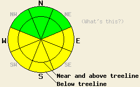
This morning the avalanche danger is LOW for all aspects and elevations. On E-SE-S-SW-W aspects, the avalanche danger will quickly rise to MODERATE on slopes steeper than 35 degrees for all elevations due to daytime warming. |
|
|
|
The forecast calls for another warm, sunny day over the forecast area. Some clouds should start to develop later this afternoon as a low pressure system from the Gulf of Alaska begins migrating towards the Sierra. The southwest winds should begin to increase ahead of this system. Temperatures should also drop starting tonight due to the approaching system. The NWS has issued a winter storm watch for the area over the weekend.
Temperatures have remained above freezing since around 8 am on the 18th. These warm temperatures combined with some overnight cloud cover prevented a strong refreeze overnight on the 18th. Yesterday, the snow surface softened much more quickly and more widespread melting occurred as a result of the weak refreeze, the March sun, and the warm temperatures. On Jake's Peak 2-3 inches of soft, wet snow already existed on the surface on sun-exposed E-SE-S aspects by 10am yesterday. By 11am 5-7 inches of wet, soft snow had formed on these aspects. After 11am some human-triggered pinwheels and roller-balls occurred on these slopes. Similar melt/freeze conditions existed on the SW-W aspects. The snow on these aspects softened slightly after the snow on the E-SE-S aspects. The sometimes supportable, sometimes breakable rain crust persisted on most NW-N-NE aspects up to 8500'. Above 8500' firm wind-affected snow remained widespread on these aspects. Very small, isolated pockets of soft snow existed on the N-NE aspects that have remained protected from the wind and sun and above the rain line.
Today, the main avalanche concern will be wet-snow instabilities. Last night's clear skies and slightly cooler temperatures should have allowed the snowpack to undergo a stronger refreeze than it did yesterday. However, the March sun combined with even warmer daytime temperatures should quickly melt snow and prolong the melting phase of the melt/freeze cycle today. The water produced by melting snow will melt the bonds holding the snowpack together and weaken the snowpack. The snowpack could weaken to the point that a person moving across the snow could overload the snowpack and cause it to fail today. Wet-slab avalanches as well as other wet snow instabilities like pinwheels, roller-balls, and wet point-release avalanches will all remain possible today. They will be most prevalent on the E-SE-S-SW-W aspects. More widespread clouds this afternoon could help limit the melting phase of the melt/freeze cycle. These wet-snow instabilities will persist until the snowpack refreezes.
This morning the avalanche danger is LOW for all aspects and elevations. On E-SE-S-SW-W aspects, the avalanche danger will quickly rise to MODERATE on slopes steeper than 35 degrees for all elevations due to daytime warming.
| 0600 temperature: | 34 deg. F. |
| Max. temperature in the last 24 hours: | 48 deg. F. |
| Average wind direction during the last 24 hours: | Southwest |
| Average wind speed during the last 24 hours: | 20 mph |
| Maximum wind gust in the last 24 hours: | 35 mph |
| New snowfall in the last 24 hours: | O inches |
| Total snow depth: | 142 inches |
For 7000-8000 ft: |
|||
| Friday: | Friday Night: | Saturday: | |
| Weather: | Sunny in the morning, becoming partly cloudy this afternoon | Mostly cloudy with a slight chance of showers | Cloudy with a chance of snow showers |
| Temperatures: | 50-60 deg. F. | 28-35 deg. F. | 36-44 deg. F. |
| Wind direction: | Southwest | Southwest | Southwest |
| Wind speed: | 5-15 mph | 10-20 mph with gusts to 40 mph | 20-35 mph with gusts to 60 mph |
| Expected snowfall: | O in. | O in. | up to 1 in. |
For 8000-9000 ft: |
|||
| Friday: | Friday Night: | Saturday: | |
| Weather: | Sunny in the morning, becoming partly cloudy | Mostly cloudy with a slight chance of showers | Cloudy with a chance of snow showers |
| Temperatures: | 40-50 deg. F. | 25-35 deg. F. | 31-41 deg. F. |
| Wind direction: | Southwest | Southwest | Southwest |
| Wind speed: | 10-15 mph with gusts to 25 mph increasing to 15-25 mph with gusts to 40 mph this afternoon | 15-25 mph with gusts to 35 mph increasing to 25-35 mph with gusts to 60 mph after midnight | 25-35 mph increasing to 40-50 mph with gusts between 70-90 mph in the afternoon |
| Expected snowfall: | O in. | O in. | up to 1 in. |


This website is owned and maintained by the non-profit arm of the Sierra Avalanche Center. Some of the content is updated by the USDA avalanche forecasters including the forecasts and some observational data. The USDA is not responsible for any advertising, fund-raising events/information, or sponsorship information, or other content not related to the forecasts and the data pertaining to the forecasts.

