In partnership with: 
|
March 22, 2009 at 6:56 am |
|
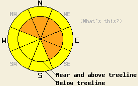
Near and above treeline, avalanche danger is CONSIDERABLE on NW-N-NE-E-SE aspects, 35 degrees and steeper. Below treeline, avalanche danger is MODERATE in open areas, 35 degrees and steeper. |
|
|
|
The storm system currently affecting the forecast area is expected to continue through this morning before tapering off this afternoon. High intensity snowfall with accumulation rates up to three inches per hour are expected to continue until around 8 am. Snowfall intensity is then forecast to ease back to shower activity, eventually stopping sometime between 10 am and 2 pm. Storm totals are running 12 to 20 inches with the greatest accumulations north of Hwy 88. Nearly all of this snow has accumulated in the past 15 hours. Air temperatures this morning above 7,000' are in the teens and low 20s. After warming a degree or two this morning, air temperatures are expected to fall throughout the day. Ridgetop winds have decreased from strong to moderate in speed this morning and remain out of the southwest. Ridgetop winds are forecast to shift to the northwest this afternoon.
Yesterday, observations made on Jake's Peak (West Shore Tahoe) and on Mt. Judah (Donner Summit area) both revealed some softening of surface snow below 8,500' and poorly refrozen wet snow below 7,000'. By early to late afternoon, new snowfall and blowing snow were present. Cornice features began to build and were fairly weak. New snow appeared to bond well to the old snow surface, especially in areas that were wet.
Overnight, snowfall rates were steady at around 1/3 to 1/2 inch per hour. Around 2 am, snowfall rates increased to 2 to 3 inches per hour and a slight warming of air temperatures occurred. This spike in air temperatures and dramatic increase in snowfall intensity is expected to have created a weak layer within the new snow.
Natural and human triggered avalanches are expected today, especially in the early morning hours prior to 8 am. Once snowfall intensity eases to showers, the best window for natural avalanche activity will have passed. Evidence of natural avalanche activity will likely be seen in the backcountry today. Continued light snowfall and shifting winds will allow wind loading and slab formation to continue well into this evening. Human triggered avalanches that are large enough to bury a person will remain probable throughout the day. A lingering possibility of natural avalanches will remain in the most heavily wind loaded areas on NW-N-NE-E-SE aspects. Snowpack failure today is expected to occur within the new snow, but could possibly entrain old wet snow below the storm snow in lower elevation areas.
Near and above treeline, avalanche danger is CONSIDERABLE on NW-N-NE-E-SE aspects, 35 degrees and steeper. Below treeline, avalanche danger is MODERATE in open areas, 35 degrees and steeper.
| 0600 temperature: | 17 deg. F. |
| Max. temperature in the last 24 hours: | 33 deg. F. |
| Average wind direction during the last 24 hours: | Southwest |
| Average wind speed during the last 24 hours: | 45 mph |
| Maximum wind gust in the last 24 hours: | 90 mph |
| New snowfall in the last 24 hours: | 11 to 20 inches |
| Total snow depth: | 153 inches |
For 7000-8000 ft: |
|||
| Sunday: | Sunday Night: | Monday: | |
| Weather: | Cloudy skies with high intensity snowfall in the morning. Mostly cloudy skies with snow showers in the afternoon. | Mostly cloudy skies with scattered snow showers in the evening. Partly cloudy skies with isolated snow showers after midnight. | Partly cloudy skies. |
| Temperatures: | 20 to 30 deg. F. | 10 to 20 deg. F. | 28 to 38 deg. F. |
| Wind direction: | SW shifting to NW | NW shifting to NE | NE |
| Wind speed: | 10 to 20 mph with gusts to 40 mph. | 10 to 20 mph, decreasing to 10 to 15 mph after midnight. Gusts to 35 mph. | 10 to 15 mph with gusts to 30 mph. |
| Expected snowfall: | In the early morning, 5 to 10 in. | 0 to 1 in. | O in. |
For 8000-9000 ft: |
|||
| Sunday: | Sunday Night: | Monday: | |
| Weather: | Cloudy skies with high intensity snowfall in the morning. Mostly cloudy skies with snow showers in the afternoon. | Mostly cloudy skies with scattered snow showers in the evening. Partly cloudy skies with isolated snow showers after midnight. | Partly cloudy skies. |
| Temperatures: | Falling through the day, 14 to 20 deg. F. | 6 to 16 deg. F. | 18 to 28 deg. F. |
| Wind direction: | SW shifting to NW | NW shifting to E | NE shifting to N |
| Wind speed: | 20 to 35 mph with gusts to 65 mph. | 25 to 35 mph with gusts to 55 mph. Decreasing to 20 to 30 mph with gusts to 45 mph after midnight. | 30 to 40 mph with gusts to 65 mph. Decreasing to 15 to 25 mph with gusts to 55 mph in the afternoon. |
| Expected snowfall: | In the early morning, 6 to 10 in. | 0 to 1 in. | O in. |


This website is owned and maintained by the non-profit arm of the Sierra Avalanche Center. Some of the content is updated by the USDA avalanche forecasters including the forecasts and some observational data. The USDA is not responsible for any advertising, fund-raising events/information, or sponsorship information, or other content not related to the forecasts and the data pertaining to the forecasts.

