In partnership with: 
|
March 23, 2009 at 6:51 am |
|
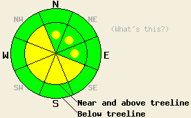
Near and above treeline, areas of MODERATE avalanche danger exist on all aspects, 35 degrees and steeper. Below treeline, avalanche danger is LOW. |
|
|
|
The storm system that affected the forecast area yesterday has moved off to the east and left clear skies over the area this morning. Storm totals are generally 1.5 to 2 feet with local amounts up to 2.5 feet across the forecast area. Air temperatures in the single digits and low teens this morning will remain cool today, climbing only into the teens and 20s in most locations. Ridgetop winds shifted from SW to NE overnight and are expected to remain moderate to strong in speed through this evening.
Yesterday, observations made on Mt. Judah and Donner Peak (Donner Summit area) revealed instability within the new snow. Evidence of small natural avalanches from the early morning hours was observed near and above treeline on a variety of N-NE-E-SE aspects, steeper than 35 degrees, between 7,200 and 8,400'. Below treeline, some skier triggered whumpfing but no cracking was observed. The snowpack was observed to fail within the new snow in all natural avalanches, human triggered test slopes, and stability tests. Good bonding of new snow to the melt-freeze crust at the base of the storm snow was observed. On Hidden Peak (West Shore Tahoe), similar instability was reported. Small natural avalanches had occurred during the early morning hours on steep N-NE aspects below treeline between 7,800' and 8,400'. Above treeline around 9,000', continued wind loading allowed for shooting cracks and test slope failures on steep N-NE aspects. This morning, remote sensors report up to 8 inches of settlement has occurred within the storm snow.
Today, northeast winds are expected to cause significant redistribution of snow in near and above treeline areas. Generally, scouring of new snow will occur on northerly and easterly aspects and wind loading will occur on southerly and westerly aspects. This redistributed snow is expected to rapidly form new slabs in lee areas. Human triggered avalanche activity should be expected today in wind loaded areas. On NW and SE aspects that have been cross loaded by both the recent SW storm winds and today's NE winds, larger avalanches are possible.
With cool air temperatures today, widespread warming instability is not expected. Some isolated areas of warming instability are unlikely but not impossible this afternoon on southerly aspects in steep open areas below 7,000'. Due to the relatively small amounts of new snow in these areas, this is not expected to present a significant hazard to backcountry travelers.
Near and above treeline, areas of MODERATE avalanche danger exist on all aspects, 35 degrees and steeper. Below treeline, avalanche danger is LOW.
| 0600 temperature: | 11 deg. F. |
| Max. temperature in the last 24 hours: | 18 deg. F. |
| Average wind direction during the last 24 hours: | Southwest shifting to northeast. |
| Average wind speed during the last 24 hours: | 35 mph |
| Maximum wind gust in the last 24 hours: | 65 mph |
| New snowfall in the last 24 hours: | 6 to 10 inches |
| Total snow depth: | 152 inches |
For 7000-8000 ft: |
|||
| Monday: | Monday Night: | Tuesday: | |
| Weather: | Partly cloudy skies. | Partly cloudy skies in the evening, becoming mostly cloudy. | Partly cloudy skies. |
| Temperatures: | 24 to 31 deg. F. | 20 to 26 deg. F. | 27 to 34 deg. F. |
| Wind direction: | NE shifting to N in the afternoon. | NE | NE |
| Wind speed: | Around 10 mph with gusts to 30 mph. | 10 to 15 mph with gusts to 25 mph in the evening. | 10 to 15 mph with gusts to 25 mph. |
| Expected snowfall: | O in. | O in. | O in. |
For 8000-9000 ft: |
|||
| Monday: | Monday Night: | Tuesday: | |
| Weather: | Partly cloudy skies. | Partly cloudy skies in the evening, becoming mostly cloudy. | Partly cloudy skies. |
| Temperatures: | 15 to 25 deg. F. | 14 to 24 deg. F. | 22 to 32 deg. F. |
| Wind direction: | NE shifting to N in the afternoon. | N | NE |
| Wind speed: | 30 to 40 mph with gusts to 60 mph. Decreasing to 15 to 25 mph with gusts to 55 mph in the afternoon. | 15 to 25 mph with gusts to 45 mph. | 20 to 30 mph with gusts to 45 mph. |
| Expected snowfall: | O in. | O in. | O in. |


This website is owned and maintained by the non-profit arm of the Sierra Avalanche Center. Some of the content is updated by the USDA avalanche forecasters including the forecasts and some observational data. The USDA is not responsible for any advertising, fund-raising events/information, or sponsorship information, or other content not related to the forecasts and the data pertaining to the forecasts.

