In partnership with: 
|
March 26, 2009 at 7:01 am |
|
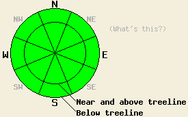
Today, the avalanche danger is LOW for all elevations and aspects. Small, wet-snow instabilities may develop due to daytime warming on the sun-exposed E-SE-S-SW-W aspects 37 degrees and steeper below treeline today. |
|
|
|
A cold front moving south and east through NV should keep temperatures much cooler today. The forecast calls for daytime highs to occur this morning before the temperatures start to fall into the mid and upper 20's above 7000' this afternoon. The winds should shift back to the north and east and increase due to a high-pressure ridge following this cold front. By tomorrow this ridge should bring sunny skies and much warmer temperatures to the forecast area.
Over the last 2-3 days observers have reported several point-release avalanches on steep E-SE-S facing sun-exposed slopes in the Desolation Wilderness (photo), the Mt. Rose backcountry, near Emerald Bay, and along the West Shore. None of these slides have entrained enough snow to bury a person; however, they have been large enough to knock someone off balance. No wet slab avalanches have been reported. Yesterday, more cloud cover and cooler temperatures prevented any large, widespread wet snow instabilities from forming. Observations on Rubicon Peak showed sun crusts and wet, sticky surface snow on all aspects up to 8000' yesterday. On the sun-exposed E-SE-S-SW aspects, these conditions existed up to at least 9000'. Soft snow still existed beneath the breakable sun crusts and wet surface snow on these southerly aspects. A few more days of melting and refreezing should create a thick, supportable melt/freeze layer that softens enough to provide good riding conditions for a few hours during the day. On the shaded northerly aspects above 8000', the surface snow remains soft and unconsolidated. Layer bonding tests and snowpit observations showed a mostly stable snowpack below the surface.
The strong overnight refreeze, daytime temperatures in the 20's, strong northerly winds, and some morning cloud cover should all work together to keep the snow surface frozen longer today. Some small point-release avalanches, roller-balls, and pinwheels could still occur on the most sun-exposed E-SE-S-SW-W aspects below treeline today. If the temperatures rise more than expected and the clouds dissipate faster than expected, these instabilities could become larger and more widespread.
Today, the avalanche danger is LOW for all elevations and aspects. Small, wet-snow instabilities may develop due to daytime warming on the sun-exposed E-SE-S-SW-W aspects 37 degrees and steeper below treeline today.
| 0600 temperature: | 31 deg. F. |
| Max. temperature in the last 24 hours: | 38 deg. F. |
| Average wind direction during the last 24 hours: | West shifting to the north |
| Average wind speed during the last 24 hours: | 25 mph |
| Maximum wind gust in the last 24 hours: | 55 mph |
| New snowfall in the last 24 hours: | O inches |
| Total snow depth: | 147 inches |
For 7000-8000 ft: |
|||
| Thursday: | Thursday Night: | Friday: | |
| Weather: | Partly cloudy this morning then clearing throughout the day | Clear | Sunny |
| Temperatures: | 28-38 deg. F. | 18-28 deg. F. | 40-50 deg. F. |
| Wind direction: | North shifting to the northeast | Northeast | Northeast |
| Wind speed: | 10-20 mph with gusts to 35 mph | 15-25 mph with gusts to 35 mph decreasing to 10-15 mph with gusts to 25 mph after midnight | 10 mph |
| Expected snowfall: | O in. | O in. | O in. |
For 8000-9000 ft: |
|||
| Thursday: | Thursday Night: | Friday: | |
| Weather: | Partly cloudy this morning then clearing throughout the day | Clear | Sunny |
| Temperatures: | 28-34 deg. F. falling during the day to 21-27 deg. F. | 14-21 deg. F. | 35-45 deg. F. |
| Wind direction: | North shifting to the northeast | Northeast shifting to the east | East |
| Wind speed: | 20-40 mph with gusts to 50-70 mph | 30-45 mph with gusts to 55-75 mph | 10-20 mph with gusts to 40 mph |
| Expected snowfall: | O in. | O in. | O in. |


This website is owned and maintained by the non-profit arm of the Sierra Avalanche Center. Some of the content is updated by the USDA avalanche forecasters including the forecasts and some observational data. The USDA is not responsible for any advertising, fund-raising events/information, or sponsorship information, or other content not related to the forecasts and the data pertaining to the forecasts.

