In partnership with: 
|
April 5, 2009 at 6:40 am |
|
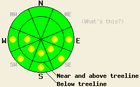
This morning, avalanche danger is LOW for all elevations and aspects. Pockets of MODERATE danger will form at all elevations on E-SE-S-SW-W aspects, 35 degrees and steeper in response to daytime warming. |
|
|
|
A high-pressure ridge should bring warm, sunny, spring weather back to the forecast area today. The forecast calls for daytime highs to increase by 5-10 deg. F. over yesterday's high temperatures. The winds should also decrease and continue shifting towards the south. This warm, spring weather should continue until the next low-pressure system begins to impact the forecast area Monday afternoon and evening.
Yesterday, cool daytime highs, moderate northerly winds, and a strong refreeze from Friday night kept the snow surface frozen for most of the day. In the Mt. Judah area, the intense, springtime sun did manage to soften the E-SE-S-SW aspects by noon. 2-3 inches of wet, soft, melt-freeze (corn) snow existed on these aspects on sun-exposed slopes until about 4 pm when the snow started to refreeze. Observers reported some small roller-balls below treeline due to ski-cutting between 1 and 2 pm. A mix of hard, wind-affected snow surfaces, "dust on crust," and just plain crusts existed on the NW-N-NE aspects. No avalanche activity was reported yesterday.
Daytime highs in the mid to upper 40's at all elevations, clear sunny skies, and light southerly winds should all tip the balance in favor of the melting phase of the melt-freeze process. The snowpack should soften faster and melting should penetrate to greater depths today. More melting means more free water in the snowpack. More free water means more of the bonds holding the snowpack together will dissolve making the snowpack weaker. By this afternoon enough melting could occur for wet-snow instabilities to form on steep, sun-exposed E-SE-S-SW-W aspects at all elevations. Last night's strong overnight refreeze and well established drainage channels that efficiently move melt water through the snowpack to the ground should help keep these wet snow instabilities from becoming large and widespread today. Use clues like sinking into wet snow up to the top of your boots or seeing / triggering pinwheels and roller balls to help decide which slopes to avoid. If you see these things it may be time to move to more northerly aspects or lower angle terrain.
This morning, avalanche danger is LOW for all elevations and aspects. Pockets of MODERATE danger will form at all elevations on E-SE-S-SW-W aspects, 35 degrees and steeper in response to daytime warming.
| 0600 temperature: | 26 deg. F. |
| Max. temperature in the last 24 hours: | 40 deg. F. |
| Average wind direction during the last 24 hours: | East northeast shifting to the south and southeast |
| Average wind speed during the last 24 hours: | 20 mph |
| Maximum wind gust in the last 24 hours: | 51 mph |
| New snowfall in the last 24 hours: | O inches |
| Total snow depth: | 138 inches |
For 7000-8000 ft: |
|||
| Sunday: | Sunday Night: | Monday: | |
| Weather: | Sunny | Clear | Sunny in the morning becoming partly cloudy in the afternoon |
| Temperatures: | 40-47 deg. F. | 19-26 deg. F. | 44-51 deg. F. |
| Wind direction: | Southeast | South | Southeast |
| Wind speed: | 10 mph | 10 mph | 10-20 mph with gusts to 30 mph |
| Expected snowfall: | O in. | O in. | O in. |
For 8000-9000 ft: |
|||
| Sunday: | Sunday Night: | Monday: | |
| Weather: | Sunny | Clear | Sunny in the morning becoming partly cloudy in the afternoon |
| Temperatures: | 40-46 deg. F. | 19-26 deg. F. | 42-48 deg. F. |
| Wind direction: | Southeast | South | Southeast |
| Wind speed: | 10-15 mph | 15-25 mph with gusts to 40 mph | 15-25 mph with gusts to 45 mph |
| Expected snowfall: | O in. | O in. | O in. |


This website is owned and maintained by the non-profit arm of the Sierra Avalanche Center. Some of the content is updated by the USDA avalanche forecasters including the forecasts and some observational data. The USDA is not responsible for any advertising, fund-raising events/information, or sponsorship information, or other content not related to the forecasts and the data pertaining to the forecasts.

