In partnership with: 
|
April 6, 2009 at 6:58 am |
|
This morning, avalanche danger is LOW for all elevations and aspects. Pockets of MODERATE danger will form at all elevations on E-SE-S-SW-W aspects, 35 degrees and steeper in response to daytime warming. |
|
|
|
A low-pressure system off the CA coast should begin to slowly push the high-pressure ridge out of the forecast area today. By this afternoon some cloud cover should start to develop over the region. These clouds should become more widespread overnight as the low-pressure system moves closer to the forecast area. This system should also bring cooler temperatures and a chance for some isolated snow showers to the area by Tuesday afternoon. The temperatures should remain warm today.
Yesterday, observations near Kirkwood and near the summit of Carson Pass showed 2-3 inches of wet, soft, melt-freeze (corn) snow on the E-SE-S-SW-W aspects by 11 am. On Carson Pass 4-8 inches of wet snow had formed on the surface of these aspects by 4 pm. A mix of hard, wind-affected snow surfaces, "dust on crust," and just plain crusts existed on the NW-N-NE aspects. No avalanche activity was reported yesterday.
Continued sunny skies, daytime highs in upper 40's to low 50's at all elevations, and light southerly winds should cause the snowpack to soften quickly today. These factors should also allow more melting, and melt water should penetrate to greater depths in the snowpack. As the bonds holding the snowpack together melt, expect the layers of snow near the surface to lose strength and become unconsolidated. By this afternoon enough melting could occur for wet-snow instabilities to form on steep, sun-exposed E-SE-S-SW-W aspects at all elevations. Strong overnight refreezes over the last few days and well-established drainage channels that move melt water through the snowpack to the ground should help keep these wet snow instabilities from becoming large and widespread today. Use clues like sinking into wet snow up to the top of your boots or seeing / triggering pinwheels and roller balls to help decide which slopes to avoid. If you see these things, it may be time to move to safer locales like more northerly aspects or lower angle terrain. If cloud cover increases enough to limit the amount of sunlight reaching the snow surface, less melting and softening should take place, and slopes should remain more frozen.
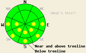
This morning, avalanche danger is LOW for all elevations and aspects. Pockets of MODERATE danger will form at all elevations on E-SE-S-SW-W aspects, 35 degrees and steeper in response to daytime warming.
| 0600 temperature: | 31 deg. F. |
| Max. temperature in the last 24 hours: | 46-50 deg. F. |
| Average wind direction during the last 24 hours: | East southeast |
| Average wind speed during the last 24 hours: | 20 mph |
| Maximum wind gust in the last 24 hours: | 37 mph |
| New snowfall in the last 24 hours: | O inches |
| Total snow depth: | 137 inches |
For 7000-8000 ft: |
|||
| Monday: | Monday Night: | Tuesday: | |
| Weather: | Sunny in the morning becoming partly cloudy this afternoon | Mostly cloudy | Mostly cloudy with a chance of snow showers developing by the afternoon |
| Temperatures: | 44-51 deg. F. | 21-28 deg. F. | 45-51 deg. F. |
| Wind direction: | Southeast | South | South |
| Wind speed: | 10-15 mph with gusts to 30 mph | 10-15 mph with gusts to 25 mph | 10-15 mph with gusts to 25 mph |
| Expected snowfall: | O in. | O in. | trace in. |
For 8000-9000 ft: |
|||
| Monday: | Monday Night: | Tuesday: | |
| Weather: | Sunny in the morning becoming partly cloudy this afternoon | Mostly cloudy | Mostly cloudy with a chance of snow showers developing by the afternoon |
| Temperatures: | 42-48 deg. F. | 25-32 deg. F. | 38-44 deg. F. |
| Wind direction: | Southeast | Southeast | South |
| Wind speed: | 15-25 with gusts to 40 mph | 15-25 mph with gusts to 40 mph | 20-30 mph with gusts to 40 mph |
| Expected snowfall: | O in. | O in. | trace in. |


This website is owned and maintained by the non-profit arm of the Sierra Avalanche Center. Some of the content is updated by the USDA avalanche forecasters including the forecasts and some observational data. The USDA is not responsible for any advertising, fund-raising events/information, or sponsorship information, or other content not related to the forecasts and the data pertaining to the forecasts.

