In partnership with: 
|
April 8, 2009 at 6:57 am |
|
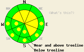
Near and above treeline, avalanche danger is MODERATE on NW-N-NE-E-SE aspects, 37 degrees and steeper. Below treeline, avalanche danger is LOW with pockets of MODERATE danger developing in open sun exposed areas on E-SE-S-SW-W aspects, 37 degrees and steeper in response to daytime warming. |
|
|
|
A weak weather system moved into the forecast area late yesterday afternoon. Air temperatures at the upper elevations dropped from well above to well below freezing between 3 pm and 5 pm. Overnight, new snow accumulations of 4 to 8 inches occurred above 7,000' along the Sierra Crest, with the greatest accumulations reported south of Hwy 50. New snow amounts decrease significantly further to the east. Remote sensors are reporting air temperatures in the upper teens and 20s this morning in most locations. Air temperatures are forecast to rise into the mid to upper 30s today. Ridgetop winds remain moderate in speed out of the southwest this morning. Winds are expected to shift to the west and remain moderate in speed during the day.
Yesterday, observations made on Mt. Judah (Donner Summit area) indicated that 2 to 4 inches of wet snow had formed at the surface at 8,200' on all but true north aspects at 3 pm. Below the wet surface snow, 1 to 2 inches of crust remained from the previous night's freeze, keeping the snow surface supportable. Wet surface snow amounts exceeded forecast expectations due to the limited cloud cover and later than forecast arrival of the weather system. Some very small skier triggered wet snow sluffs were noted in response to ski cuts on convex slope features 38 degrees and steeper. On north aspects, only the top 1 inch of the snowpack was melting at 8,200'. No evidence of wet snow instability was observed on north aspects.
Cooling air temperatures are expected to have created a good bond at the old/new snow interface as yesterday's wet surface snow refroze as new snow was deposited on top of it. Data from the snow study plot at Kirkwood Ski Area this morning indicates that the snowpack temperature at the old/new interface is just below freezing (-1 C). Avalanche activity that occurs today is expected to involve only the new snow from last night.
Avalanche concern #1 - Wind loading
Human triggered avalanches are possible today in steep wind loaded areas, mainly near and above treeline on NW-N-NE-E-SE aspects. Newly formed slabs in excess of 1 foot deep are expected to have formed overnight and will remain sensitive to human triggering today. In many areas along the Sierra Crest, sufficient new snow has fallen to create avalanches large enough to bury a person.
Avalanche concern #2 - Warming instability
As air temperatures warm above freezing, cloud cover breaks, and the high intensity April sun hits the snow surface, warming instability is expected to occur within the new snow in sun exposed areas. This will occur mainly on cross loaded or wind protected areas on E-SE-S-SW-W aspects at all elevations where new snow has accumulated. New snow may become very sensitive to human triggering in these areas with human triggered avalanches possible by this afternoon. Areas between 7,000' and 8,500' will be particularly suspect due to the combination of significant new snow accumulation and warming air temperatures.
Near and above treeline, avalanche danger is MODERATE on NW-N-NE-E-SE aspects, 37 degrees and steeper. Below treeline, avalanche danger is LOW with pockets of MODERATE danger developing in open sun exposed areas on E-SE-S-SW-W aspects, 37 degrees and steeper in response to daytime warming.
| 0600 temperature: | 20 deg. F. |
| Max. temperature in the last 24 hours: | 37 to 41 deg. F. |
| Average wind direction during the last 24 hours: | East shifting to southwest. |
| Average wind speed during the last 24 hours: | 38 mph |
| Maximum wind gust in the last 24 hours: | 59 mph |
| New snowfall in the last 24 hours: | 4 to 8 inches |
| Total snow depth: | 140 inches |
For 7000-8000 ft: |
|||
| Wednesday: | Wednesday Night: | Thursday: | |
| Weather: | Mostly cloudy skies with scattered snow showers. | Mostly cloudy skies with isolated snow showers. | Cloudy skies with scattered snow showers. |
| Temperatures: | 34 to 40 deg. F. | 18 to 25 deg. F. | 36 to 42 deg. F. |
| Wind direction: | W | SW | SW |
| Wind speed: | 10 to 15 mph with gusts to 30 mph. | 10 to 20 mph. | 10 to 15 mph with gusts up to 30 mph in the afternoon. |
| Expected snowfall: | Up to 1 in. | Trace in. | Up to 2 in. |
For 8000-9000 ft: |
|||
| Wednesday: | Wednesday Night: | Thursday: | |
| Weather: | Mostly cloudy skies with scattered snow showers. | Mostly cloudy skies with isolated snow showers. | Cloudy skies with scattered snow showers. |
| Temperatures: | 29 to 35 deg. F. | 15 to 22 deg. F. | 30 to 36 deg. F. |
| Wind direction: | W | W shifting to SW | SW |
| Wind speed: | 20 to 35 mph with gusts to 50 mph. | 20 to 30 mph with gusts to 60 mph. Decreasing to 15 to 20 mph with gusts to 30 mph after midnight. | 20 to 30 mph with gusts to 45 mph. |
| Expected snowfall: | Up to 1 in. | Trace in. | Up to 2 in. |


This website is owned and maintained by the non-profit arm of the Sierra Avalanche Center. Some of the content is updated by the USDA avalanche forecasters including the forecasts and some observational data. The USDA is not responsible for any advertising, fund-raising events/information, or sponsorship information, or other content not related to the forecasts and the data pertaining to the forecasts.

