In partnership with: 
|
April 13, 2009 at 7:00 am |
|
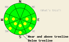
This morning the avalanche danger is LOW. Pockets of MODERATE avalanche danger should quickly develop due to daytime warming on E-SE-S-SW-W aspects 37 degrees and steeper at all elevations today. |
|
|
|
Today, the high-pressure ridge should bring one more sunny, warm day to the forecast area. A strong cold front approaching the forecast area should cause winds to start increasing this afternoon. As this front pushes the high-pressure ridge to the east, temperatures should drop overnight and stay much colder through Wednesday. This cold front does not have much moisture associated with it. The forecast area should only see a few inches of snow due to this system.
Yesterday, observations from the Mt. Judah area showed a few inches of heavy, unconsolidated snow still existed on the N-NE aspects above 7500'. A breakable, sun crust had formed on any sun-exposed areas on these aspects. A mix of large-grained, melt-freeze snow (corn) and heavy, wet unconsolidated snow comprised most snow surfaces on the easterly aspects. Almost all of the storm snow on the SE-S-SW-W aspects had experienced enough melting and refreezing to change into corn snow. Some small, skier-triggered sluffs occurred on N-NE-E aspects steeper than 37 degrees near 8000'. A few skier-triggered pinwheels also released on steep E-SE-S facing slopes between 7000' and 8200' after 12:30 pm. No other avalanche activity was reported.
Wet snow instabilities due to daytime warming will continue as the main avalanche concern today. The melting and refreezing that has occurred over the last few days should have allowed good drainage channels to form in the most recent snow. These drainage channels will help keep free water from saturating the upper snowpack and should make wet slab avalanches more difficult to trigger today. Overnight temperatures below freezing and mostly clear skies should have allowed a strong overnight refreeze. This strong refreeze should also help prevent wet snow instabilities from becoming large and widespread. However, more sun and warm temperatures will work to weaken the snow by melting bonds and creating free water in the snowpack today. Enough warming and melting could occur for human triggering of pinwheels and point-release avalanches to occur. Wet slab avalanches should be harder to trigger today; however, they are not impossible. The most likely places for any of these types of avalanche activity are steep, sun-exposed E-SE-S-SW-W aspects. Some pinwheels and roller balls could occur on lower-elevation, sun-exposed northerly slopes as well due to daytime warming. These should remain small and managable.
This morning the avalanche danger is LOW. Pockets of MODERATE avalanche danger should quickly develop due to daytime warming on E-SE-S-SW-W aspects 37 degrees and steeper at all elevations today.
| 0600 temperature: | 32 deg. F. |
| Max. temperature in the last 24 hours: | 44 deg. F. |
| Average wind direction during the last 24 hours: | West southwest |
| Average wind speed during the last 24 hours: | 14 mph |
| Maximum wind gust in the last 24 hours: | 39 mph |
| New snowfall in the last 24 hours: | O inches |
| Total snow depth: | 139 inches |
For 7000-8000 ft: |
|||
| Monday: | Monday Night: | Tuesday: | |
| Weather: | Partly cloudy | Partly cloudy with some isolated showers starting as rain this evening then changing to snow tonight. | Partly cloudy in the morning becoming mostly cloudy by the afternoon. Chance of snow showers. |
| Temperatures: | 49-55 deg. F. | 21-28 deg. F. | 27-33 deg. F. |
| Wind direction: | Southwest | Southwest | West |
| Wind speed: | 10 mph increasing to 15-25 mph with gusts to 40 mph | 15-25 mph with gusts to 40 mph | 15-25 mph with gusts to 35 mph increasing to 45 mph in the afternoon |
| Expected snowfall: | O in. | trace in. | up to 2 in. |
For 8000-9000 ft: |
|||
| Monday: | Monday Night: | Tuesday: | |
| Weather: | Partly cloudy | Partly cloudy with some isolated snow showers. | Partly cloudy in the morning becoming mostly cloudy by the afternoon. Chance of snow showers. |
| Temperatures: | 42-48 deg. F. | 20-26 deg. F. | 21-27 deg. F. |
| Wind direction: | Southwest | Southwest | West |
| Wind speed: | 10-15 mph with gusts to 35 mph increasing to 20-30 mph with gusts to 55 mph | 20-35 mph with gusts to 55 mph | 20-35 mph with gusts to 50 mph increasing to 65 mph in the afternoon |
| Expected snowfall: | O in. | trace in. | up to 2 in. |


This website is owned and maintained by the non-profit arm of the Sierra Avalanche Center. Some of the content is updated by the USDA avalanche forecasters including the forecasts and some observational data. The USDA is not responsible for any advertising, fund-raising events/information, or sponsorship information, or other content not related to the forecasts and the data pertaining to the forecasts.

