In partnership with: 
|
April 16, 2009 at 6:50 am |
|
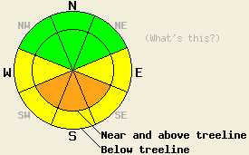
For the mountains directly south of Lake Tahoe, areas of CONSIDERABLE avalanche danger will develop near and above treeline on SE-S-SW aspects, 37 degrees and steeper in response to daytime warming. For all other locations, expect areas of MODERATE danger to develop at all elevations on E-SE-S-SW-W aspects, 37 degrees and steeper in response to daytime warming. |
|
|
|
The cold front that affected the forecast area yesterday has exited the region. Sunny skies and warming air temperatures are expected for today. New snow amounts of 1 to 6 inches exist across the forecast area. Air temperatures are in the teens and low 20s this morning. Ridgetop winds shifted to the west yesterday afternoon and back to the northeast overnight. Winds have remained moderate in speed.
Yesterday, north winds and lake effect snow produced increased snowfall accumulation in the mountains directly south of Lake Tahoe. Observations made on Waterhouse and Powerhouse Peaks (Luther Pass area) revealed 6 inches of new snow above 8,500'. Areas of wind loading up to 2 feet deep were observed near treeline at 9,300' on SE-S-SW aspects at the summit of each peak. Fair bonding of the new snow to the melt-freeze crust at the old/new snow interface was noted during stability tests. No other evidence of instability such as shooting cracks, collapsing, or whumpfing was observed.
Today, radiation from the strong mid April sun will create areas of instability within the new snow on southerly aspects as daytime warming occurs. Naturally occurring avalanches up to 2 feet deep are possible near and above treeline on steep SE-S-SW aspects in the mountains directly south of Lake Tahoe. Human triggered avalanches large enough to bury a person are probable in this area.
In other locations where significantly less new snow accumulated yesterday, small human triggered wet loose snow avalanches will be possible today as warming occurs and free water forms at the snow surface. Significant natural avalanche activity is unlikely in these areas. However, widespread roller ball activity is expected.
For the mountains directly south of Lake Tahoe, areas of CONSIDERABLE avalanche danger will develop near and above treeline on SE-S-SW aspects, 37 degrees and steeper in response to daytime warming. For all other locations, expect areas of MODERATE danger to develop at all elevations on E-SE-S-SW-W aspects, 37 degrees and steeper in response to daytime warming.
| 0600 temperature: | 17 deg. F. |
| Max. temperature in the last 24 hours: | 20 to 24 deg. F. |
| Average wind direction during the last 24 hours: | Northeast |
| Average wind speed during the last 24 hours: | 20 mph |
| Maximum wind gust in the last 24 hours: | 53 mph |
| New snowfall in the last 24 hours: | Trace to 2 inches |
| Total snow depth: | 136 inches |
For 7000-8000 ft: |
|||
| Thursday: | Thursday Night: | Friday: | |
| Weather: | Sunny skies. | Clear skies. | Sunny skies. |
| Temperatures: | 39 to 46 deg. F. | 21 to 29 deg. F. | 44 to 51 deg. F. |
| Wind direction: | NE | E | NE |
| Wind speed: | Up to 10 mph. | Up to 10 mph. | Up to 10 mph. |
| Expected snowfall: | O in. | O in. | O in. |
For 8000-9000 ft: |
|||
| Thursday: | Thursday Night: | Friday: | |
| Weather: | Sunny skies. | Clear skies. | Sunny skies. |
| Temperatures: | 38 to 44 deg. F. | 18 to 25 deg. F. | 43 to 49 deg. F. |
| Wind direction: | NE | NE | NE |
| Wind speed: | Around 10 mph with gusts to 25 mph. | Around 10 mph. | Around 10 mph with gusts to 25 mph. |
| Expected snowfall: | O in. | O in. | O in. |


This website is owned and maintained by the non-profit arm of the Sierra Avalanche Center. Some of the content is updated by the USDA avalanche forecasters including the forecasts and some observational data. The USDA is not responsible for any advertising, fund-raising events/information, or sponsorship information, or other content not related to the forecasts and the data pertaining to the forecasts.

