In partnership with: 
|
April 20, 2009 at 6:57 am |
|
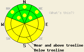
Early this morning, avalanche danger is LOW for all elevations and aspects. Avalanche danger will quickly rise to MODERATE on E-SE-S-SW-W aspects 37 degrees and steeper in response to daytime warming. Pockets of MODERATE danger will also form on NW-N-NE aspects, 37 degrees and steeper as warming occurs. |
|
|
|
High pressure continues to dominate the weather pattern. Another day of sunny skies and warm air temperatures are forecast for today. Maximum daytime air temperatures are expected to reach the upper 50s to upper 60s at all elevations. An air temperature inversion is in place this morning with air temperatures below 7,000' in the mid to upper 30s. Air temperatures above 7,000' are in the mid to upper 40s. Ridgetop winds shifted from west to north overnight and increased from light to moderate in speed. Winds are forecast to further shift to the northeast and east today and decrease to light in speed.
Yesterday, observations made on Incline Lake Peak (Mount Rose area) indicated that a decent refreeze had occurred overnight. Quality melt-freeze conditions with 1 to 3 inches of wet snow over a supportable crust existed at 9,600' on southerly aspects at 10:30 am. Below treeline at 9,200', areas of wet snow instability were noted on steep sun exposed NE aspects at 11:30 am. Small wet loose avalanches up to 4 inches deep and roller balls that entrained more snow occurred in response to ski cuts on slopes steeper than 40 degrees. Observation made on Castle Peak (Donner Summit area) on all aspects between 7,200' and 8,700' showed similar snow surface conditions to what was observed at higher elevations in the Mount Rose area. Additionally, some small skier triggered roller balls were observed to entrain wet surface snow in gullies on south aspects prior to 1 pm. Running melt water was heard underneath the snowpack and seen running over exposed rocks and dirt in a variety of locations. This signals that drainage within the snowpack is well established in this and other areas.
Only a weak snow surface refreeze is expected to have occurred overnight. Today, the combination of well above freezing air temperatures at the upper elevations this morning and rapid daytime warming will cause areas of instability to form quickly today. Most avalanche activity is expected to occur as human triggered wet loose snow avalanches on steep E-SE-S-SW-W aspects. Some smaller areas of wet surface snow instability are expected to form at all elevations on steep NW-N-NE aspects, especially in sun exposed areas. Natural avalanche activity is unlikely but not impossible today. Areas of cornice collapse could create larger wet loose snow avalanches. In areas where the snowpack sits on top of steep granite slabs, isolated wet slab avalanches are not impossible. At this time, wet slab avalanches remain unlikely on E-SE-S-SW-W aspects due to the already well established drainage of free water from the snowpack. With free water limited to the top 6 inches of the snowpack in most NW-N-NE aspect avalanche start zones, wet loose surface snow instability remains more likely than deeper wet slab instability at this time.
Early this morning, avalanche danger is LOW for all elevations and aspects. Avalanche danger will quickly rise to MODERATE on E-SE-S-SW-W aspects 37 degrees and steeper in response to daytime warming. Pockets of MODERATE danger will also form on NW-N-NE aspects, 37 degrees and steeper as warming occurs.
| 0600 temperature: | 47 deg. F. |
| Max. temperature in the last 24 hours: | 57 deg. F. |
| Average wind direction during the last 24 hours: | West shifting to north. |
| Average wind speed during the last 24 hours: | 12 mph |
| Maximum wind gust in the last 24 hours: | 36 mph |
| New snowfall in the last 24 hours: | O inches |
| Total snow depth: | 130 inches |
For 7000-8000 ft: |
|||
| Monday: | Monday Night: | Tuesday: | |
| Weather: | Sunny skies. | Clear skies. | Sunny skies in the morning, becoming partly cloudy with a slight chance of thunderstorms in the afternoon. |
| Temperatures: | 63 to 69 deg. F. | 35 to 43 deg. F. | 63 to 69 deg. F. |
| Wind direction: | E | SE | SE |
| Wind speed: | Up to 10 mph. | Up to 10 mph in the evening becoming light. | Up to 10 mph in the afternoon. |
| Expected snowfall: | O in. | O in. | O in. |
For 8000-9000 ft: |
|||
| Monday: | Monday Night: | Tuesday: | |
| Weather: | Sunny skies. | Clear skies. | Sunny skies in the morning, becoming partly cloudy with a slight chance of thunderstorms in the afternoon. |
| Temperatures: | 56 to 62 deg. F. | 38 to 44 deg. F. | 57 to 63 deg. F. |
| Wind direction: | E | SW | E |
| Wind speed: | Up to 10 mph with gusts to 25 mph. | Up to 10 mph in the evening, becoming light. | Up to 10 mph in the afternoon. |
| Expected snowfall: | O in. | O in. | O in. |


This website is owned and maintained by the non-profit arm of the Sierra Avalanche Center. Some of the content is updated by the USDA avalanche forecasters including the forecasts and some observational data. The USDA is not responsible for any advertising, fund-raising events/information, or sponsorship information, or other content not related to the forecasts and the data pertaining to the forecasts.

