In partnership with: 
|
November 30, 2009 at 7:26 am |
|
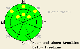
LOW avalanche danger exists across most of the forecast area. Pockets of MODERATE danger still remain on NW-N-NE aspects steeper than 32 degrees above 8700'. |
|
|
|
The winds have started to decrease and shift to the Southeast as a high-pressure ridge builds over the forecast area. This high-pressure ridge should also bring clear skies and warmer temperatures to the region today. The ridgetops and upper elevation locations have already started warming up, while an inversion keeps lower elevation and valley temperatures cool this morning. A small, low-pressure system passing north of the area tomorrow should bring light north and east winds back for Tuesday.
Observations from across the forecast area show a mix of wind scoured ice, some hard slabs, patches of unconsolidated new snow, rain crusts, and exposed rocks exist as the surface on most NW-N-NE-E aspects. Isolated human-triggered cracking and collapsing has occurred where small wind slabs formed on NW aspects above 8700' due to cross loading. The fragile combination of the Oct 19th facet layer on top of the early Oct. ice layer still exists in some areas above and below treeline on NW-N-NE aspects. On other aspects above 8700' and all aspects below 8700', thin, unconsolidated snow barely covers rocks, stumps, logs, dirt, and other toy-damaging, knee-breaking obstacles.
Today, those areas where the combination of the weak layer (the Oct. 19th facets) and a slippery bed surface (the early Oct. ice layer) still exists will remain the primary avalanche concern. On the NW-N-NE slopes where this combination remains, some human-triggerable avalanche activity is possible. Cross-loaded NW aspects above 8700' that have this layer combination will be the most suspect slopes. Probing with a ski pole and quick hand pits can indicate if the facet/ice layer combination exists under the surface.
Use extra cation in the backcountry today. A persistent weak layer with variable strength and distribution provides a complex avalanche hazard. Along with the avalanche hazard, the early season snowpack just barely covers the myriad of rocks, dirt, stumps, shrubbery, and other season-ending obstacles.
LOW avalanche danger exists across most of the forecast area. Pockets of MODERATE danger still remain on NW-N-NE aspects steeper than 32 degrees above 8700'.
| 0600 temperature: | 32 deg. F. |
| Max. temperature in the last 24 hours: | 32 deg. F. |
| Average wind direction during the last 24 hours: | Northeast shifting to the Southeast this morning |
| Average wind speed during the last 24 hours: | 35 mph |
| Maximum wind gust in the last 24 hours: | 78 mph |
| New snowfall in the last 24 hours: | O inches |
| Total snow depth: | 8-25 inches |
For 7000-8000 ft: |
|||
| Monday: | Monday Night: | Tuesday: | |
| Weather: | Sunny | Clear | Sunny |
| Temperatures: | 44-49 deg. F. | 28-34 deg. F. | 44-49 deg. F. |
| Wind direction: | Southeast | Variable | East |
| Wind speed: | 10 mph | 0-5 mph | 10 mph |
| Expected snowfall: | O in. | O in. | O in. |
For 8000-9000 ft: |
|||
| Monday: | Monday Night: | Tuesday: | |
| Weather: | Sunny | Clear | Sunny |
| Temperatures: | 38-46 deg. F. | 25-33 deg. F. | 38-46 deg. F. |
| Wind direction: | Southeast | Northeast | East |
| Wind speed: | 10-15 mph decreasing in the afternoon | up to 10 mph | 10 mph |
| Expected snowfall: | O in. | O in. | O in. |


This website is owned and maintained by the non-profit arm of the Sierra Avalanche Center. Some of the content is updated by the USDA avalanche forecasters including the forecasts and some observational data. The USDA is not responsible for any advertising, fund-raising events/information, or sponsorship information, or other content not related to the forecasts and the data pertaining to the forecasts.

