In partnership with: 
|
December 17, 2009 at 7:50 am |
|
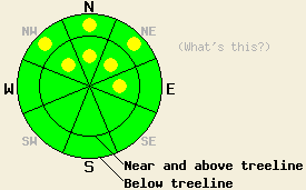
Near and above treeline, avalanche danger is LOW with isolated pockets of MODERATE danger on wind loaded NW-N-NE-E aspects, 35 degrees and steeper. Near treeline and below treeline, avalanche danger is LOW with pockets of MODERATE danger above 8,000' on NW-N-NE aspects, 35 degrees and steeper due to deep slab instability in some areas. Avalanches that occur below treeline may be large and destructive with severe consequences. |
|
|
|
High pressure is building over the forecast area with a mix of clouds and sun expected through the weekend. Air temperatures are forecast to rise into the mid 30s to low 40s at the upper elevations today. Ridgetop winds are expected to continue out of the southwest to west and decrease to light in speed.
Yesterday, observations made on Tamarack peak in the Mount Rose area continue to show evidence of persistent deep slab instability below treeline on NW-N-NE aspects above 8,000'. Fracture propagation tests were performed on the edge of a Dec 12 or Dec 13 natural avalanche on the N ridge of Hourglass Bowl (photos and pit profile) and on the far east ridge near the hwy summit (pit profile). Results showed that fracture propagation remains likely along the Oct 19 facet layer that is well developed near the base of the snowpack in both of these locations. On Incline Peak also in the Mount Rose area, observations made below treeline at 9,500' on a NE aspect revealed the absence of a faceted layer near the base of the snowpack and subsequently better snowpack stability (photos). Significant blowing snow was observed above treeline for the second day in a row, contributing to dense wind slab formation on NW-N-NE-E aspects.
Avalanche concern #1
Hard wind slabs exist above treeline on NW-N-NE-E aspects. These slabs will be difficult to trigger today, but isolated pockets of instability are expected to linger. Due to the nature of these hard slabs, snowpack failure may occur once an individual is well out onto the slab or after several individuals have traveled the slope.
Avalanche concern #2
Persistent deep slab instability remains below treeline on NE wind sheltered NW-N-NE aspects above 8,000'. Failure near the base of the snowpack on the Oct 19 facet layer is becoming increasingly difficult to trigger. However, once the snowpack fails large destructive avalanches with severe consequences are expected to occur as 2 to 4 feet of slab sit on top of this weak layer in most areas. Triggering of this deep instability is most likely to occur near exposed rocks, trees, or on the edges of the slab where a more shallow snowpack exists.
Near and above treeline, avalanche danger is LOW with isolated pockets of MODERATE danger on wind loaded NW-N-NE-E aspects, 35 degrees and steeper. Near treeline and below treeline, avalanche danger is LOW with pockets of MODERATE danger above 8,000' on NW-N-NE aspects, 35 degrees and steeper due to deep slab instability in some areas. Avalanches that occur below treeline may be large and destructive with severe consequences.
| 0600 temperature: | 25 to 30 deg. F. |
| Max. temperature in the last 24 hours: | 32 to 38 deg. F. |
| Average wind direction during the last 24 hours: | west southwest |
| Average wind speed during the last 24 hours: | (sensor error, only past 12 hours available) 22 mph |
| Maximum wind gust in the last 24 hours: | (sensor error, only past 12 hours available) 32 mph |
| New snowfall in the last 24 hours: | O inches |
| Total snow depth: | 38 to 55 inches |
For 7000-8000 ft: |
|||
| Thursday: | Thursday Night: | Friday: | |
| Weather: | Partly to mostly cloudy skies. | Mostly cloudy skies. | Mostly cloudy skies in the morning, becoming partly cloudy. |
| Temperatures: | 35 to 42 deg. F. | 25 to 31 deg. F. | 36 to 43 deg. F. |
| Wind direction: | W | W | NW shifting to N in the afternoon. |
| Wind speed: | Light winds around 10 mph in the afternoon. | Light winds up to 10 mph after midnight. | Around 10 mph. |
| Expected snowfall: | O in. | O in. | O in. |
For 8000-9000 ft: |
|||
| Thursday: | Thursday Night: | Friday: | |
| Weather: | Partly to mostly cloudy skies. | Mostly cloudy skies. | Mostly cloudy skies in the morning, becoming partly cloudy. |
| Temperatures: | 34 to 41 deg. F. | 22 to 29 deg. F. | 36 to 43 deg. F. |
| Wind direction: | W | W | NW |
| Wind speed: | Around 10 mph. | 10 to 15 mph with gusts to 25 mph after midnight. | 10 to 15 mph. |
| Expected snowfall: | O in. | O in. | O in. |


This website is owned and maintained by the non-profit arm of the Sierra Avalanche Center. Some of the content is updated by the USDA avalanche forecasters including the forecasts and some observational data. The USDA is not responsible for any advertising, fund-raising events/information, or sponsorship information, or other content not related to the forecasts and the data pertaining to the forecasts.

